
27.1
PDI
14.3 mi
DISTANCE
4,630 ft
GAINED
6.1 %
AVG. GRADE
FULL CLIMB STATS
INTRO
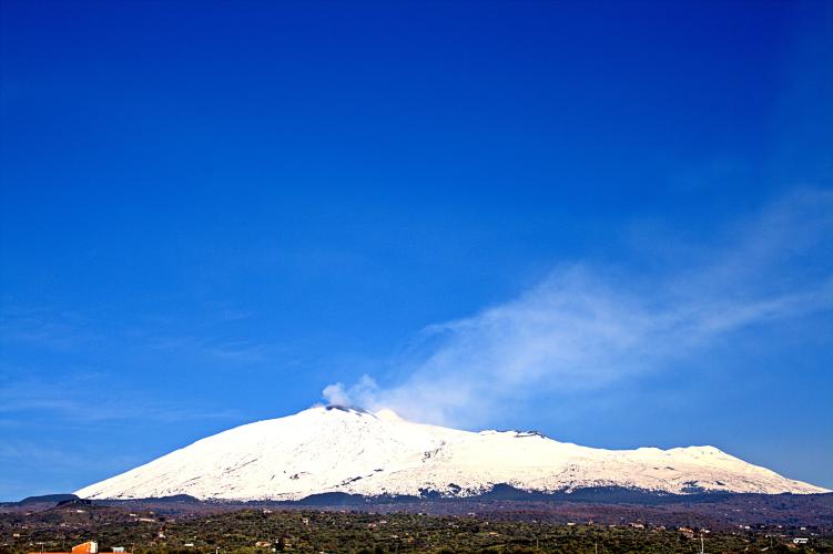
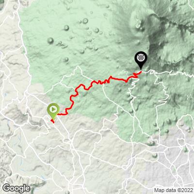
Mt. Etna (Biancavilla) climbs 23.0 km (14.3 mi) up the southwestern flank of Europe's largest active volcano, gaining 1,411 m (4,630 ft) at a 6.1% average grade and finishing around 1,915 m (6,280 ft) near Rifugio Sapienza. It's one of several paved roads that reach the same high mountain refuge from towns around Etna's base, this one climbing out of Biancavilla rather than Belpasso, Nicolosi, or Zafferana Etnea. The road climbs through Biancavilla's citrus and vineyard terraces before working up through pine forest into the bare volcanic terrain near the road's end, the trailhead for Rifugio Sapienza's cable car and Etna Sud hiking network.
This exact route, crossing the Strada Milia partway up, was the official categorized climb in Stage 4 of the 2022 Giro d'Italia, a 172 km stage from Avola won by Lennard Kämna, with Juan Pedro López taking the race lead - the same junction had also featured in the 2018 Giro.
Etna has been in a continuous eruptive phase since December 2025, with activity concentrated at the summit craters well above this route's finish. Rifugio Sapienza and the road have generally stayed open through it, but access can be restricted on short notice on INGV Osservatorio Etneo guidance - check current status before you go.
Biancavilla has a distinctive origin story among Etna's base towns: it was founded in 1488 by Albanian (Arbëreshë) refugees who fled Ottoman advances after the death of the resistance leader Skanderbeg.
PLAN YOUR ROUTE
 We've partnered with Sherpa-Map.com to bring you the best route planning tool. With a PRO Membership you can use this climb as a reference when creating your route.
 Mt. Etna (Biancavilla) climbs 23.0 km (14.3 mi) and gains 1,411 m (4,630 ft), averaging 6.1% from Biancavilla at about 526 m (1,726 ft) up to roughly 1,913-1,917 m (6,275-6,289 ft) near Rifugio Sapienza.
Like most routes up Etna, the grade is inconsistent rather than a steady grind - long, moderate stretches through the forested mid-mountain alternate with steeper pitches as the road switchbacks higher. The steepest kilometer averages 10.1%, and the steepest mile 8.3%. The 2022 Giro d'Italia's categorized climb on this same road, measured over its final 23.1 km, averaged 5.9% with a maximum pitch of 12.5% - both consistent with the pattern here.
Roadway: Paved the entire way from Biancavilla to Rifugio Sapienza, and well-maintained enough to have hosted a Giro d'Italia mountain finish in 2022. Etna remains an active volcano with a continuous eruptive phase ongoing since December 2025 - activity has stayed concentrated at the summit craters, well above this route, and Rifugio Sapienza and the road up have generally stayed open through it, but the Città Metropolitana di Catania can restrict access on short notice based on INGV Osservatorio Etneo guidance. Check current status before you go.
Traffic: Light to moderate through Biancavilla's outskirts and the lower citrus and vineyard terraces, easing further as the road climbs into forest. Expect more company - hikers, jeep tours, and the occasional tour bus - near the top, since Rifugio Sapienza is Etna's main southern-approach hub.
Parking: Biancavilla has ordinary on-street parking in town near the start. At the finish, Rifugio Sapienza has a large public parking area serving the cable car station and hiking trailheads.
Biancavilla has grocery stores, bakeries, and cafes for a final stop before heading up - it's a full working town, not a tourist outpost. Services thin out quickly once you leave town; there's little reliable food or water directly on the climb until Rifugio Sapienza at the top, which has restaurants, a bar, and a shop serving the cable car and hiking crowds. Carry enough water and food for the full 23 km, especially in summer heat on the lower slopes.
Before heading out on any cycling adventure check out our Things to Bring on a Cycling Trip and use our interactive check list to ensure you don't forget anything.
Biancavilla has a different origin story than most of Etna's base towns: it was founded in 1488 by Albanian (Arbëreshë) refugees who fled after the death of the resistance leader Skanderbeg and the Ottoman advance into Albania. That heritage is still visible in the town's name for its patron saint, Maria Santissima dell'Elemosina, and in local surnames and traditions with Albanian roots - worth a stop in the historic center before or after the ride.
This is also the exact road the Giro d'Italia climbed in 2022, when Stage 4 finished at Rifugio Sapienza and Lennard Kämna took the stage win as Juan Pedro López pulled on the race leader's jersey - a point of local pride worth knowing before you ride the same switchbacks. Biancavilla sits about 30 km from Catania, a practical base with an international airport if you're combining this with Etna's other paved approaches from Belpasso, Zafferana Etnea, or the steeper eastern side through San Giovanni Montebello.
ROUTE MAP
MEMBER RATING
CURRENT WEATHER
PJAMM TRIPS ADVENTURE STARTER BUNDLES
Check out PJAMM Adventure's prepackaged (self-guided) cycling trips. They will help you plan, document and conquer your next adventure.
NEARBY CLIMBS (0) RADIAL PROXIMITY
FROM No Climbs Found
MEMBER REVIEWS & COMMENTS
Let us know what you thought of this climb. Signup for our FREE membership to write a review or post a comment.
Already have an account?
LOG IN HERE
