
20.1
PDI
18.9 mi
DISTANCE
4,461 ft
GAINED
4 %
AVG. GRADE
FULL CLIMB STATS
INTRO
Monte Sirino is a long southern Apennine ride: 30.4 km (18.9 mi) from the Noce valley near Trecchina to the upper slopes of the Sirino massif, gaining 1,360 m (4,461 ft) at a 4.0% average from 207 m (679 ft) to 1,413 m (4,637 ft). It is a patient climb: the first 10 km (6.2 mi) mostly run at 4-6%, and the steepest stretches don't arrive until km 18-19 and km 27-28, where the road reaches 7-10%.
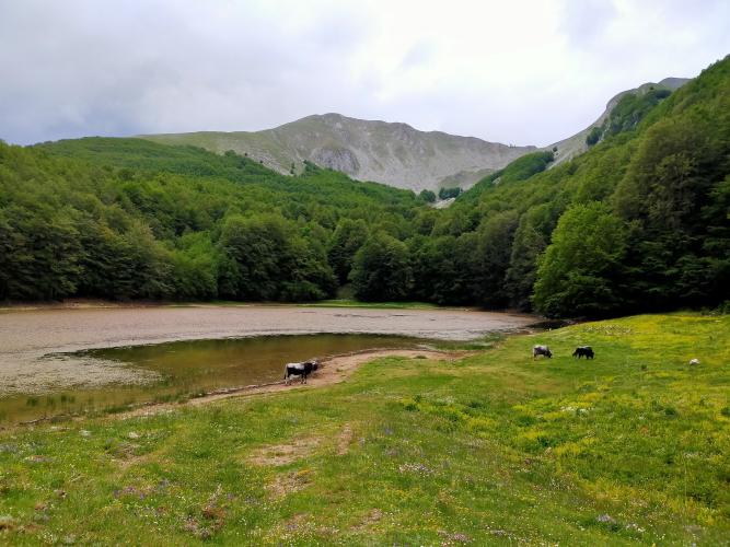
The route follows the old SS585 and the SP3 through Lauria, passes the hamlet of Pecorone on the former SS19, and then climbs the hills above town toward the massif. The finish, at 1,413 m (4,637 ft), is about 1 km (0.6 mi) northeast of Lago Laudemio, a small glacial lake at about 1,525 m (5,003 ft) that is the southernmost glacial lake in Italy; above it rise Monte Sirino (1,907 m / 6,257 ft) and Monte Papa (2,005 m / 6,578 ft).
Sirino is also the area's winter playground: the ski area has a chairlift and five ski lifts, and its slopes often stay open into late spring. A shorter approach starts in Lagonegro and covers about 17.9 km (11.1 mi) at 5.6% to roughly 1,525 m.
PLAN YOUR ROUTE
 We've partnered with Sherpa-Map.com to bring you the best route planning tool. With a PRO Membership you can use this climb as a reference when creating your route.
Monte Sirino climbs 1,360 m (4,461 ft) over 30.4 km (18.9 mi) for a 4.0% average, from 207 m (679 ft) to 1,413 m (4,637 ft), with 154 m (504 ft) of descent along the way. It is a long, uneven climb: about 4-6% for the first 10 km (6.2 mi), a rolling middle section with short descents or flats around km 15-16, km 21 and km 26, and two harder pushes late on.
The steepest 0.5 km (0.3 mi) averages 10.5%, the steepest kilometer (0.6 mi) 9.6%, and the steepest 2 km (1.2 mi) 8.9%. The steepest 5 km (3.1 mi) average 6.4% and the steepest 10 km (6.2 mi) 5.1%, and the steepest 91 m (100 yd) reaches 11.8%.
The first push comes at km 18-19 (7-9%), and the second, harder one at km 27-28 (8-10%). Save something for them, because they arrive after the long middle section; the final 2 km (1.2 mi) settle back to about 5%.
Roadway: The route is on paved public roads: the former SS585 near Trecchina, the SP3 Tirrena and the former SS19 through the Lauria area, and then local roads up toward Lago Laudemio. The massif is a ski area, so snow can linger into late spring; plan on late spring through autumn.
Traffic: Traffic is heaviest on the lower half, where the route follows the old state roads through and around Lauria, the area's largest town. Higher up, the road mainly serves the massif's lake and ski area.
Parking: Our start is on the former SS585 near Trecchina, with no dedicated lot. Park in Trecchina or Lauria and ride to the start, or begin in Lauria to shorten the ride.
Carry plenty of water and food: at 30.4 km (18.9 mi) this is a long ride, so fill your bottles in Lauria before the road climbs toward the lake.
With 8-10% pitches late in the ride, a compact crankset with a 30-34 tooth cassette is the sensible choice. Weather on the massif can differ from the valley, so bring a rain jacket and a warm layer; the finish area sits at roughly 1,400 m (4,593 ft) and the lake at about 1,525 m (5,003 ft).
Before heading out on any cycling adventure check out our Things to Bring on a Cycling Trip and use our interactive check list to ensure you don't forget anything.
Lauria is the practical base for this climb: it is the area's largest town (about 11,700 residents), with a ruined castle linked to Ruggiero di Lauria, the Armo sanctuary and a history marked by the 1806 massacre by Napoleonic troops. Local food includes lagane e ceci, raschatielli gnocchi, lamb and goat dishes, cured meats and ricotta, and the local soft drink is often mixed with red wine.
Trecchina, near the start, has the 1857 church of San Michele Arcangelo and the Grotta Sant'Angelo cave, and is known for its pane di Trecchina, nut pastries and chestnut ice cream. The coast at Maratea is close - the coastal Cristo di Maratea climb starts about 10 km (6 mi) away as the crow flies - and the SS585 connects to the motorway at Lagonegro Nord.
On foot, Lago Laudemio has been a regional reserve since 1985, and trails from Lago Sirino climb to the Madonna del Sirino sanctuary near the summit at about 1,900 m (6,234 ft) and on to Monte Papa. To see other climbs nearby, or to build a custom route from here, use our Routes in the Area tool.
ROUTE MAP

MEMBER RATING
CURRENT WEATHER
PJAMM TRIPS ADVENTURE STARTER BUNDLES
Check out PJAMM Adventure's prepackaged (self-guided) cycling trips. They will help you plan, document and conquer your next adventure.
NEARBY CLIMBS (0) RADIAL PROXIMITY
FROM No Climbs Found
MEMBER REVIEWS & COMMENTS
Let us know what you thought of this climb. Signup for our FREE membership to write a review or post a comment.
Already have an account?
LOG IN HERE
