
17
PDI
7.6 mi
DISTANCE
2,738 ft
GAINED
6.9 %
AVG. GRADE
FULL CLIMB STATS
INTRO
PLAN YOUR ROUTE
 We've partnered with Sherpa-Map.com to bring you the best route planning tool. With a PRO Membership you can use this climb as a reference when creating your route.
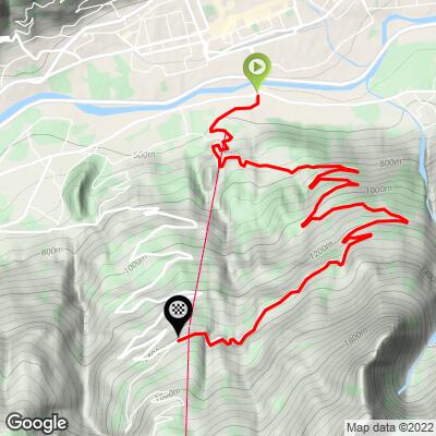
From 569 m (1867 ft) at Pont Suaz to 1404 m (4605 ft) at the Les Fleurs junction is 12.2 km (7.6 mi), with 835 m (2738 ft) of gain at 6.9% on average.
The climb is front-loaded. From the start to about 9.5 km (5.9 mi) it averages 7.6%, and the 4.5-8.5 km stretch above Charvensod holds 8-10% almost without a break. The steepest kilometer averages 9.7% and the hardest 5 km (3.1 mi) 8.5%. The one real breather comes between 3.5 and 4.5 km (2.2-2.8 mi), where the grade drops to about 5%.
Over the final 2.6 km (1.6 mi) the road eases to about 4% on average, with a near-flat section around 10.5 km (6.5 mi), before a last gentle rise to the junction.
Roadway: Asphalt the whole way, on the road signed for Pila through Charvensod. The first couple of kilometers are village streets with junctions and driveways; above Charvensod it becomes a proper mountain road with a long series of hairpins.
Traffic: Local traffic through Charvensod, and resort traffic heading for Pila higher up - busiest on ski-season and summer weekends, much quieter midweek.
Parking: The obvious place is the car park at the Pila gondola's valley station in Pont Suaz, right at the start (Street View). From central Aosta it's a short ride across the Dora Baltea.
Gear: Nothing here is brutal - no full kilometer reaches 10% - but the long middle section at 8-10% wants a gear you can keep turning for the best part of an hour. If you're going on to Pila, bring a layer: the resort is 400 m higher than the finish and the descent is long.
Provisions: Stock up in Aosta or at Pont Suaz. Once you're above Charvensod there's little until the resort itself, where the bars and restaurants of Pila are 4.8 km past the finish.
Before heading out on any cycling adventure check out our Things to Bring on a Cycling Trip and use our interactive check list to ensure you don't forget anything.
Aosta makes the easiest base: the old Roman town of Augusta Praetoria still has its Arch of Augustus and the Porta Praetoria gate in the center, plenty of hotels and restaurants, and trains down the valley toward Turin. Pont Suaz is only a couple of kilometers from the center.
The natural extension is to keep climbing from Les Fleurs to Pila - our Pila page covers the Gressan road the Giro used in 2026, and descending that way makes a good loop back to Aosta. If you'd rather not ride down at all, the gondola links the resort with Pont Suaz.
Across the valley there's a lot more within reach - the Colle del Gran San Bernardo, Verrogne and Saint-Pierre-Vetan all start a short ride from Aosta, and Routes in the Area, on this page, shows how they fit together.
ROUTE MAP
MEMBER RATING
CURRENT WEATHER
PJAMM TRIPS ADVENTURE STARTER BUNDLES
Check out PJAMM Adventure's prepackaged (self-guided) cycling trips. They will help you plan, document and conquer your next adventure.
NEARBY CLIMBS (0) RADIAL PROXIMITY
FROM No Climbs Found
MEMBER REVIEWS & COMMENTS
Let us know what you thought of this climb. Signup for our FREE membership to write a review or post a comment.
Already have an account?
LOG IN HERE
