
21.6
PDI
8 mi
DISTANCE
3,205 ft
GAINED
7.6 %
AVG. GRADE
FULL CLIMB STATS
INTRO
PLAN YOUR ROUTE
 We've partnered with Sherpa-Map.com to bring you the best route planning tool. With a PRO Membership you can use this climb as a reference when creating your route.
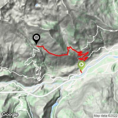
 Verrogne averages 7.6% over 12.9 km (8.0 mi), climbing 977 m (3,205 ft) from 619 m (2,030 ft) in Sarre to 1,595 m (5,234 ft). It is a consistently hard grade rather than one big wall: the steepest 10 km (6.2 mi) average 8.0%, the steepest 5 km (3.1 mi) 8.8%, the steepest 2 km (1.2 mi) 8.9% and the steepest kilometre 11.0%, with the steepest half kilometre (0.3 mi) at 13.4%.
Because the grade rarely drops below 7%, there are almost no flat sections to recover on, and the hairpins keep the effort steady rather than punchy. A compact chainset with a wide-range cassette makes it far more comfortable.
Roadway: The road is paved the whole way. It follows the Strada Verrogne Bellun, a narrow regional road, and riders report fresh tarmac laid ahead of the Giro's 2019 visit. Most of the climb is in full sun, and there is little shade to break up a hot day.
Traffic: Very light. The road serves the hamlets on the mountainside rather than a through route, and riders consistently describe it as quiet - the busier roads are down on the valley floor around Aosta and Sarre.
Parking: Sarre is a town of about 4,800 people a few kilometres west of Aosta, so if you are staying in Aosta the easiest option is to ride out to the start rather than drive. If you do drive, park in town in Sarre rather than on the narrow mountain lanes.
Gear: The road is paved and steady at 7-8%, so a compact chainset with a wide-range cassette is the sensible setup; a standard road bike is all you need.
Provisions: Start with two full bottles in summer, as the climb is exposed to the sun and can be very hot. Riders report a mountain water tap near the top with cold water, and bring a light layer for the descent.
Before heading out on any cycling adventure check out our Things to Bring on a Cycling Trip and use our interactive check list to ensure you don't forget anything.
Aosta is the natural base, with the widest choice of hotels and restaurants in the valley. In Sarre itself, Sarre Castle is the town's main landmark and worth a look before you start.
Verrogne is a piece of Giro d'Italia history from two different editions, and the Giro d'Italia's own 'Mine Valley 2' cycle route loops Cogne - Verrogne - Cogne for about 78 km (48.5 mi) with 2200 m (7,218 ft) of climbing, which makes a big day out. Our Pila and Saint Pierre-Vetan pages cover the neighbouring climbs on the Aosta side of the valley.
With a finish at nearly 1,600 m, check current conditions at the top before you go with our Weather tool.
ROUTE MAP
MEMBER RATING
CURRENT WEATHER
PJAMM TRIPS ADVENTURE STARTER BUNDLES
Check out PJAMM Adventure's prepackaged (self-guided) cycling trips. They will help you plan, document and conquer your next adventure.
NEARBY CLIMBS (0) RADIAL PROXIMITY
FROM No Climbs Found
MEMBER REVIEWS & COMMENTS
Let us know what you thought of this climb. Signup for our FREE membership to write a review or post a comment.
Already have an account?
LOG IN HERE
