
24.5
PDI
7.8 mi
DISTANCE
3,418 ft
GAINED
8.3 %
AVG. GRADE
FULL CLIMB STATS
INTRO
PLAN YOUR ROUTE
 We've partnered with Sherpa-Map.com to bring you the best route planning tool. With a PRO Membership you can use this climb as a reference when creating your route.
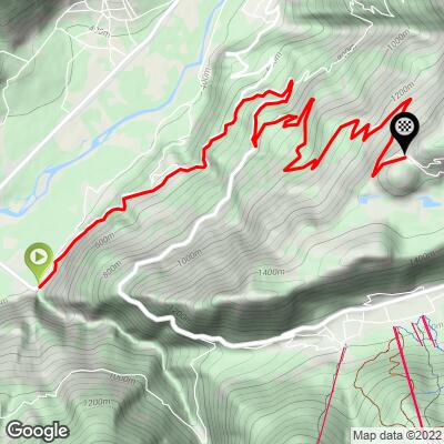
 Valico di Santa Cristina averages 8.3% over 12.6 km (7.8 mi) from Stazzona, gaining 1,042 m (3,418 ft) from 431 m (1,413 ft) up to the pass at 1,473 m (4,831 ft).
The first kilometers out of Stazzona are the mildest of the climb, running alongside the road toward Aprica before the real gradient begins at the turnoff onto Via Maranta.
From there the pitch rarely lets up: the steepest 100 meters average 12.3%, the steepest quarter-mile averages 12.1%, and the steepest half-mile still averages 11.7%. Even the steepest 5 km stretch of the route holds at 10.0%, which gives a sense of how sustained the effort is once the road tips upward in earnest.
The final kilometers near Mezzamonte and on to the pass are where most riders feel the climb the most, with several hairpins pitching into the mid-teens.
Roadway: Via Maranta is fully paved and has been kept in good condition, with the roughest patches resurfaced in recent years as the surrounding Valtellina roads have hosted the Giro d'Italia. It's a narrow, two-lane mountain road for virtually its entire length above the Stazzona turnoff.
Traffic: Traffic is heavier for the first kilometers out of Stazzona, where the route shares the road with cars headed toward Aprica on the SS38. Once you turn off onto Via Maranta the traffic drops off sharply, and the rest of the climb is quiet, local-only riding.
Parking: Stazzona is a small hamlet with limited formal parking, so most riders leave their car along the roadside near the village center or at the junction where Via Maranta begins to climb. Riders based in nearby Tirano or Aprica can also start from those towns and treat the approach to Stazzona as a rolling warm-up before the real climbing begins.
This is a demanding HC ascent with sustained pitches averaging into the low teens, so a compact crankset (34/50) paired with a wide-range cassette (32-34t low gear) is strongly recommended, especially for the steeper final kilometers near Mezzamonte.
There are no shops or fountains along the climb itself, so fill bottles and carry food before leaving Stazzona - the village itself has no services, so stock up in Tirano or Aprica beforehand. A lightweight rain jacket is worth carrying even on clear days, since Alpine weather over the Valtellina can turn quickly at altitude.
Before heading out on any cycling adventure check out our Things to Bring on a Cycling Trip and use our interactive check list to ensure you don't forget anything.
The Valtellina is well known beyond cycling for its wine, and the town of Teglio near the top of this climb is considered the birthplace of pizzoccheri, the valley's signature buckwheat pasta - a fitting post-ride meal after Santa Cristina's steep final kilometers.
Riders staying in the area often combine Santa Cristina with the nearby Passo di Mortirolo (Mazzo di Valtellina side), home to the Pantani memorial at hairpin 11, or with Passo di Gavia further up the valley - both are within easy reach for a multi-day Valtellina cycling trip.
The climb is best ridden from late spring through early fall; check regional road-condition alerts for the SS38 corridor before winter and early-spring trips, since the higher stretches of the surrounding valley can hold snow into April.
ROUTE MAP
MEMBER RATING
CURRENT WEATHER
PJAMM TRIPS ADVENTURE STARTER BUNDLES
Check out PJAMM Adventure's prepackaged (self-guided) cycling trips. They will help you plan, document and conquer your next adventure.
NEARBY CLIMBS (0) RADIAL PROXIMITY
FROM No Climbs Found
MEMBER REVIEWS & COMMENTS
Let us know what you thought of this climb. Signup for our FREE membership to write a review or post a comment.
Already have an account?
LOG IN HERE
