32
PDI
20 mi
DISTANCE
4,976 ft
GAINED
4.7 %
AVG. GRADE
FULL CLIMB STATS
INTRO
PLAN YOUR ROUTE
This climb averages 0%. The steepest quarter mile of this climb is 0%. NaN miles of the climb is at or above 10% grade. The gradient on this climb is broken down as follows:
See more details and tools regarding this climb's grade via our interactive Profile Tool.
See more details and tools regarding this climb's grade via our interactive Profile Tool.
Information Not Available
If you have any information regarding this climb, we'd like to hear from you. Click the CONTRIBUTE button to share your thoughts with us.
Information Not Available
If you have any information regarding this climb, we'd like to hear from you. Click the CONTRIBUTE button to share your thoughts with us.
Before heading out on any cycling adventure check out our Things to Bring on a Cycling Trip and use our interactive check list to ensure you don't forget anything.
Information Not Available
If you have any information regarding this climb, we'd like to hear from you. Click the CONTRIBUTE button to share your thoughts with us.
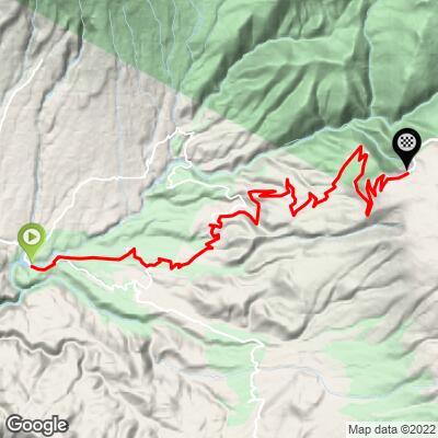
ROUTE MAP
MEMBER RATING
CURRENT WEATHER
PJAMM TRIPS ADVENTURE STARTER BUNDLES
Check out PJAMM Adventure's prepackaged (self-guided) cycling trips. They will help you plan, document and conquer your next adventure.
NEARBY CLIMBS (0) RADIAL PROXIMITY
FROM No Climbs Found
MEMBER REVIEWS & COMMENTS
Let us know what you thought of this climb. Signup for our FREE membership to write a review or post a comment.
Already have an account?
LOG IN HERE
ayale


I started in Arequipa which added quite a bit of climbing and some thrilling city riding but the listed starting point would be fantastic for a climb without any descent. The gravel starts after Chiguata and it is chunky with some washboard and occasional sand. I was on a gravel bike with 35mm lightly treaded tires and I wouldn't want anything less. As far as I can tell, all of the locals use mountain bikes for these roads.
I know the scenery is incredible up there and most people see vicuñas but unfortunately it was very foggy once I got to about 13,000 feet. It was also cold at the top of course...about 45F on the day I was up there.
There are some tiendas for resupply in Chiguata which is a very charming little town. If you are going to go through the tunnel at the top, you should have a headlight because it's not lit and it's just long enough to get very dark in there. There is some traffic so use caution on the bends.
Strava: https://www.strava.com/activities/10470598887