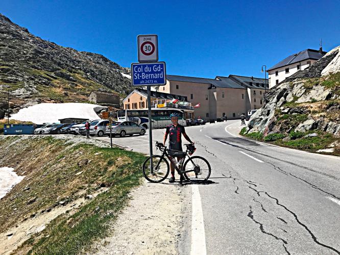
Colle del Gran San Bernardo Bike Climb - PJAMM Cycling

10.2
FIETS
21.4 mi
DISTANCE
5,720 ft
GAINED
5.1 %
AVG. GRADE

FULL CLIMB STATS

Page Contributor(s): Ard Oostra, Montreux, Switzerland

INTRO

This 21.4 mile bike climb is located in Valle d'Aosta, Italy. The average gradient is 5.1% and there is a total elevation gain of 5,720 ft, finishing at 7,675 ft.

Use the profile tool, route map, and weather forecast to conquer this cycling climb.

See more details and tools regarding this climb's grade via our interactive Profile Tool.
Information Not Available

If you have any information regarding this climb, we'd like to hear from you. Click the CONTRIBUTE button to share your thoughts with us.

Information Not Available

If you have any information regarding this climb, we'd like to hear from you. Click the CONTRIBUTE button to share your thoughts with us.

Before heading out on any cycling adventure check out our Things to Bring on a Cycling Trip and use our interactive check list to ensure you don't forget anything.
Information Not Available

If you have any information regarding this climb, we'd like to hear from you. Click the CONTRIBUTE button to share your thoughts with us.

ROUTE MAP

MEMBER RATING

Not Yet Rated
-
Road
-
Traffic
-
Scenery

CURRENT WEATHER

PJAMM TRIPS ADVENTURE STARTER BUNDLES

Check out PJAMM Adventure's prepackaged (self-guided) cycling trips. They will help you plan, document and conquer your next adventure.
ALL TRIPS
Browse all of our prepackaged trips and find your next adventure!

NEARBY CLIMBS (0) RADIAL PROXIMITY

FROM
No Climbs Found

MEMBER REVIEWS & COMMENTS

Let us know what you thought of this climb. Signup for our FREE membership to write a review or post a comment.
Already have an account?
ROUTE MAP
PROFILE TOOL
Route Data
S.G. (%)
hide
Segment Data
hide

Climb Profile Not Found
CLIMB SUMMARY

Cycling Colle del Gran San Bernardo (Italian side)

Ride 34 kilometers gaining 1,745 meters at 5.1% average grade.

“[Great St. Bernard Pass] is the third highest road pass in Switzerland. It connects Martigny in the canton of Valais in Switzerland with Aosta in the region Aosta Valley in Italy. It is the lowest pass lying on the ridge between the two highest mountains of the Alps, Mont Blanc and Monte Rosa. The pass itself is located in Switzerland in the canton of Valais, very close to Italy.”  Wikipedia - Great St Bernard Pass

This is a historical pass that dates back to well Before Common Era.  According to Wikipedia, the pass first appears in history in 390 BC when Celtic tribes of the Boii and Lingones used it to invade Italy.  Famous generals of note have used the pass for military purposes - one going north and the other south:

1.        First came Julius Caesar (or actually his top commander, Servius Galba) in 57 BC.  Galba having failed to seize the pass.  Augustus later succeeded in securing the pass for Rome and a road soon thereafter built under the direction of Roman Emperor Claudius.

2.        Next up - Napolleon from the north. In May, 1800, Napoleon Bonaparte sent 40,000 men over the pass to attack an Austrian army that had laid siege to French-occupied Genoa.  See, Wikipedia - Great St Bernard Pass

So to has the French Grand Tour passed over Colle del Gran San Bernardo 5 times in the past. Great St Bernard Pass 

It appears the pass name derives from the hospice for travellers constructed there in 1049 by, you guessed it Saint Bernard of Menthon.  So to does the name for the great snow rescue dog derive! Wikipedia - Great St Bernard Hospice

Top - May, 2021

Thank you Ard!!

Access to full Climb Summary requires a PJAMM Cycling PRO Membership!

It takes less than a minute to sign up & with your PRO membership you can:
  • Rate climbs, post comments and share your experiences on any of our climb pages
  • Create bucket lists of climbs & mark the dates you complete them
  • Weather data for all climbs - Start & Finish
  • Upload photos to your member page to customize your PJAMM Cycling experience
  • Utilize all of our interactive tools - Profile & Routes in Area
  • Download climb route .gpx files
LEARN MORE
SIGN UP

Already have an account? LOG IN HERE