
22
PDI
17 mi
DISTANCE
4,459 ft
GAINED
4.7 %
AVG. GRADE
FULL CLIMB STATS
INTRO
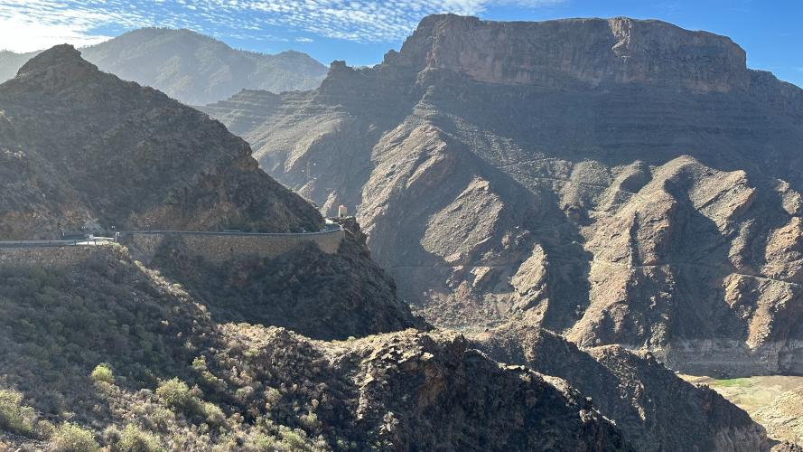
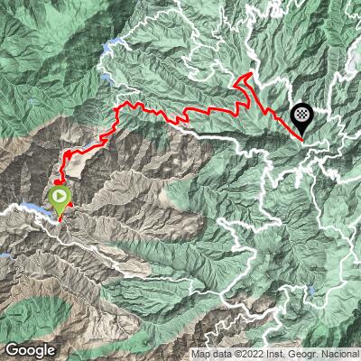
Just past the Valley of the Tears is another incredible climb, and nearly as difficult if you start at the coast. From the Presa del Parralillo, where the GC-606 peels off toward El Carrizal, this route stays on the GC-210 and heads north instead: 27.4 km (17 mi) with 1359 m (4,459 ft) of climbing, from 357m (1,171 ft) at the reservoir to 1635 m (5,364 ft) on the crest of the island near Cruz de Tejeda.
The front end is the hard part. The first 8 km (5.0 mi) average 7.5%, switchbacking up out of the barranco past the Mirador del Molino - a restored stone windmill on a viewpoint looking straight down onto the Parralillo dam and across the Caldera de Tejeda to Roque Bentayga and Roque Nublo. The road then eases past the Acusa hamlets below the Mesa de Acusa, a flat-topped mesa riddled with cave dwellings and ancient granaries, before climbing on to Artenara, Gran Canaria's highest village, at about 1240 m (4,068 ft).
From Artenara the GC-21 and GC-150 wind east through pine forest along the island's high spine, passing close to the Pinos de Gáldar, to finish at the Degollada de las Palomas viewpoint. Artenara lies within the Risco Caído and Sacred Mountains of Gran Canaria cultural landscape, a UNESCO World Heritage Site since 2019, and on a quiet day it feels as remote as any road on the island.
PLAN YOUR ROUTE
 We've partnered with Sherpa-Map.com to bring you the best route planning tool. With a PRO Membership you can use this climb as a reference when creating your route.
 This climb covers 27.4 km (17.0 mi) and gains 1,359 m (4,459 ft) at a 4.7% average grade, with only 81 m (266 ft) of descending along the way - but the difficulty is heavily front-loaded.
The first 8 km (5.0 mi) from the Presa del Parralillo climb 600 m (1,969 ft) at about 7.5%. After a gentler first kilometer, every kilometer runs 6.6-8.3% except km 6-7, which tops 10%. A flat kilometer below the Mesa de Acusa offers a breather, then km 9-15 climb more gently at 2-6% to Artenara. Beyond Artenara the grade picks up to 3.5-7.7% until about km 20, before the final 7.4 km (4.6 mi) along the crest roll at up to 5.3%, with one short dip.
Steepest sections: 100 m (109 yd) at 17.1%, 0.5 km (0.3 mi) at 12.4%, 1 km (0.6 mi) at 10.4%, 2 km (1.2 mi) at 9.7%, 5 km (3.1 mi) at 8.4% and 10 km (6.2 mi) at 6.6%.
Roadway: Paved the entire way. The GC-210 below Artenara is a narrow, twisting mountain road with sheer drops, often described as one of the most demanding drives on the island; the Cabildo repaved it from the GC-606 junction up to the Acusa turnoff in July 2025. The GC-210 is prone to rockfall after heavy rain - Storm Therese closed it around Acusa and the Parralillo in March 2026, and it reopened after repairs in late spring - so check the Cabildo de Gran Canaria road updates before you go. The GC-21 between Artenara and Cruz de Tejeda is also a timed stage of the Rallye Villa de Teror each September (26 September in 2026), when it closes to traffic.
Traffic: Very light on the GC-210 from the Parralillo to Artenara, where you'll mostly share the road with the occasional sightseer. Expect more cars and tour vehicles on the GC-21 and GC-150 toward Cruz de Tejeda, one of the island's busiest viewpoints, especially on weekends.
Parking: There's no village at the start. La Aldea de San Nicolás, about 10 km (6.2 mi) back down the GC-210, makes a natural starting point if you want to add the lower valley (see our Valley of the Tears page). Otherwise, many riders base themselves up top around Cruz de Tejeda or Artenara, descend the GC-210 to the Parralillo and climb back up.
Provisions: There are no services at the Presa del Parralillo or on the steep GC-210 above it, so start with full bottles. Artenara, at about km 15.4, is the one village on the route with bars and restaurants and is the place to refuel. Cruz de Tejeda, a short way past the finish, has more restaurants and cafes.
Gear: Bring low gearing for the opening 8 km (5.0 mi) - a compact crankset and a wide cassette will be welcome on pitches that briefly pass 17%. The lower barranco is hot and exposed, while the crest above 1,500 m (4,921 ft) can be cool, windy or wrapped in cloud, so pack a layer for the top and the descent.
Before heading out on any cycling adventure check out our Things to Bring on a Cycling Trip and use our interactive check list to ensure you don't forget anything.
Artenara is the highlight of this climb and worth a proper stop. Many of its homes are still carved into the rock, and its tiny cave chapel, the Ermita de la Virgen de la Cuevita, holds a special place for riders: the Virgen de la Cuevita is the patron saint of Gran Canaria's cyclists (and its folk music groups). Each August, local riders make a cycling pilgrimage from Las Palmas up to Artenara to leave flowers at the chapel, and the village's main fiesta in her honor falls on the last Sunday of August.
Artenara is also the gateway to Risco Caído, the ancient cave sanctuary where the island's pre-Hispanic inhabitants tracked the seasons by sunlight on the cave walls, and the heart of the UNESCO World Heritage cultural landscape named after it. Lower down, the Mesa de Acusa and the cave hamlet of Acusa Seca are a short detour off the GC-210.
This climb shares its start with our Valley of the Tears climb and its finish area with several routes up from the north, including Teror and Moya - Pinos de Gáldar. Use our Routes in the Area tool to piece them together.
ROUTE MAP
MEMBER RATING
CURRENT WEATHER
PJAMM TRIPS ADVENTURE STARTER BUNDLES
Check out PJAMM Adventure's prepackaged (self-guided) cycling trips. They will help you plan, document and conquer your next adventure.
NEARBY CLIMBS (0) RADIAL PROXIMITY
FROM No Climbs Found
MEMBER REVIEWS & COMMENTS
Let us know what you thought of this climb. Signup for our FREE membership to write a review or post a comment.
Already have an account?
LOG IN HERE
