

17.5
PDI
6.1 mi
DISTANCE
2,599 ft
GAINED
7.6 %
AVG. GRADE
FULL CLIMB STATS
Page Contributor(s): PJAMM Cycling Ambassador Monica Busby, @thecyclingceo
INTRO
Dirfys is the highest mountain on Evia, at 1743 m, and this road climbs its western shoulder from Agios Athanasios toward the hamlet of Glyfada. We rode it in May 2022, when snow still streaked the gullies of the summit above us. It's a surprisingly big road for such a quiet corner - two lanes with a painted center line - and it stacks its hairpins one above the other up a slope of pine, fir and pale grey limestone.
From the start it's 9.9 km (6.1 mi) and 792 m (2599 ft) of climbing at 7.6%, finishing at about 948 m. The first kilometer climbs out of the village, the second is nearly flat, and then the road gets serious: almost 8 km at around 8.5%, with the steepest kilometer at 10.8%. It's among the ten hardest climbs we list in Greece.
The trees thin out as you go, and the top is open rock and scrub with long views west over the Evian Gulf toward the mainland, and the summit of Dirfys looming to the southeast. Over the top the road runs on down to Glyfada, so you can carry on or turn around for a fast, open descent.
PLAN YOUR ROUTE
 We've partnered with Sherpa-Map.com to bring you the best route planning tool. With a PRO Membership you can use this climb as a reference when creating your route.
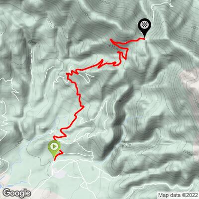
From Agios Athanasios the climb is 9.9 km (6.1 mi) with 792 m (2599 ft) of gain at a 7.6% average, from about 195 m (640 ft) to about 948 m (3110 ft).
The first kilometer climbs at about 7% out of the village, then the second is almost flat - a breather you'll want later. From there the slope barely changes: about 7.9 km at roughly 8.4%, with kilometers of 9.5-10% through the middle of the climb between km 3 and km 7.
The steepest 0.5 km is 11.8%, the steepest kilometer 10.8%, the steepest 2 km 10.0% and the steepest 5 km 9.2%. The final kilometer eases to about 6% onto the high point of the road.
Roadway: Fully paved and wider than most Greek mountain roads, with two lanes and a painted center line. The asphalt is cracked and patched in places, with gravel and rock debris on the edges below the cuttings near the top. The upper road is exposed and can see snow in winter, so check conditions locally outside the warmer months.
Traffic: Light. The road serves Glyfada and a few hamlets on the far side of the mountain, so expect the occasional local car and not much else.
Parking: Park in Agios Athanasios near the village football pitch, where hikers leave cars for the Agali gorge trail, and ride the short way north to the start. Keep the narrow village streets clear.
Gear: Nearly 8 km at about 8.5% is a long time in your lowest gear, so fit a compact and a cassette with at least 30 teeth. The upper half is open to sun and wind, so take sun protection in summer and a layer for the descent.
Provisions: Fill your bottles at the springs by the entrance to Agios Athanasios before you start; there's nothing on the climb itself. For a proper meal, the mountain village of Steni has tavernas around a square shaded by plane trees, a short drive east via Loutsa.
Before heading out on any cycling adventure check out our Things to Bring on a Cycling Trip and use our interactive check list to ensure you don't forget anything.
Chalkida, about 45 minutes away by car, is the nearest town with a full range of hotels, and Athens is under two hours. For a mountain base, Steni sits on the southern slopes of Dirfys among chestnut and fir, with tavernas, rooms and the trailheads for the summit.
Off the bike, the Agali gorge starts at Agios Athanasios - an easy to moderate 6 km walk up a stream under old plane trees, past springs, to a picnic area at Kratia. Riders who want more can carry on over the top and down to Glyfada.
ROUTE MAP
MEMBER RATING
CURRENT WEATHER
PJAMM TRIPS ADVENTURE STARTER BUNDLES
Check out PJAMM Adventure's prepackaged (self-guided) cycling trips. They will help you plan, document and conquer your next adventure.
NEARBY CLIMBS (0) RADIAL PROXIMITY
FROM No Climbs Found
MEMBER REVIEWS & COMMENTS
Let us know what you thought of this climb. Signup for our FREE membership to write a review or post a comment.
Already have an account?
LOG IN HERE
