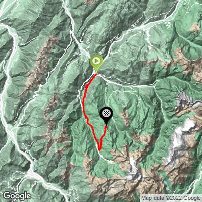
Sommet Tougnete Bike Climb - PJAMM Cycling

39.4
PDI
18.4 mi
DISTANCE
6,344 ft
GAINED
6.3 %
AVG. GRADE

FULL CLIMB STATS

Page Contributor(s): Ties Arts, Bussem, Netherlands; https://www.flickr.com/people/skifan

INTRO

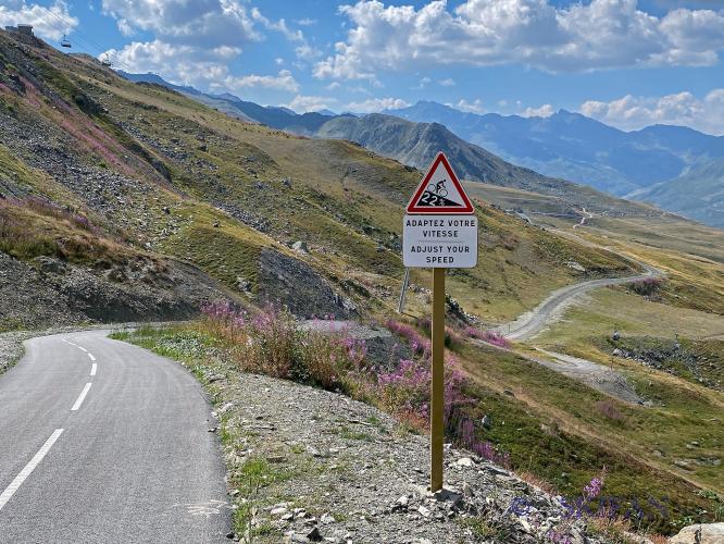
Photos on the climb summary are from Skifan - https://www.flickr.com/people/skifan

See more details and tools regarding this climb's grade via our interactive Profile Tool.
Information Not Available

If you have any information regarding this climb, we'd like to hear from you. Click the CONTRIBUTE button to share your thoughts with us.

Information Not Available

If you have any information regarding this climb, we'd like to hear from you. Click the CONTRIBUTE button to share your thoughts with us.

Before heading out on any cycling adventure check out our Things to Bring on a Cycling Trip and use our interactive check list to ensure you don't forget anything.
Information Not Available

If you have any information regarding this climb, we'd like to hear from you. Click the CONTRIBUTE button to share your thoughts with us.

ROUTE MAP

MEMBER RATING

Not Yet Rated
-
Road
-
Traffic
-
Scenery

CURRENT WEATHER

PJAMM TRIPS ADVENTURE STARTER BUNDLES

Check out PJAMM Adventure's prepackaged (self-guided) cycling trips. They will help you plan, document and conquer your next adventure.
ALL TRIPS
Browse all of our prepackaged trips and find your next adventure!

NEARBY CLIMBS (0) RADIAL PROXIMITY

FROM
No Climbs Found

MEMBER REVIEWS & COMMENTS

Let us know what you thought of this climb. Signup for our FREE membership to write a review or post a comment.
Already have an account?
ROUTE MAP
PROFILE TOOL
Route Data
S.G. (%)
hide
Segment Data
hide

Climb Profile Not Found
CLIMB SUMMARY

Sommet Tougnète

Featured image (see below) and text below featured image

Text on featured image:   Monster Climb with sommet on Via 3 Vallees

Page Contributor(s): Ties Arts, Bussum, Netherlands;  Skifan from Netherlands/France/Switzerland

Wow, this is a nearly 30km climb in the heart of the French Alps. It is in the world's largest ski area, Les Trois Vallees. From Moutiers to Les Menuires up to the Sommet Tougnète, 2437 meters altitude, and the last 6,7km it is a ‘piste cyclo’ meaning a paved cycling path just for cyclists. Above the tree line you have the mountain for yourself. And the last 400 meter are the toughest with a 22% section, are you ready for this? This climb is ranked among the hardest bike climbs in France.

FULL SUMMARY

Sommet Tougnète at 2437 meters was recently paved (autumn 2021) as part of a cycling project in the world's largest ski area: Les Trois Vallees. Sommet Tougnète is connecting Les Menuires with Meribel, though the climb from Meribel is not yet in place and expected to be done in 2023. So for now it is a dead-end climb.

Via 3 Vallees

The bigger project of the Tougnète climb is that the three vallees and its famous ski villages Courchevel, Meribel, Les Menuires and Val Thorens are connected with paved roads just like it is with ski’s, welcome to project Via 3 Vallees. The connecting roads are only accessible with bikes and that makes it unique. Courchevel and Meribel are connected with col de la Loze since 2019 (and had its Tour de France finish in 2020),  Les Menuires and Val Thorens are also connected with a cycling only road (piste cyclo as the French name it). Meribel and Les Menuires are connected only from the Les Menuires side and that’s why it's called Sommet Tougnète and not Col de la Tougnète yet. In 2023 it is expected to be finished and then you can cycle through all the three vallees via the piste cyclo.

Sommet Tougnète is comparable with the Col de la Loze from Meribel for the piste cyclo only (and for the longer version from Brides-les Baides).

6,7km is the piste cyclo from Les Menuires and just like the col de la Loze it is a climb with grades hitting 18% or more. The piste cyclo is very unstable and has very steep and relatively flat sections which makes the climb more difficult. Especially if you take the long version down from the valley. (Moutiers).

This is France's 3rd toughest climb after Col de la Loze and Col de Portet.

The climb starts where the road D96 starts, just outside Moutiers. This is where the true climbing starts.  It is a quiet road (and less busy than the D117).  Many hairpins on the D96 and after 12,1km you enter the D117. In les Menuires at the iconic Brelin-building (square building) area at km 23 of the climb the piste cyclo starts. No more cars or motorbikes. Just bikes (race and MTB). 8.5% average is the cycling path. But this is a roller. It is not a continuous climb, quite the opposite. Continuous change of percentages. That hurts more!

See the piste cyclo movie by skifan:  

The start of piste cyclo.

The first couple of hundred meters after the start near the Brelin building

Just above Brelin building

Heading towards restaurant le grand Lac

Panoramic view piste cyclo from restaurant le grand Lac up to restaurant Altitude.

The steep section to restaurant Altitude (nearby sommet Tougnète)

The last few hundred meters with 22% section looking from the sommet

And now by drone the last super steep part (400m for 19%), man that hurts!

The Sommet Tougnète is 2437 meters above sea level.