
21.4
PDI
7.6 mi
DISTANCE
3,081 ft
GAINED
7.7 %
AVG. GRADE
FULL CLIMB STATS
INTRO
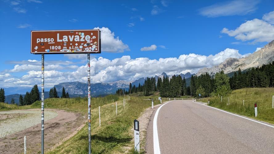
Passo Lavazè (Lavazèjoch) is a 1808 m (5,932 ft) pass in the Latemar group of the Dolomites, linking South Tyrol's Eggental with Cavalese and the Val di Fiemme in Trentino. From Ponte Nova (Birchabruck) our route covers 12.2 km (7.6 mi) and 939 m (3,081 ft) of climbing at an average of 7.7%, starting at 881 m (2,890 ft) and finishing on the high plateau.
There are few flat sections to recover on: even the steepest 10 km averages 8.3%, and the steepest kilometer averages 12.0%. The reward is the plateau at the top, where the road opens out beside a small lake and restaurant with views of the Latemar and Catinaccio massifs.
Although the border between South Tyrol and Trentino lies lower on the road, the pass itself sits entirely in Trentino. In winter the plateau becomes a major cross-country ski center with about 80 km of trails, and it has been used to train Olympic cross-country skiers ahead of the 2026 Milan-Cortina Games.
PLAN YOUR ROUTE
 We've partnered with Sherpa-Map.com to bring you the best route planning tool. With a PRO Membership you can use this climb as a reference when creating your route.
 The climb averages 7.7% over 12.2 km (7.6 mi), gaining 939 m (3,081 ft). The steepest 500 m averages 14.7%, the steepest kilometer 12.0%, the steepest 2 km 11.1%, and the steepest 5 km 9.3%. There is also a short pitch of 18.2% over 100 yd (91 m). Even the steepest 10 km averages 8.3%, so there is almost no flat until the plateau. A compact crankset is wise.
Roadway: The climb follows the paved SP 620, which runs from Ponte Nova over the pass to Cavalese. The road condition is good throughout. The pass is normally open all year, with occasional short winter closures in dangerous weather. If you plan to continue to Passo Oclini (1,990 m / 6,529 ft), the 2.7 km Trentino section of that link road was completely resurfaced in a project scheduled to finish in October 2025.
Traffic: Traffic is generally moderate. Articulated lorries and trucks with trailers are prohibited between the pass and Cavalese, which keeps heavy traffic off the road.
Parking: Start from the village of Ponte Nova, following local parking signs. At the top, the pass has a small lake and restaurant, and the Nordic ski center sits on the same plateau.
Provisions: The small lake at the top has a restaurant; carry water for the climb itself and fill up in Ponte Nova before you start.
Gear: You finish about 930 m (3,050 ft) above the start on an open plateau, so pack a layer for the descent. Snow can linger on the plateau into spring because it is used for cross-country skiing.
Before heading out on any cycling adventure check out our Things to Bring on a Cycling Trip and use our interactive check list to ensure you don't forget anything.
Ponte Nova is in Nova Ponente, about 30 km (19 mi) southeast of Bolzano, on the Karerpass road. The same junction is the start of our Passo Costalunga/Karerpass climb, so Lavazè and Karerpass pair naturally as two days from one base. The other side of the pass descends to Cavalese and the Val di Fiemme; see our Passo Lavaze (Cavalese) page for that approach.
For a base on this side, Obereggen is the small ski village (about 900 residents) at the foot of the Latemar in Nova Ponente. Non-cyclists in your group can hike from Obereggen to the pass (15.2 km, about 627 m of climbing), and cyclists with energy left can continue from the pass on an easy road to Passo Oclini. Our Routes in the Area tool shows the many other Dolomite climbs within reach of Ponte Nova.
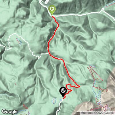
ROUTE MAP
MEMBER RATING
CURRENT WEATHER
PJAMM TRIPS ADVENTURE STARTER BUNDLES
Check out PJAMM Adventure's prepackaged (self-guided) cycling trips. They will help you plan, document and conquer your next adventure.
NEARBY CLIMBS (0) RADIAL PROXIMITY
FROM No Climbs Found
MEMBER REVIEWS & COMMENTS
Let us know what you thought of this climb. Signup for our FREE membership to write a review or post a comment.
Already have an account?
LOG IN HERE
