
27.4
PDI
16 mi
DISTANCE
4,963 ft
GAINED
5.7 %
AVG. GRADE
FULL CLIMB STATS
INTRO
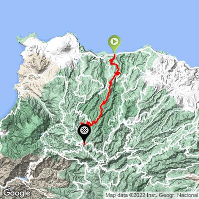
Moya - Pinos de Gáldar climbs from sea level at El Pagador, on Gran Canaria's green north coast, up to the pine forests of the island's central highlands - 25.8 km (16.0 mi) at an average grade of 5.7% for 1513 m (4,963 ft) of gain. It's currently ranked in the top 500 hardest climbs in the world.
The route follows the GC-75 out of El Pagador and climbs steadily to Moya, a hillside town perched between the Barranco de Moya and Barranco de Azuaje with a stone balcony at its church offering sweeping views back down to the coast - and the birthplace of Gran Canaria's best-known poet, Tomás Morales.
From Moya the road continues climbing through Fontanales toward the Pinos de Gáldar, a grove of centuries-old Canary pines ringing a volcanic caldera near the Montañón Negro cone, finishing at 1,490 m (4,890 ft) among some of the last old-growth pine forest on the island.
This is one of several routes up through Gran Canaria's lush, green north side, a sharp contrast to the arid south and west of the island - expect dense laurel and pine forest, cooler air, and cloud cover rolling in off the Atlantic the higher you climb.
PLAN YOUR ROUTE
 We've partnered with Sherpa-Map.com to bring you the best route planning tool. With a PRO Membership you can use this climb as a reference when creating your route.
 Moya - Pinos de Gáldar gains 1,513 m (4,963 ft) over 25.8 km (16.0 mi) for an average grade of 5.7%. The climb isn't uniformly steep - the hardest kilometer averages 10.9%, well above the overall average, while the toughest 2.5 mi stretch settles to 8.7% and the full 5 mi split eases to 6.3%, reflecting a route with real pitches mixed among gentler, rolling sections.
Most of the sustained climbing comes on the GC-75 between El Pagador and Moya and again above Fontanales, with the final approach to the Pinos de Gáldar leveling out somewhat as the road nears the high pine forest at 1,490 m (4,890 ft).
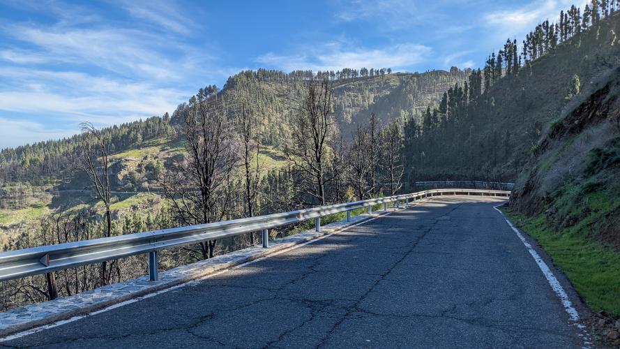
Roadway: The entire route is paved, following the GC-75 from the coast at El Pagador up through Moya and Fontanales, where it connects with the GC-70 for the final approach to the Pinos de Gáldar. The road surface has been reported in good condition on recent rides through this part of northern Gran Canaria. As with most mountain roads on the island, conditions can change quickly with weather - the upper sections occasionally see reduced visibility from cloud cover rolling in off the Atlantic, so check conditions before heading up on a day with unsettled weather.
Traffic: Traffic is light to moderate through Moya and Fontanales, both small local towns, and thins out further as the road climbs into the pine forest near the top. This is a quieter alternative to some of Gran Canaria's more heavily-trafficked central mountain roads, though it's popular with local drivers heading up to the Pinos de Gáldar viewpoint on weekends.
Parking: Free street parking is available in El Pagador near the coastal GC-2 junction, and again in Moya if you'd rather start partway up and skip the flatter coastal approach. There's also parking at the Pinos de Gáldar / Mirador Astronómico area near the top for anyone driving up to meet riders or explore on foot.
Bring layers - this climb runs from warm, humid coastal air at El Pagador to noticeably cooler, often cloud-wrapped pine forest above 1,400 m, and Gran Canaria's north side is prone to quick weather changes even in summer. A compact crankset is worth having for the steeper pitches through Moya and above Fontanales, where the grade briefly exceeds 10%, even though the overall average is a manageable 5.7%.
Moya has shops and cafes for a final stock-up before the road quiets down into the mountains, so it's realistic to travel light rather than carrying a full day's food and water from the coast.
Before heading out on any cycling adventure check out our Things to Bring on a Cycling Trip and use our interactive check list to ensure you don't forget anything.
Moya, roughly a third of the way up, is worth a stop in its own right - a hillside town wedged between two ravines with a stone balcony at its church offering one of the best coastal panoramas on this side of the island, plus the Casa Museo Tomás Morales, dedicated to the poet who was born there.
The town also borders Los Tiles de Moya, one of the last remnants of laurisilva (laurel forest) left on Gran Canaria, within the Parque Rural de Doramas. At the top, the Pinos de Gáldar caldera and its centuries-old Canary pines are a genuinely unique sight - these trees survived clearances that cleared most of the island's other old-growth forest.
Gran Canaria's interior has plenty of other climbs worth combining with this one; see what's nearby with our Routes in the Area tool.
ROUTE MAP
MEMBER RATING
CURRENT WEATHER
PJAMM TRIPS ADVENTURE STARTER BUNDLES
Check out PJAMM Adventure's prepackaged (self-guided) cycling trips. They will help you plan, document and conquer your next adventure.
NEARBY CLIMBS (0) RADIAL PROXIMITY
FROM No Climbs Found
MEMBER REVIEWS & COMMENTS
Let us know what you thought of this climb. Signup for our FREE membership to write a review or post a comment.
Already have an account?
LOG IN HERE
