
19.9
PDI
14.5 mi
DISTANCE
3,931 ft
GAINED
4.9 %
AVG. GRADE
FULL CLIMB STATS
INTRO
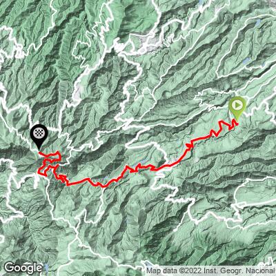
Santa Brígida - Cruz de Tejeda follows the Carretera del Centro, the old main road into the heart of Gran Canaria, from the wine country above Las Palmas to the island's central crossroads - 23.4 km (14.5 mi) with 1,198 m (3,931 ft) of gain at a 4.9% average grade, rising from 498 m (1,634 ft) to 1,636 m (5,366 ft).
This is a climb of steady rhythm rather than brute force. The GC-15 winds up through vineyards, orchards and terraced farmland to Vega de San Mateo, the market town at km 7 (4.3 mi), then on to the white houses of Las Lagunetas, where the road briefly flattens and even dips. The hardest riding comes last: the steepest kilometer (8.4%) sits in the final push through pine forest to Cruz de Tejeda, around 1,510 m (4,954 ft).
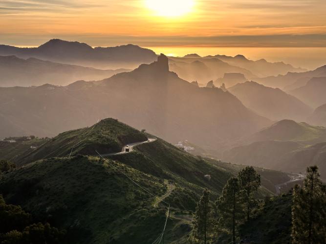
Most riders would stop at the stone cross, but this route keeps going for another 3.5 km (2.2 mi) on the GC-150, climbing gently to the road's high point below Alto de los Moriscos, with views over the Caldera de Tejeda to Roque Nublo and Roque Bentayga.
Storm Therese damaged many of the island's mountain roads in March 2026, and slope-stabilization work on the GC-15 has continued through the summer - see Roadway & Parking before you go.
PLAN YOUR ROUTE
 We've partnered with Sherpa-Map.com to bring you the best route planning tool. With a PRO Membership you can use this climb as a reference when creating your route.
 The climb covers 23.4 km (14.5 mi) at an average of 4.9%, gaining 1,198 m (3,931 ft) from 498 m (1,634 ft) in Santa Brígida to 1,636 m (5,366 ft) on the GC-150 above Cruz de Tejeda. The steepest kilometer averages 8.4%, the steepest 2 km 7.8%, and the steepest 5 km 6.6%.
The first 13 km (8.1 mi) are remarkably consistent, holding mostly between 4% and 7% as the road climbs through Vega de San Mateo (about 840 m / 2,756 ft at km 7) to Las Lagunetas (about 1,220 m / 4,003 ft at km 13).
Beyond Las Lagunetas the road rolls for roughly 2 km, losing about 30 m (98 ft), before the real work begins: kilometers 16 through 20 average close to 7% and include the steepest section of the climb, up to Cruz de Tejeda at around km 19.9 (12.4 mi).
The final 3.5 km (2.2 mi) on the GC-150 are the gentlest of the day, averaging about 3.6% for 125 m (410 ft) of gain to the finish.
Roadway: Paved the entire way. The GC-15 is a winding two-lane mountain road with generally good asphalt, narrowing in places through the villages, while the final stretch on the GC-150 above Cruz de Tejeda is narrower still. Storm Therese (19-26 March 2026) caused rockfalls and slope damage across the island's high roads, and the Cabildo de Gran Canaria listed the GC-15 among the roads needing slope-stabilization work, walls and rockfall mesh - expect occasional short daytime closures or alternating one-way traffic, and check the Cabildo's road notices before you go.
Traffic: Moderate to busy for the first half of the climb - the GC-15 is the main commuter road between Las Palmas, Santa Brígida and Vega de San Mateo, and weekend market traffic in San Mateo adds to it. Above Las Lagunetas it becomes quieter, though Cruz de Tejeda itself draws tour buses, motorcycles and sightseers, especially on weekends.
Parking: Santa Brígida is a compact hillside town with street parking around its historic center, a few minutes' ride from the start. To shorten the ride, start from Vega de San Mateo at km 7. At the top, the plaza at Cruz de Tejeda has parking but fills quickly on sunny weekends.
Provisions: Santa Brígida and Vega de San Mateo both have bakeries, cafes and supermarkets, and San Mateo's weekend market is a good place to pick up fruit, cheese and bread on the way through. Las Lagunetas, at about km 13, has traditional Canarian restaurants near its church - the last real stop before Cruz de Tejeda, where several restaurants and cafes and the Parador cluster around the plaza. There's nothing past Cruz de Tejeda on the final stretch to the finish.
Gear: The north side of the island is often wrapped in trade-wind cloud between San Mateo and the summit even when the coast is sunny, so bring a rain shell and arm warmers. The top sits above 1,600 m, and the long descent back to Santa Brígida can be cold. A compact crankset is plenty for the grades here.
Before heading out on any cycling adventure check out our Things to Bring on a Cycling Trip and use our interactive check list to ensure you don't forget anything.
This is the climb that delivers you straight to Cruz de Tejeda, so take time at the top. The dark stone cross marks the crossroads where roads from every part of the island meet, and the Parador de Cruz de Tejeda beside it - our favorite base on the island - has terraces and an open-air hydrothermal pool looking over the Caldera de Tejeda, the landscape Miguel de Unamuno called a "petrified storm." From here Roque Nublo and Roque Bentayga rise out of the Risco Caído and Sacred Mountains cultural landscape, a UNESCO World Heritage Site since 2019, and on clear days Mount Teide appears across the water on Tenerife. The village of Tejeda, known for its almond sweets, is about ten minutes' drive away.
On the way up, time your ride for the Mercado Agrícola y Artesanal in Vega de San Mateo, open Friday through Sunday (Saturdays 8:00-20:00, Sundays until 15:00). Back at the start, Santa Brígida is the heart of the Monte Lentiscal wine district and home to the Casa del Vino de Gran Canaria, and the island's oldest dragon tree, the Drago de Barranco Alonso, grows on a cliff just outside town.
Cruz de Tejeda is also reached by several other PJAMM climbs - see what's nearby and plan combinations with our Routes in the Area tool.
ROUTE MAP
MEMBER RATING
CURRENT WEATHER
PJAMM TRIPS ADVENTURE STARTER BUNDLES
Check out PJAMM Adventure's prepackaged (self-guided) cycling trips. They will help you plan, document and conquer your next adventure.
NEARBY CLIMBS (0) RADIAL PROXIMITY
FROM No Climbs Found
MEMBER REVIEWS & COMMENTS
Let us know what you thought of this climb. Signup for our FREE membership to write a review or post a comment.
Already have an account?
LOG IN HERE
