
24.3
PDI
17 mi
DISTANCE
4,692 ft
GAINED
4.9 %
AVG. GRADE
FULL CLIMB STATS
INTRO
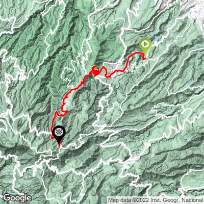
This route climbs from Teror, the pilgrimage town at the heart of Gran Canaria's lush north, all the way to Pico de las Nieves, the island's highest point - 27.3 km (17.0 mi) with 1,430 m (4,692 ft) of gain at a 4.9% average grade, topping out at 1,936 m (6,351 ft).
It's a long, steady climb rather than a savage one. The GC-21 leaves Teror at a consistent 4-7% and winds up through Valleseco - whose name means "dry valley," though it's one of the wettest municipalities on the island and is often wrapped in a sea of cloud carried in by the trade winds - past the Balcón de Zamora viewpoint and the hamlets of Lanzarote and Cuevas del Corcho. At Cruz de Tejeda, the island's central crossroads, the grade eases and even dips briefly before the GC-150 and GC-130 carry you up through pine forest, where the steepest kilometer (9.9%) waits about 5 km from the top.
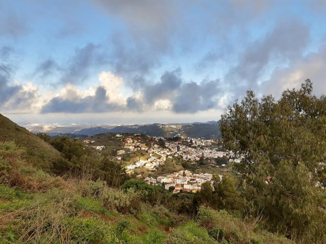
Pico de las Nieves means "peak of the snows," named for the covered snow pits built into its slopes from 1694 onward, when laborers packed winter snow to be hauled down to Las Palmas in summer. The true summit is a fenced military installation; the public viewpoint just below it looks across the island to Roque Nublo and, on clear days, Tenerife's Mount Teide.
PLAN YOUR ROUTE
 We've partnered with Sherpa-Map.com to bring you the best route planning tool. With a PRO Membership you can use this climb as a reference when creating your route.
 This route gains 1,430 m (4,692 ft) over 27.3 km (17.0 mi) at an average grade of 4.9%, from 601 m (1,973 ft) in Teror to 1,936 m (6,351 ft) at the Pico de las Nieves viewpoint.
The first 15 km, up the GC-21 through Valleseco, hold remarkably steady at 4-7%, with only one kilometer creeping above 8%. Around Cruz de Tejeda the road flattens and loses a little height, and there's one more short dip a few kilometers later - 96 m (314 ft) of descent in total. The hardest climbing comes near the end on the GC-130 and GC-134: the steepest kilometer averages 9.9% and the steepest 500 meters 11.1%, while the steepest 2 km (7.8%) and 5 km (6.8%) both fall in the final third.
Roadway: Paved the entire way - the GC-21 from Teror through Valleseco to Cruz de Tejeda, then the GC-150, GC-130 and the short GC-134 spur to the summit. The GC-21 is a winding two-lane mountain road in generally good condition. It closes or goes one-way for big local events: the Fiestas del Pino around 7-8 September, Valleseco's pilgrimage to Teror, and rally stages (it was closed for the Rally Islas Canarias in April 2026). The high roads around the summit plateau can also close briefly in winter for ice, so check conditions before an off-season ride.
Traffic: Moderate in and around Teror, which sits within the Las Palmas urban area, then lighter through Valleseco and the upper GC-21. Expect a bump in cars, tour buses and motorcycles at Cruz de Tejeda, one of the island's most visited stops, and on the summit road on weekends when sightseers drive up for the view.
Parking: Teror's municipal Los Perales car park in the historic center has around 100 free spaces. The town gets busy on Sunday mornings with the weekly market, so arrive early or plan around it. Parking at the Pico de las Nieves viewpoint is small and fills on clear weekends.
Provisions: Teror has bakeries, cafes and shops for a pre-ride stock-up. Valleseco and the Balcón de Zamora restaurant on the GC-21 between Teror and Valleseco are early options, and Cruz de Tejeda, roughly two-thirds of the way up, has restaurants and cafes and is your last dependable stop - there's nothing reliable on the final 9 km to the summit.
Gear: Bring layers. The north side of the island is often damp and cloudy through Valleseco even when the south coast is sunny, and the summit at nearly 2,000 m can be cold and windy, especially on the descent. The grade is steady enough that standard compact gearing is plenty for most riders.
Before heading out on any cycling adventure check out our Things to Bring on a Cycling Trip and use our interactive check list to ensure you don't forget anything.
Teror is worth a slow wander before or after the ride. Its Basílica de Nuestra Señora del Pino honors the Virgin of the Pine, patron of Gran Canaria, after a reported Marian apparition here on 8 September 1481 - which made Teror the island's most important pilgrimage destination. The Fiesta del Pino around 8 September is its biggest event of the year. The old center, under monument protection, is lined with white houses and carved wooden balconies along Calle Real de la Plaza.
Come on a Sunday and the streets beside the basilica fill with a market tradition more than two centuries old. Look for chorizo de Teror, a soft, spreadable paprika-and-garlic pork sausage that's the town's signature food, plus cheeses from the surrounding highlands. A few kilometers up the road, Valleseco is Gran Canaria's apple and cider country and holds an annual apple and cider food festival.
Teror is also the start of our Teror - Cueva Grande climb, and Pico de las Nieves can be reached from several other towns around the island - see what's nearby and plan combinations with our Routes in the Area tool.
ROUTE MAP
MEMBER RATING
CURRENT WEATHER
PJAMM TRIPS ADVENTURE STARTER BUNDLES
Check out PJAMM Adventure's prepackaged (self-guided) cycling trips. They will help you plan, document and conquer your next adventure.
NEARBY CLIMBS (0) RADIAL PROXIMITY
FROM No Climbs Found
MEMBER REVIEWS & COMMENTS
Let us know what you thought of this climb. Signup for our FREE membership to write a review or post a comment.
Already have an account?
LOG IN HERE
