

24.6
PDI
12.9 mi
DISTANCE
4,251 ft
GAINED
6.2 %
AVG. GRADE
FULL CLIMB STATS
INTRO
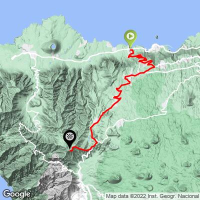
El Tanque climbs 20.8 km (13 mi) from the coast near Las Cruces, on Tenerife's northwest shore, up through the town of El Tanque and the hamlet of Erjos toward the edge of Teide National Park. It gains 1296 m (4,251 ft) at a 6.2% average grade, finishing at 1341 m (4,400 ft).
The lower kilometers climb steadily away from the coast with Atlantic views behind you, working through a mid-section of tighter switchbacks before the road eases into the gentler, more open highland terrain around Erjos. The gradient isn't uniform: the steepest kilometer averages a demanding 14.2%, with a maximum ramp near 18.1%, concentrated in the lower-to-middle part of the climb, while the upper miles settle into a much gentler grind.
El Tanque, the town that gives the climb its name, takes its name from a water tank built by early European settlers in the 16th century. It sits in an area shaped by the 1706 eruption of the Trevejo volcano, which erupted for forty days and buried the harbor of nearby Garachico - at the time Tenerife's principal trading port with Europe and the Americas - ending the town's golden age and shifting the island's maritime trade elsewhere for good.
Near the top of the climb, the Charcas de Erjos - a small cluster of rain-fed lagoons within the Parque Rural de Teno - are one of the Canary Islands' few wetland habitats, drawing more than fifty species of migratory birds during passage and winter months.
PLAN YOUR ROUTE
 We've partnered with Sherpa-Map.com to bring you the best route planning tool. With a PRO Membership you can use this climb as a reference when creating your route.
 This climb covers 20.8 km (12.9 mi) and gains 1,296 m (4,251 ft) at a 6.2% average grade, finishing at 1,341 m (4,400 ft).
The effort is front-and-mid-loaded: the steepest kilometer averages 14.2%, the steepest half-mile 15.4%, and the single steepest ramp reaches 18.1%, all concentrated in the switchback section below El Tanque and Erjos. The trailing 5 km average eases to 7.1% and the trailing 10 km to 6.3%, reflecting a much gentler upper section as the road levels out into the highland terrain near the top.
Roadway: Paved for the entire climb. The lower and middle sections through the switchbacks below El Tanque are narrower with tighter corners, while the upper stretch past Erjos widens out and mellows considerably as the terrain flattens into highland pasture.
Traffic: Light to moderate on the lower coastal approach near Las Cruces and through El Tanque itself, where the road serves local traffic and through-traffic toward the Teno area; noticeably quieter above Erjos, which sees mostly local and outdoor-recreation traffic.
Parking: Free roadside parking is available around Las Cruces near the base of the climb, and again in El Tanque's town center if you'd rather split the ride or start partway up.
Compact or wide-range gearing is worth having for the steep switchback section below El Tanque, where sustained pitches reach into the mid-teens - the upper miles past Erjos are far gentler by comparison.
El Tanque has shops, bars, and restaurants for stocking up partway through the climb, and Las Cruces and the surrounding coastal towns (Garachico, Buenavista del Norte) have fuller services at the base. There's little in the way of services in the highlands above Erjos, so top off water before continuing past the village.
Before heading out on any cycling adventure check out our Things to Bring on a Cycling Trip and use our interactive check list to ensure you don't forget anything.
Garachico, a few kilometers from the base of this climb, is worth the detour - it was Tenerife's main trading port until the 1706 Trevejo eruption buried its harbor in lava, and the town has since rebuilt around that history, with a walkable historic center and natural volcanic-rock swimming pools formed by the same lava flow.
Buenavista del Norte, on the other side of El Tanque, anchors the western end of the coast before the Teno cliffs take over.
Near the top of the ride, the Charcas de Erjos are a worthwhile stop for anyone interested in birdwatching - a rare wetland habitat for the Canary Islands, tucked into the Parque Rural de Teno, where dozens of migratory species pass through each winter.
El Tanque itself is a practical, unpretentious town rather than a resort, with everyday shops and restaurants for refueling mid-ride.
This climb sits within easy reach of Tenerife's other northwest ascents toward Teide National Park and the Teno massif - check PJAMM's Routes in the Area tool for other nearby climbs worth combining with a visit to this corner of the island.
ROUTE MAP
MEMBER RATING
CURRENT WEATHER
PJAMM TRIPS ADVENTURE STARTER BUNDLES
Check out PJAMM Adventure's prepackaged (self-guided) cycling trips. They will help you plan, document and conquer your next adventure.
NEARBY CLIMBS (0) RADIAL PROXIMITY
FROM No Climbs Found
MEMBER REVIEWS & COMMENTS
Let us know what you thought of this climb. Signup for our FREE membership to write a review or post a comment.
Already have an account?
LOG IN HERE
