
17.4
PDI
9.5 mi
DISTANCE
3,022 ft
GAINED
6 %
AVG. GRADE
FULL CLIMB STATS
INTRO
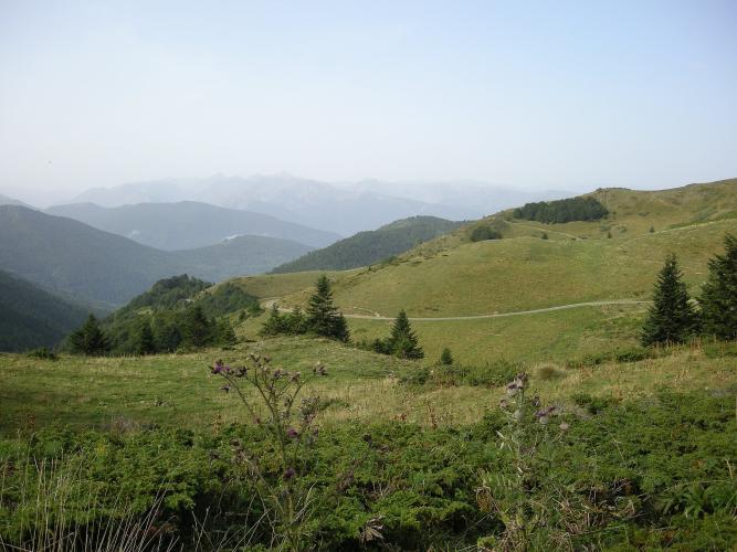
One rider on this road went almost 20 km without seeing a car, and that's not unusual. The D107 follows the Rebenty up a valley that most people never drive, through three small villages, before it climbs into the forest and pops out on the open pastures of the Col du Pradel at about 1681 m, with the Port de Pailhères off to the left.
It's 15.2 km (9.5 mi) and 921 m (3022 ft) of climbing, but the 6.0% average is misleading in a useful way. The first 5 km, below the scant ruins of the Niort-de-Sault castle, barely tilt - 2-4% along the river. It starts to climb in earnest after Mérial, and after La Fajolle it's 7 km at close to 8%, almost all under trees, with a couple of short ramps near 12%.
Riders love it for the quiet and the shade, and complain about the surface. It's a narrow single-lane road, under 3 m wide in places, with patched sections and some gravel. Near the top there's a rust-red waterfall, and the last bends cross open grassland where cows wander the road. If you only know the Ax-les-Thermes side, this is the longer, gentler and lonelier way up.
PLAN YOUR ROUTE
 We've partnered with Sherpa-Map.com to bring you the best route planning tool. With a PRO Membership you can use this climb as a reference when creating your route.
From the Rebenty valley to the col, the climb is 15.2 km (9.5 mi) with 921 m (3022 ft) of gain at a 6.0% average, from about 775 m (2542 ft) to about 1681 m (5514 ft).
The first 5 km along the river through Niort-de-Sault average under 3.5%, and the next 3 km past Mérial build to 5.5-6.5%. The real climb starts around La Fajolle at km 8: from there to the col it's about 7 km at close to 8%, with kilometers of 8.5-9.5% broken by two short easings to about 6%.
The steepest 5 km average 8.3%, the steepest 2 km 9.0%, the steepest kilometer 11.1% and the steepest 0.5 km 12.6%. Riders describe a short ramp of about 12% around La Fajolle - it's steady climbing from there, with the last few hundred meters easing onto the col.
Roadway: Paved, narrow and single-lane - under 3 m wide in places, with a short rocky narrows above the river low on the climb. Rider reports describe a patched surface with potholes and loose gravel, more so on the descent, so treat it as a road for careful riding both ways. Snow closes the col in winter; check the Aude department's road information before riding outside summer.
Traffic: Very light. Many riders see one car or none between La Fajolle and the col. Cattle grazing on and around the road near the top are a bigger hazard than vehicles.
Parking: There's no car park at the start. Park considerately in Niort-de-Sault, about 2.5 km up the valley, or at the foot of the roads up to Espezel and Galinagues where the climb begins, without blocking farm access. Don't count on space in Mérial or La Fajolle.
Gear: The first 8 km are warm-up, then it's 7 km near 8% with ramps toward 12%, so a compact with a 30-tooth cog is about right. The road is mostly shaded and the summit pastures are open and windy - carry a layer, especially if you're going over the top toward Ax.
Provisions: La Fajolle has a roadside water point, and that's the only refill on the climb. There are no shops in the upper Rebenty villages, so bring food for the whole ride. The nearest proper shops are a drive away, in Ax-les-Thermes over the col or down the valley toward Axat.
Before heading out on any cycling adventure check out our Things to Bring on a Cycling Trip and use our interactive check list to ensure you don't forget anything.
This is the Pays de Sault: a high, thinly populated plateau of forest and pasture between the Aude and Ariège. The Niort-de-Sault castle, on a rocky spur above the village, was held by the Niort family, Cathar sympathizers who were among the last in the region to give in to the French crown, in 1255. Today only overgrown walls and a stair cut into the rock remain.
Pradel pairs naturally with the Port de Pailhères: over the top, the D25 drops to Ascou and Ax-les-Thermes, and our Col de Pradel (Ax-les-Thermes) and Pailhères pages cover that side and the town. Back on this side, the short Galinagues and Espezel climbs start at the foot of this one and go up onto the plateau. Downstream, the D107 runs through the Rebenty gorges and the Défilé de Joucou, a road cut through the rock with tunnels, if you want to make a big loop of it.
ROUTE MAP

MEMBER RATING
CURRENT WEATHER
PJAMM TRIPS ADVENTURE STARTER BUNDLES
Check out PJAMM Adventure's prepackaged (self-guided) cycling trips. They will help you plan, document and conquer your next adventure.
NEARBY CLIMBS (0) RADIAL PROXIMITY
FROM No Climbs Found
MEMBER REVIEWS & COMMENTS
Let us know what you thought of this climb. Signup for our FREE membership to write a review or post a comment.
Already have an account?
LOG IN HERE
