
19.2
PDI
9.1 mi
DISTANCE
3,139 ft
GAINED
6.6 %
AVG. GRADE
FULL CLIMB STATS
INTRO
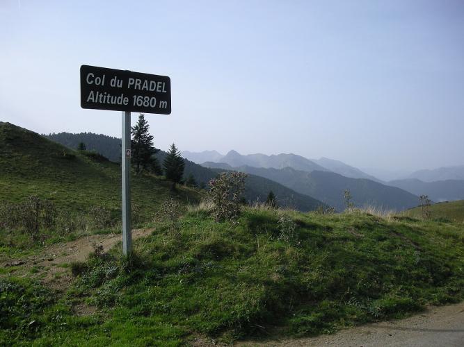
Col de Pradel's western side climbs 14.6 km (9.1 mi) from the spa town of Ax-les-Thermes to the col at 1681 m (5515 ft), gaining 957 m (3139 ft) at a 6.6% average. It's a climb of two halves. The first 7 km (4.3 mi) are a gentle, rolling run up the valley through Ascou and past the Goulours lake, on the same road as Col de Pailhères, and then the real Pradel begins.
At Lavail the Pailhères road carries straight on, and Pradel turns off onto a far narrower road, a former track that was paved later and is barely wider than a car. It climbs hard through the trees: two steep hairpins lead into a long forested ramp up a side valley, a pleasant set of switchbacks follows, and the last 2 km (1.2 mi) ease off across open meadows with the col in sight. Expect cows on the road.
This is a quiet climb even by Ariège standards. Riders often report going up without seeing a car, and the summit pastures look out over the high peaks above Ax. It makes a wild alternative to the busier Chioula road, and over the top the road drops through the remote Pays de Sault toward Niort-de-Sault and the Rebenty gorges.
PLAN YOUR ROUTE
 We've partnered with Sherpa-Map.com to bring you the best route planning tool. With a PRO Membership you can use this climb as a reference when creating your route.
Pradel averages 6.6% over 14.6 km (9.1 mi), but that number hides how uneven it is. The first 6 km (3.7 mi) out of Ax-les-Thermes hold a steady 5-7%, and there's an almost flat kilometer near Lavail.
After the turn at Lavail, the final 7.6 km (4.7 mi) average 7.7%, and that's where all the hard numbers live. The steepest kilometer averages 9.8%, the steepest 2 km hold 9.2%, and the steepest 5 km average 8.4%. The grade is irregular, with short ramps around 15%, before the last 2 km (1.2 mi) settle back to about 6% across the summit meadows.
Roadway: The shared lower road from Ax-les-Thermes through Ascou is an ordinary two-lane secondary road. Above Lavail, the Pradel road is narrow and its surface is the weak point of the climb: rider reports through summer 2025 describe loose gravel, potholes and patching on the Ax side, which makes the descent the part to take seriously. On the far side, the stretch from the summit down to the first village toward Niort-de-Sault was newly resurfaced in 2025. Snow can close the col in winter, so check Ariège's Inforoute09 road information before heading up outside summer.
Traffic: Light through Ascou and very light above Lavail. The upper road carries little more than local and farm traffic, and cows grazing on and beside the road are more common than cars. The busiest part is the start in Ax-les-Thermes, which you share with traffic heading for Chioula, Pailhères and Ascou.
Parking: There's no dedicated parking for Pradel, so most riders start in Ax-les-Thermes, where the climb shares its start with Chioula and Pailhères (our Col de Pailhères West page covers parking at the south end of town). To skip the shared lower road you can start from Ascou or the Goulours lake instead, but these are small hamlets, so park considerately and keep farm gates and tracks clear.
Gear: Gear low. Riders who know this climb recommend at least a 34x30 for the irregular ramps above Lavail, and a 34x32 doesn't hurt. Wider tires (28 mm or more) and good brakes help on the rough, gravelly descent.
Provisions: Ax-les-Thermes has shops, bakeries and cafes. Ascou is a commune of around 110 people, and there's nothing for sale on the climb itself. Fill your bottles in town and carry food for the whole ride, especially if you plan to continue over the col into the Pays de Sault.
Before heading out on any cycling adventure check out our Things to Bring on a Cycling Trip and use our interactive check list to ensure you don't forget anything.
Ax-les-Thermes is the natural base for Pradel, and our Col de Pailhères West page covers the town's hotels and spas. One small thing worth knowing: the Bassin des Ladres on Place du Breilh in the town center is a public basin of hot spring water where anyone can soak tired feet for free. A listed historic monument since 1979, it takes its name from the lepers treated at Ax's old hospital, including soldiers returning from the Crusades.
On the climb, Ascou is a tiny mountain commune made up of the village and the hamlets of Goulours, Lavail and Pujal. The Étang de Goulours, where the Riu Caud joins the Lauze, is a good place for a breather on the gentle lower half.
From the col you can drop into the Pays de Sault toward Niort-de-Sault and the Gorges du Rebenty for a big loop, or pair Pradel with Pailhères from Ax. See other climbs nearby, or build a custom route from here, with our Routes in the Area tool.
ROUTE MAP

MEMBER RATING
CURRENT WEATHER
PJAMM TRIPS ADVENTURE STARTER BUNDLES
Check out PJAMM Adventure's prepackaged (self-guided) cycling trips. They will help you plan, document and conquer your next adventure.
NEARBY CLIMBS (0) RADIAL PROXIMITY
FROM No Climbs Found
MEMBER REVIEWS & COMMENTS
Let us know what you thought of this climb. Signup for our FREE membership to write a review or post a comment.
Already have an account?
LOG IN HERE
