
18
PDI
9.2 mi
DISTANCE
3,051 ft
GAINED
6.3 %
AVG. GRADE
FULL CLIMB STATS
INTRO
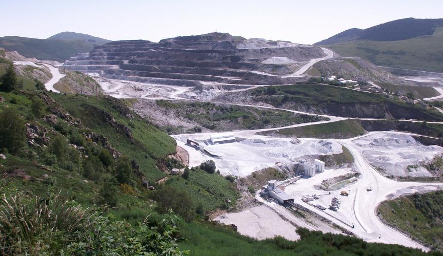
Few climbs end anywhere quite like this. The road from Luzenac climbs 14.7 km (9.2 mi) and 930 m (3051 ft) at a 6.3% average, from 609 m (1998 ft) in the upper Ariège valley to 1537 m (5043 ft) at the gates of the Carrière de Trimouns - the largest open-pit talc quarry in the world and the only working talc quarry in France. It ranks #1212 in the world in our database.
The lower half is a proper Pyrenean village climb, winding up to Lordat, where the ruins of an 11th-century castle sit on a rocky spur above the valley. Above the Marmare crossroads the character changes: the road was built for quarry trucks, so it is unusually wide and well surfaced for a mountain road, and riders describe it as something close to a motorway for bikes. The gradient is steady rather than savage - mostly 5-8%, with a few hairpins near 9% - and the views keep opening up across the valley toward Ax 3 Domaines and the Plateau de Beille.
The quarry itself sits higher still, above 1700 m (5577 ft). Talc was first gathered here by hand in the 19th century and carried down by mule, and the open pit has been worked since 1905, today producing around 400,000 tonnes a year. The road beyond the visitor entrance is closed to the public, but guided quarry tours run from spring to autumn. Quarry trucks use the road on weekdays, so this is best ridden on a weekend.
PLAN YOUR ROUTE
 We've partnered with Sherpa-Map.com to bring you the best route planning tool. With a PRO Membership you can use this climb as a reference when creating your route.
The climb gains 930 m (3051 ft) over 14.7 km (9.2 mi) at an average of 6.3%, and it is remarkably consistent from bottom to top.
The first kilometer out of Luzenac is the gentlest at about 4%, then the road settles into 6-7% on the climb to Lordat, with kilometer 4 at 7.2%. Past the village it eases to around 5% for a couple of kilometers before the two hardest sections of the climb: kilometer 8 at 8.2% and kilometer 10 at 8.1%, with tight hairpins where the grade briefly touches 9%.
The last 4 km (2.5 mi) are steadily easier, from 6.7% down to about 5% at the finish, though after a long climb that final stretch to the quarry entrance can feel longer than it looks.
The steepest 1 km (0.6 mi) averages 9.1%, the steepest 2 km (1.2 mi) 7.7%, and the steepest 5 km (3.1 mi) 7.2%. The steepest mile averages 7.8%.
Roadway: The road is paved the entire way. The first part out of Luzenac is a narrower village road, but above Lordat and especially past the Marmare crossroads it widens into a well-maintained road built for quarry trucks, and riders consistently describe the surface as very good. The final few hundred meters enter the quarry itself and are closed to general traffic - the climb finishes at the visitor entrance area.
Traffic: Light overall, but the quarry is a working industrial site and its trucks use the road on weekdays. Riders strongly recommend weekends - Sunday mornings are especially quiet - when the road is calm and you are as likely to meet other cyclists as cars.
Parking: Luzenac is a small valley village on the main N20, and riders typically start from the town hall in the village center - park considerately nearby. You can also arrive by train: Luzenac - Garanou station is served by TER trains from Toulouse via Foix and by the night train from Paris to Latour-de-Carol. For a shorter ride, the Château de Lordat has a free car park about a third of the way up.
Provisions: Fill up in Luzenac before you start - there are no shops on the climb. A drinks and snack vending machine is reported at the quarry's visitor area at the top, but it takes coins and is no substitute for carrying enough water.
Gear: The grade rarely exceeds 8%, so a standard compact crankset is plenty; pacing matters more than gearing on a climb this steady. The finish is more than 900 m (2953 ft) above the valley floor and riders have found the top in cloud on otherwise fine days, so bring a wind layer for the descent. If you plan to join a quarry tour, note that closed-toe shoes are mandatory.
Before heading out on any cycling adventure check out our Things to Bring on a Cycling Trip and use our interactive check list to ensure you don't forget anything.
Luzenac is a talc town through and through, and the Talcaneô museum on the main road through the village is the place to understand why - an interactive exhibition on how the "softest rock on the planet" goes from the mountain into everyday products. Guided 45-minute tours of the Trimouns quarry itself run on weekdays from spring to autumn (closed Wednesdays outside school holidays) and must be booked online, ideally on the day, as weather can cancel them at short notice.
The Château de Lordat, passed on the way up, has guarded the Ariège valley since the 11th century and sheltered Cathars during the Albigensian Crusade; its ruins at 965 m (3166 ft) have a viewing table for identifying the surrounding peaks. Visible early on the climb, the small Romanesque Église Sainte-Marthe in Vernaux, built of local tufa stone, has been a listed monument since 1910. For Tarascon-sur-Ariège and the Niaux cave paintings, see our Plateau de Beille page.
The Col de Marmare, the Route des Corniches and the Col de Pradel are all nearby - see other climbs nearby, or build a custom route from here, with our Routes in the Area tool.
ROUTE MAP

MEMBER RATING
CURRENT WEATHER
PJAMM TRIPS ADVENTURE STARTER BUNDLES
Check out PJAMM Adventure's prepackaged (self-guided) cycling trips. They will help you plan, document and conquer your next adventure.
NEARBY CLIMBS (0) RADIAL PROXIMITY
FROM No Climbs Found
MEMBER REVIEWS & COMMENTS
Let us know what you thought of this climb. Signup for our FREE membership to write a review or post a comment.
Already have an account?
LOG IN HERE
