
19.4
PDI
13.7 mi
DISTANCE
3,713 ft
GAINED
5.1 %
AVG. GRADE
FULL CLIMB STATS
INTRO
PLAN YOUR ROUTE
 We've partnered with Sherpa-Map.com to bring you the best route planning tool. With a PRO Membership you can use this climb as a reference when creating your route.
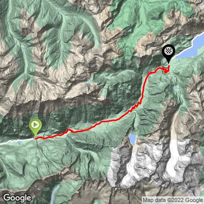
Maloja Pass from Castasegna averages 5.1% over 22.0 km (13.7 mi), gaining 1,131.7 m (3,713 ft).
The steepest 100 yards (91 m) reach 11.5%, the steepest 500 m averages 9.8%, the steepest kilometer 9.0% and the steepest 2 km 8.8%. The steepest 5 km averages 7.1% and the steepest 10 km 6.0%.
The hardest sustained work is the 13 hairpins above Casaccia, roughly 3 km (1.9 mi) at about 9%. A short flat stretch just before them lets you recover, and the final 10 km beyond the pass along the Engadin lakes is almost level.
Roadway: Paved the entire way on Swiss Route 3, which was rebuilt to roughly its present standard in 1957 and is kept open all year. Cyclists cannot use the tunnel that bypasses Promontogno, about 3 km (1.9 mi) into the climb; follow the signed detour of roughly 1.5 km (0.9 mi) through the village, where the narrow main street is cobbled. Just after the border, a rockfall-protection gallery leads into about 2 km (1.2 mi) at roughly 7%. Beyond the pass the road toward Sils has been prone to rockfall closures, and Graubünden has proposed an upgrade that includes a cycle path.
Traffic: Moderate. This is the main road between Lombardy and the Engadin, so expect cars, motorcycles and buses through the summer, thinning out on the upper climb. Heavy trucks with trailers are banned, which keeps the worst freight traffic off the road.
Parking: Castasegna is a small border village with a PostAuto stop at the old customs house. The Maloja-Bergell-Bregaglia PostAuto line carries bikes (a place for your bike has to be reserved in the May-October season), so you can ride up and bus back down the valley, or the reverse. If you are driving, the larger car parks and the railway station are in Chiavenna, 10 km (6.2 mi) down the valley - see our Passo del Maloja page.
Gear: A road bike with compact gearing suits the 9-10% hairpins. The pass is 1,129 m (3,704 ft) higher than the start, so bring a windproof layer for the descent, even in summer.
Provisions: The villages split the climb into short stages: Promontogno at 3 km (1.9 mi), Stampa at 6 km (3.7 mi) and Vicosoprano at 9 km (5.6 mi). A large filling station sits a few hundred meters before the Promontogno tunnel, a good last place to stock up on food and drink.
Before heading out on any cycling adventure check out our Things to Bring on a Cycling Trip and use our interactive check list to ensure you don't forget anything.
Castasegna sits at the start of what is described as Europe's largest sweet chestnut forest, and a chestnut educational trail begins in the village. In autumn the stone drying huts (cascine) send smoke up through the trees, and October brings the Festa della Castagna with guided walks, markets and tastings.
In Stampa, the Ciäsa Granda houses the Museum Bregaglia, with a section on the Giacometti family, and the sculptor Alberto Giacometti was born in Stampa. Palazzo Castelmur is also in the village. At the top, Maloja has the glacial potholes known as the Marmitte dei Giganti, the Torre Belvedere viewpoint, and the Segantini trail, which links places where the painter Giovanni Segantini spent his last years. The easy walk to Lago Cavloc, at about 1,900 m (6,234 ft), starts from the village.
Chiavenna's grotto restaurants, the Acquafraggia waterfalls and the Soglio detour are covered on our Passo del Maloja page. Check current conditions at the pass before you go with our Weather tool.
ROUTE MAP
MEMBER RATING
CURRENT WEATHER
PJAMM TRIPS ADVENTURE STARTER BUNDLES
Check out PJAMM Adventure's prepackaged (self-guided) cycling trips. They will help you plan, document and conquer your next adventure.
NEARBY CLIMBS (0) RADIAL PROXIMITY
FROM No Climbs Found
MEMBER REVIEWS & COMMENTS
Let us know what you thought of this climb. Signup for our FREE membership to write a review or post a comment.
Already have an account?
LOG IN HERE
