![]()
Cycling Chacaltaya
Ride 13 kilometers gaining 941 meters at 6.8% (9.3% climb only) to 5,245 meters (17,208’).
Note: Mountain bike required for this climb.
CHACALTAYA - EASTERN ROUTE
![]()
There are two routes to Chacaltaya. In this summary, we follow the route taken by Jeremiah Bishop and Tyler Pearce (The Vegan Cyclist) for their challenging Death Road + Chacaltaya Impossible Route (Strava; 88.5 kilometers gaining 4,707 meters ascended to 17,200’ elevation) . This route is more efficient when starting from the east if coming from the Death Road or Coroico. During our trip in May 2023, we took the southern route but encountered snow so we ended up hiking the last few miles (southern route; the final 4 kilometers of the southern and eastern approaches overlap at 9.2% and 452 meters gained). The southern route starts approximately 6 kilometers from La Paz, while the eastern approach begins about 22 kilometers away.
![]()
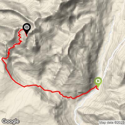
Google satellite view of the route and the climb finish.
Most of the photos for the eastern approach were taken by John Roszko and generously contributed to this page by our friend Jeremiah Bishop.
![]()
Climb begins on an unmarked dirt road of of Bolivia State Highway 41.
Chacaltaya is the name of a mountain in Bolivia, located in the Cordillera Real of the Andes mountain range. Its elevation is approximately 5,421 meters (17,785 feet) above sea level. While we do not make it all the way to Chacaltaya’s peak by bike, we do come within 40 meters of and can hike to it from the Refugio at the finish of the bike climb.
![]()
Presa Chacaltaya, commonly referred to as Chacaltaya, serves as a vital reservoir in the heart of South America, nestled in the breathtaking landscapes of Bolivia. Positioned approximately 27 kilometers away from the bustling capital city of La Paz, it plays an indispensable role within the La Paz Waterworks system. This reservoir is perched at a remarkable altitude of 4,470 meters (14,665 feet), serving as an important water source for La Paz and its surrounding regions.
![]()
Chacaltaya was home to the world's highest ski resort, which attracted skiers and tourists due to its high altitude and the opportunity to ski on a glacier. However, the glacier has significantly retreated over the years due to climate change and by 2009 skiing on Chacaltaya's glacier had become impractical and the ski resort abandoned.
![]()
Amazing surroundings as we climb to Chacaltaya.
![]()
Working mine on the right at the top of the second double hairpin 4 km from the top.
Summary by Jeremiah Bishop:
The road surface varies from loose rocks to hard pack dirt to normal gravel road but it is 100% rideable, however the steep pitches might make brisk walking a couple short stretches preferred.
![]()
The scenery and surrounding landscape on this climb were absolutely stunning.
![]()
Tyler did not do the obligatory acclamation and he paid. His oximetry was in the mid 80s and it was a cautionary tale. This is a dangerous situation. I would recommend 10 days of acclimation and altitude training before taking on this challenging climb.
![]()
I spent 12 days in Colorado participating in the Breck Epic race, which took place at elevations ranging from 10,000 to 13,000 feet. Prior to the race, I spent 4 days in a tent, acclimating to the high altitude.When you're at 15,000 feet, the thin air feels like pedaling through a surreal dream world. Cognitive abilities diminish, time seems to distort, and your heart rate races even with slow forward progress. Yet, there's an electrifying chill in the air and a sense of weightlessness that makes the experience truly exhilarating."
![]()
This was one of the most amazing climbs I have ever experienced!
![]()
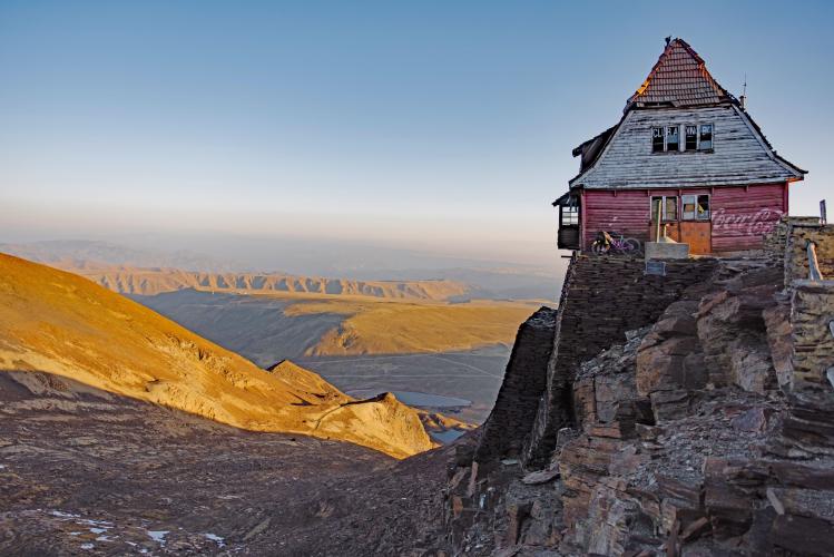
Above a sheer cliff, the forsaken refuge rests atop a foundation of flat rocks.
![]()
Tyler Pearce left and Jeremiah Bishop right.
HIKE TO SUMMIT OF CHACALTAYA
![]()
The final 5 kilometers can be hiked as an alternative to riding the bike to the top. We had no option in 2023 due to major storm dropping and excessive amount of snow on the mountain. The final 4 kilometers were impassible by car or bike so we hiked to the Refugio (8.8% average grade and 350 meters gained).
![]()
Top of bike climb - abandoned refugio and ski resort.
![]()
The hike to Chacaltaya Peak from the refugio is 700 meters at 11% average grade.
![]()
John and Javier at the refugio.