29.3
PDI
9.7 mi
DISTANCE
4,149 ft
GAINED
8 %
AVG. GRADE
FULL CLIMB STATS
INTRO
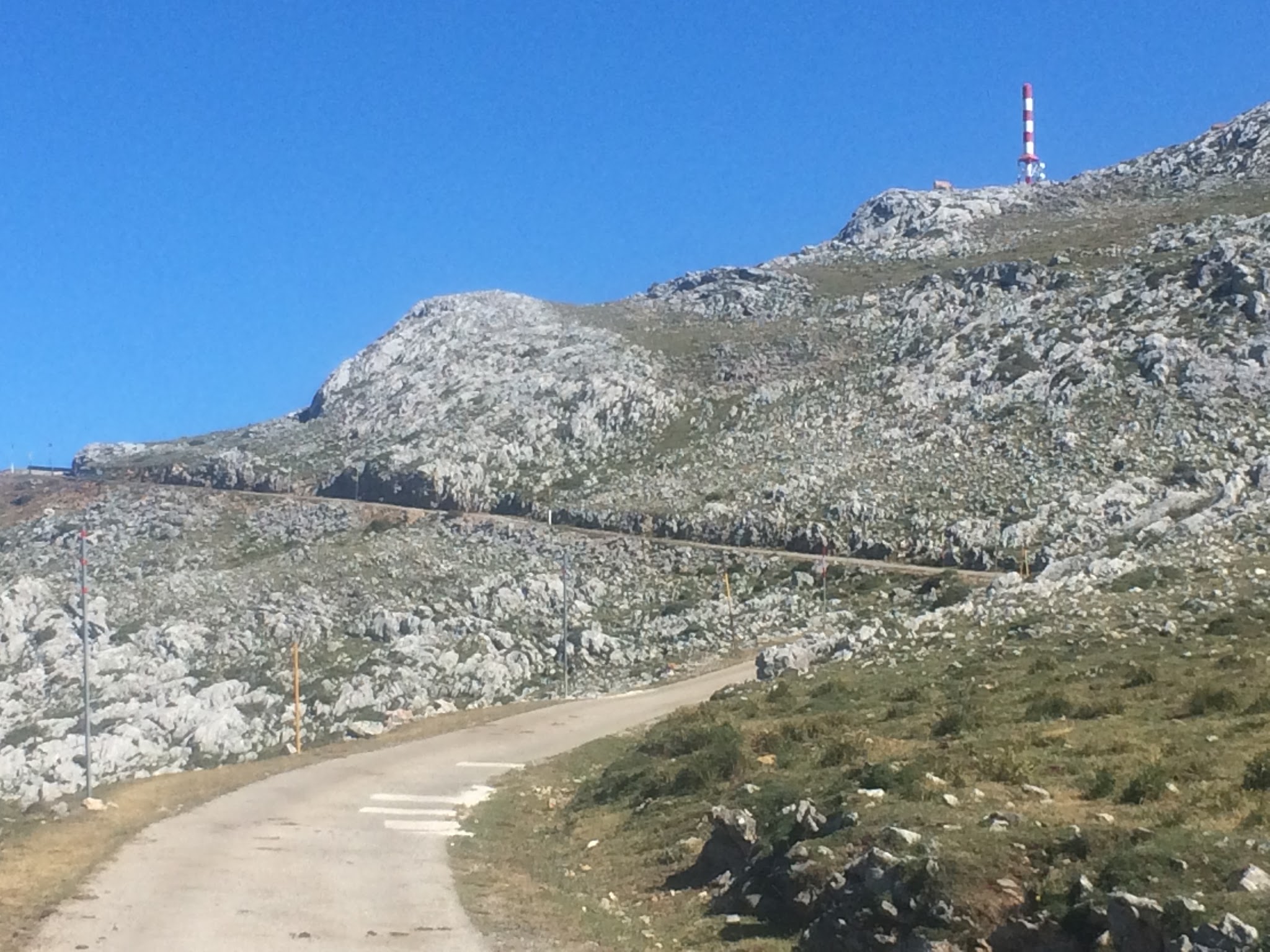
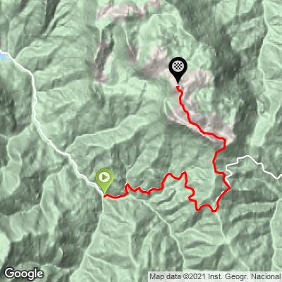
Alto de Gamoniteiro West is the quieter of the two ways up one of Asturias's hardest mountains, climbing 15.6 km (9.7 mi) and gaining 1,265 m (4,149 ft) at an 8.0% average grade from the small village of Santa Marina, in the Sierra del Aramo south of Oviedo. The road tops out near the radio-tower summit at 1,713 m (5,621 ft), currently ranked #355 in the world - a gentler line up the same peak the Vuelta made famous from the other side.
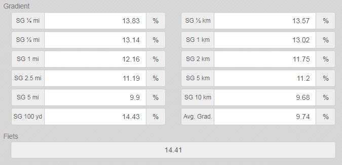
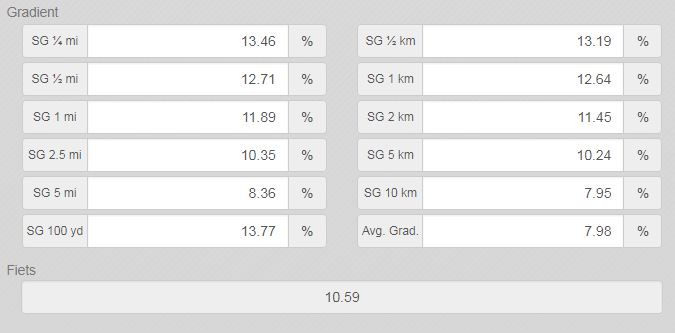
Where the eastern ascent from Pola de Lena gets the Vuelta history, this western side has its own reward: the road climbs past Alto de la Cobertoria, a separate high pass with a Neolithic-to-Bronze-Age megalithic necropolis at its summit and sweeping views across central Asturias, before turning off toward Gamoniteiro's own barren summit. Like its eastern twin, the final stretch is the hardest - the steepest kilometer, just below the top, averages 12.6%, with short ramps into the low teens before that.
This is a remote, lightly-traveled mountain road rather than a race-day spectacle - there's no equivalent to the Angliru's crowds here. Riders should still come prepared for a narrow, occasionally rough road and no services once you leave Santa Marina.
PLAN YOUR ROUTE
 We've partnered with Sherpa-Map.com to bring you the best route planning tool. With a PRO Membership you can use this climb as a reference when creating your route.
 Alto de Gamoniteiro West averages 8.0% over 15.6 km (9.7 mi), a touch gentler on paper than the eastern ascent, but the grade is far from steady. The steepest kilometer comes right near the top, averaging 12.6%, and the numbers ramp up fast as the road narrows toward the summit: the steepest 100 yards hits 13.7%, the steepest quarter mile 13.3%, and the steepest half mile 12.7%. Zoom out and the climb still bites - the steepest mile averages 11.8%, the steepest 2 km 11.3%, and the steepest 5 km 10.2%. The early miles out of Santa Marina are comparatively mild, which is what pulls the overall average down; nearly all of the real work is concentrated in the final third, climbing from around 477 m (1,564 ft) to 1,713 m (5,621 ft) with just 28 m (92 ft) of net descent along the way.
Roadway: The road is paved for its full length, but it's narrow throughout and the pavement quality drops noticeably in the final kilometers, with rougher, patched surface as you near the summit - similar to the character of the eastern approach. There are no reports of active closures or resurfacing work heading into the 2026 season. One navigation note: Google Maps' routing doesn't reliably send you left onto the correct turn toward Gamoniteiro around mile 5.7, so it's worth knowing the turn in advance rather than trusting the app in the moment.
Traffic: Very light. This is a remote rural road with local and agricultural traffic only outside of the rare organized cyclosportive - nothing like the crowds the Angliru sees on Vuelta stage days.
Parking: Santa Marina is a very small village with limited services, so parking is informal - a spot near the village center where the climb turns onto AS-230 works fine. Pola de Lena, about 15 minutes away by car, is the larger practical base for this side of the mountain if you need a hotel, a bike shop, or a bigger selection of parking.
There's nothing in the way of food, water, or bike services once you leave Santa Marina, so top off bottles before you start and carry what you need for a 15.6 km (9.7 mi) climb with no stores along the way. The final kilometers run rough and narrow with double-digit ramps, so a compact or wide-range gearing setup is worth having, and given the summit sits above 1,700 m (5,600 ft), pack a light layer even in summer - it's noticeably cooler and windier up top than down in the valley.
Before heading out on any cycling adventure check out our Things to Bring on a Cycling Trip and use our interactive check list to ensure you don't forget anything.
Santa Marina is a tiny village, so most riders base themselves in Pola de Lena, about 15 minutes away, which also anchors the climb up Gamoniteiro's eastern side and has a train station on the Asturias-Leon line. This corner of the Sierra del Aramo is genuinely one of Spain's great mountain-biking regions - the legendary Alto de l'Angliru and Gamoniteiro's eastern ascent are both a short drive away, making a multi-day trip based here worthwhile rather than a one-off detour.
Because the summit sits above 1,700 m (5,600 ft), conditions at the top can differ sharply from the valley floor even in warmer months - our Weather tool can help you check conditions at the finish before you commit to the climb.
ROUTE MAP
MEMBER RATING
CURRENT WEATHER
PJAMM TRIPS ADVENTURE STARTER BUNDLES
Check out PJAMM Adventure's prepackaged (self-guided) cycling trips. They will help you plan, document and conquer your next adventure.
NEARBY CLIMBS (0) RADIAL PROXIMITY
FROM No Climbs Found
MEMBER REVIEWS & COMMENTS
Let us know what you thought of this climb. Signup for our FREE membership to write a review or post a comment.
Already have an account?
LOG IN HERE