Hogpen Gap East Bike Climb - PJAMM Cycling

2.9
FIETS
7.2 mi
DISTANCE
2,161 ft
GAINED
5 %
AVG. GRADE

FULL CLIMB STATS

INTRO

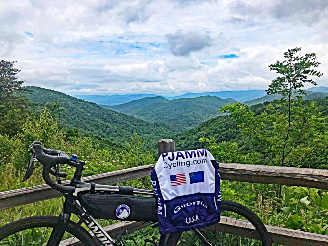
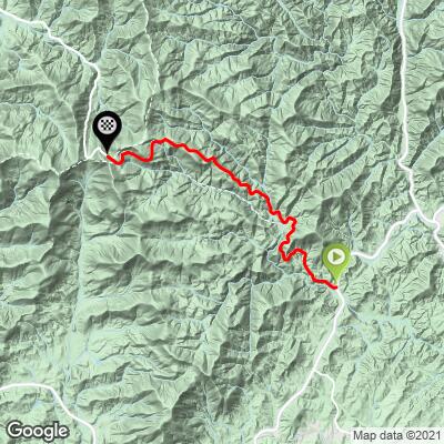
Cycling Hogpen Gap from the longer and easier side. This climb is included in the 6 Gap Century. We finish our climb at the Appalachian Trail. 
The average grade of 4.9% on this ride spikes to 7.2% when we eliminate descent from the gradient calculation.  There are three descents on the climb, the longest being one mile at -2.5%.  The gradient ranges for the climb are:  descent (1.5 miles / 20.3% of the climb); 0-5% (1.4 miles / 19.4%); 5-10% (3 miles / 42.1%); 10-15% (1.2 miles /  17.2%) and 15-20% (0.1 mile / 1.1%).  The steepest quarter-mile is 12.4% and there is a continuous mile averaging 10.2%.  

See more details and tools regarding this climb's grade via the “Profile Tool” button.

Roadway:  The roadway surface is in excellent condition although there is no shoulder.  However, we felt safe riding the climb the two times we have done it.

Traffic:  Mild to moderate.  Very light in the early morning. 

Parking:  You can park at the top and ride down to the start of the climb, or there is parking near the start - Map; Street View. 
Provisions:  In Helen four miles east - Map
Before heading out on any cycling adventure check out our Things to Bring on a Cycling Trip and use our interactive check list to ensure you don't forget anything.
We stayed in Helen on our two trips to the area. Helen is located just four miles miles northeast of the start of this bike climb - Map.  There are also many options for rental homes in the area.

Hogpen Gap is the most difficult climb of the 103.8 mile/11,230 vertical feet Six Gap Century (Neel Gap, Hogpen Gap, Unicoi Gap, Jack’s Gap, Wolfpen Gap, and Woody Gap). A route map of the Six Gap Century can be found here.  

A nice 45 mile loop with 6,305 vertical feet begins in Helen, and we have included Brasstown Bald (highest point in GA) in that route - ride 2.2 miles to 3,452’ gaining 1,235’ at 10.5% average grade. 

ROUTE MAP

MEMBER RATING

Difficulty: Strenuous
4.5
Road
3.5
Traffic
4.5
Scenery

CURRENT WEATHER

PJAMM TRIPS ADVENTURE STARTER BUNDLES

Check out PJAMM Adventure's prepackaged (self-guided) cycling trips. They will help you plan, document and conquer your next adventure.
ALL TRIPS
Browse all of our prepackaged trips and find your next adventure!
Smoky Mountain National Park
United States (NC,TN)
17 ROUTES
31 POIs
ROUTE STATS (TOTAL)
181.8
mi
DISTANCE
34,253
ft
ELEV. GAIN

NEARBY CLIMBS (0) RADIAL PROXIMITY

FROM
No Climbs Found

MEMBER REVIEWS & COMMENTS

Let us know what you thought of this climb. Signup for our FREE membership to write a review or post a comment.
Already have an account?

Oct 28, 2021
difficulty: Strenuous
scenery: 4
traffic: 3
road: 5
Oct 28, 2021
scenery: 4
traffic: 3
road: 5
Tougher climb than the average gradient will tell you. Awesome overlooks and vantage points at the top to make it all worth it. Also a bear ran into the road right in front of me halfway up.
Apr 12, 2021
difficulty: Strenuous
scenery: 5
traffic: 4
road: 4
Apr 12, 2021
scenery: 5
traffic: 4
road: 4
Hogpen is one of the most challenging climbs of the annual 6 Gaps ride. This is the customary approach, but that will be reversed in 2021. There are several overlooks that are worth checking out and photographing, depending on your sense of urgency in reaching the top/bottom. Fitness, nutrition and hydration plan is recommended in this area.
ROUTE MAP
PROFILE TOOL
Route Data
S.G. (%)
hide
Segment Data
hide

Climb Profile Not Found
CLIMB SUMMARY

Cycling Hogpen Gap East - road bike with PJAMM Cycling jersey laid out over seat, bike leaning against wooden railing, overlooking lush green ridge lines and mountainside with wildflowers

Cycling Hogpen Gap East

Ride 7.1 miles gaining 2,146’ at 4.9% average grade.

Climb summary by PJAMM’s John Johnson.

We are surrounded by the lush Appalachian Mountain forest as we climb.  The climb is much harder than its average 4.9% suggests because four descents (one of 1.1 miles at -2.1%) reduce the gradient for the overall 7.1 mile climb.  However, this is a tough bike ride with the first two miles at 5.9% and 10% average grade for 2.1 miles beginning at mile three.

Before heading out to climb Hogpen Gap, be sure to rely on our list of Things to Bring on a Cycling Trip, and use our interactive checklist to ensure you don't forget anything.

Cycling Hogpen Gap East - photo collage, US Forestry Service Appalachian Trail Hogpen Gap stone sign, Chattahoochee Wildlife Management sign with road bike with PJAMM cycling jersey draped over it leaning against sign, arial view of cyclist in PJAMM Cycling jersey  standing next to gradient road sign

This is one of the Six Gap Scenic North Georgia tour routes.

(Wolfpen Gap, Woody Gap, Neels Gap, Hogpen Gap, Unicoi Gap and Jacks Gap).

Climb begins by riding west up Route 348 (GA Scenic Byway) from its T intersection with Route 75A

Mile 4-5 averages 10%

The Hogpen Gap climbs are along Richard B. Russell Scenic Highway and end at the Appalachian Trail, which crosses our path at the Gap. These bike climbs are in the Blue Ridge Mountain subrange of the Appalachian Mountains and are in the Chattahoochee-Oconee National Forest (866,468 acres, established in 1936).

Hogpen East during fall colors.

Cycling Hogpen Gap East - photo collage, up close view of two-lane road with yellow divider lines, road bike leaning against wooden railing overlooking lush green hillsides, cyclist riding along road surrounded by lush greenery, road bike leaning against road sign noting Appalachian Trail Ahead, road bike with PJAMtM Cycling jersey draped over it leaning against Raven Cliffs Trailhead Chattahoochee National Forest sign

The 2,190 mile Appalachian Trail crosses Hogpen Gap at about 30 miles east of its start at

Springer Mountain, Georgia.

Cycling Hogpen Gap East - close up of Appalachian National Scenic trail map and information from US National Forest Service

View at the overlook at the top of the climb.

Hogpen Gap is the most difficult climb of the 103.8 mile/11,230 vertical feet  Six Gap Century (Neel Gap, Hogpen Gap, Unicoi Gap, Jack’s Gap, Wolfpen Gap, and Woody Gap).  A  route map of the Six Gap Century can be found here.

Hogpen Gap West

A nice 45 mile loop with 6,305 vertical feet begins in Helen, and we have included Brasstown Bald in that route.  Ride 2.2 miles to 3,452’ gaining 1,235’ at 10.5% average grade.

That’s a wrap!!

Access to full Climb Summary requires a PJAMM Cycling PRO Membership!

It takes less than a minute to sign up & with your PRO membership you can:
  • Rate climbs, post comments and share your experiences on any of our climb pages
  • Create bucket lists of climbs & mark the dates you complete them
  • Weather data for all climbs - Start & Finish
  • Upload photos to your member page to customize your PJAMM Cycling experience
  • Utilize all of our interactive tools - Profile & Routes in Area
  • Download climb route .gpx files
LEARN MORE
SIGN UP

Already have an account? LOG IN HERE