2.9
PDI
1.2 mi
DISTANCE
461 ft
GAINED
7.4 %
AVG. GRADE
FULL CLIMB STATS
INTRO
This 1.2 mile bike climb is located in Québec, Canada. The average gradient is 7.4% and there is a total elevation gain of 461 ft, finishing at 700 ft.
Use the profile tool, route map, and weather forecast to conquer this cycling climb.
Use the profile tool, route map, and weather forecast to conquer this cycling climb.
PLAN YOUR ROUTE
This climb averages 0%. The steepest quarter mile of this climb is 0%. NaN miles of the climb is at or above 10% grade. The gradient on this climb is broken down as follows:
See more details and tools regarding this climb's grade via our interactive Profile Tool.
See more details and tools regarding this climb's grade via our interactive Profile Tool.
Information Not Available
If you have any information regarding this climb, we'd like to hear from you. Click the CONTRIBUTE button to share your thoughts with us.
Information Not Available
If you have any information regarding this climb, we'd like to hear from you. Click the CONTRIBUTE button to share your thoughts with us.
Before heading out on any cycling adventure check out our Things to Bring on a Cycling Trip and use our interactive check list to ensure you don't forget anything.
Information Not Available
If you have any information regarding this climb, we'd like to hear from you. Click the CONTRIBUTE button to share your thoughts with us.
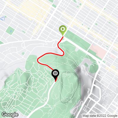
ROUTE MAP
MEMBER RATING
CURRENT WEATHER
PJAMM TRIPS ADVENTURE STARTER BUNDLES
Check out PJAMM Adventure's prepackaged (self-guided) cycling trips. They will help you plan, document and conquer your next adventure.
NEARBY CLIMBS (0) RADIAL PROXIMITY
FROM No Climbs Found
MEMBER REVIEWS & COMMENTS
Let us know what you thought of this climb. Signup for our FREE membership to write a review or post a comment.
Already have an account?
LOG IN HERE
vincr
This is a nice short climb in the heart of the city of Montreal. For Montrealers, it’s the must-do climb for anyone cycling in the city. At any time, you’ll find several cyclists climbing it. Professional cyclists climb it around 15 times each year in mid-September during the Grand prix cyclist de Montréal
The first 350 m are at 8% and then you have a 300 m of break at 4 %. Then the last part (900m) is at 8%-9%. At the top of the climb, you have one of the best spot in Montreal to see the sunset.
The road is usually closed for cars every Sunday morning during summer time. During the rest of the week, the shoulder is big enough (except for a small portion of a few metres at the end, which is narrow). Nevertheless, be careful with cars, there are a lot of tourists driving around and doing illegal U-turns.
The ride is part of a loop that takes you on a roughly 9-kilometre ride around Mount Royal with several other climbs. For the path, google Circuit Pro tour Mont Royal.