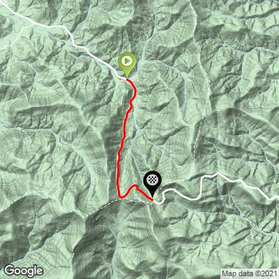
Hogpen Gap West Bike Climb - PJAMM Cycling

3.4
FIETS
2.4 mi
DISTANCE
1,181 ft
GAINED
9.4 %
AVG. GRADE

FULL CLIMB STATS

INTRO

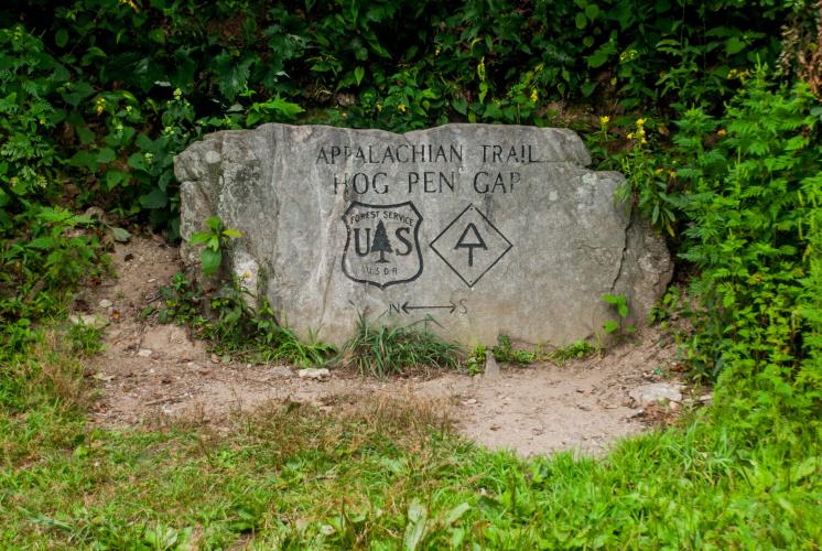
"One of the steepest roads in the U.S., the isolated west side of Hogpen Gap can test cold legs.  An isolated start is over moderate grade but that soon turns to double digit over most of the hill's length.  It is fairly steady however much of way which seems to blunt some of the sting.  Just past Tesnatee Gap (signed but unremarkable) you encounter the steepest half mile of the route.  From Tesnatee to just before the summit, the rock wall to your right is one of the few places in the Southeast one can ice climb in the winter.  The summit is obvious and cryptically signed (look up)..." (This quote is presented with the approval of John Summerson, from his book, The Complete Guide to Climbing (by Bike) in the Southeast, pg. 75.)
Average grade is 9.5%.  31% of the climb is at 5-10% and 62% is at 10-15%.  The steepest quarter-mile is 11.7%.

Use the “Routes in Area” button on the menu bar to see other bike climbs in this area. 
Roadway:  Two lane highway with no shoulder.

Traffic:  Light.

Parking:  At the top and then ride down and climb back up or on the side of the road at the start of the climb - Map Street View
Provisions:  The closest food and beverages from the start of this climb are in Helen, 13 miles south east (Map). 
Before heading out on any cycling adventure check out our Things to Bring on a Cycling Trip and use our interactive check list to ensure you don't forget anything.
We stayed in Helen on our trip.  There are many nice gap climbs in this area plus the highest climb in Georgia, Brasstown Bald.

ROUTE MAP

MEMBER RATING

Not Yet Rated
-
Road
-
Traffic
-
Scenery

CURRENT WEATHER

PJAMM TRIPS ADVENTURE STARTER BUNDLES

Check out PJAMM Adventure's prepackaged (self-guided) cycling trips. They will help you plan, document and conquer your next adventure.
ALL TRIPS
Browse all of our prepackaged trips and find your next adventure!
Smoky Mountain National Park
United States (NC,TN)
17 ROUTES
31 POIs
ROUTE STATS (TOTAL)
181.8
mi
DISTANCE
34,253
ft
ELEV. GAIN

NEARBY CLIMBS (0) RADIAL PROXIMITY

FROM
No Climbs Found

MEMBER REVIEWS & COMMENTS

Let us know what you thought of this climb. Signup for our FREE membership to write a review or post a comment.
Already have an account?
ROUTE MAP
PROFILE TOOL
Route Data
S.G. (%)
hide
Segment Data
hide

Climb Profile Not Found
CLIMB SUMMARY

Cycling Hogpen Gap West - road bike with PJAMM Cycling jersey laid out over seat, bike leaning against wooden railing, overlooking lush green ridge lines and mountainside with wildflowers

Cycling Hogpen Gap West

Ride 2.4 miles gaining 1,203’ at 9.5% average grade.

Before heading out to cycle Hogpen Gap, be sure to rely on our list of Things to Bring on a Cycling Trip, and use our interactive checklist to ensure you don't forget anything.

Climb summary by PJAMM’s John Johnson.

We are surrounded by the lush Blue Ridge Mountain forest during this challenging and fun bike climb.

Cycling Hogpen Gap West - photo collage, Garmin device showing 18% grade, cyclist riding on road surrounded by lush and dense green foliage, bike leaning against wooden rail overlooking green ridge line with wild flowers in foreground, bike laying in the middle of a two lane road, with PJAMM cycling jersey draped over seat, Appalachian Trail Hogpen Gap US Forestry service sign

PJAMM Adventure App - beginning of Hogpen West climb

The steepest ½ mile on this climb is 11.5% and begins at mile .5

The Hogpen Gap climbs are along Richard B. Russell Scenic Highway and end at the Appalachian Trail, which crosses our path at the Gap. This bike climb is in the Blue Ridge Mountain subrange of the Appalachian Mountains and is in the Chattahoochee-Oconee National Forest (866,468 acres established in 1936).

Cycling Hogpen Gap West - photo collage, dense green foliage and greenery surrounding two lane roadways, bike parked in tall grass along side of road next to yellow wildflowers, yellow road sign advertising using caution for large trucks

The 2,190 mile Appalachian Trail crosses at Hogpen Gap about 30 miles east of its start at Springer Mountain, Georgia.

We also pass Tesnatee Gap at the big left turn 0.6 miles from the top (see upper left center photo).

Top of the climb.

Cycling Hogpen Gap West - close up of Appalachian National Scenic trail map and information from US National Forest Service

Hogpen Gap West during early fall colors.

Access to full Climb Summary requires a PJAMM Cycling PRO Membership!

It takes less than a minute to sign up & with your PRO membership you can:
  • Rate climbs, post comments and share your experiences on any of our climb pages
  • Create bucket lists of climbs & mark the dates you complete them
  • Weather data for all climbs - Start & Finish
  • Upload photos to your member page to customize your PJAMM Cycling experience
  • Utilize all of our interactive tools - Profile & Routes in Area
  • Download climb route .gpx files
LEARN MORE
SIGN UP

Already have an account? LOG IN HERE