
24.8
PDI
17.9 mi
DISTANCE
4,834 ft
GAINED
4.8 %
AVG. GRADE
FULL CLIMB STATS
INTRO
PLAN YOUR ROUTE
 We've partnered with Sherpa-Map.com to bring you the best route planning tool. With a PRO Membership you can use this climb as a reference when creating your route.
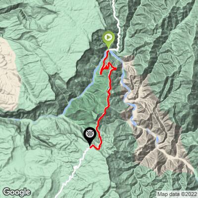
Average grade is 4.8% over 28.8 km (17.9 mi), rising from 554 m (1,819 ft) at the Pescadero bridge to 1943 m (6,374 ft). The first 10 km (6.2 mi) climb about 590 m (1,930 ft), an average of 5.9%, and the road eases between roughly 20 km and 25 km (12.4 and 15.5 mi), gaining only about 70 m (230 ft) before a final pull to the top.
The steepest 100 yards (91 m) reach 12.3%, the steepest quarter mile (0.4 km) averages 10.4%, the steepest mile (1.6 km) 8.3%, and the steepest 5 km (3.1 mi) 6.7%.
Roadway: Paved the whole way and generally good, on the main Bucaramanga - San Gil - Bogota highway. At the bottom, the Pescadero sector (km 53) has been under repair since the Chicamocha River undermined the road bank in July 2026: traffic runs on a single lane under traffic control, and in mid-September 2026 Invías reported protective riprap work about 75% complete, with the permanent solution still being studied. Expect to be held briefly at the start of the climb.
Traffic: Heavy. This is the main road between Santander and Bogota, with lots of trucks. Since July 12, 2026 heavy cargo vehicles have been banned from the Pescadero sector and rerouted, so truck traffic has been lighter than usual, but the authorities were aiming to restore heavy traffic before September 30, 2026, so assume the trucks are back until you see otherwise.
Parking: Pescadero, at the bridge, has a service station and a few roadside businesses; park off the roadway and stay clear of the repair zone. Many riders instead start in Bucaramanga, descending the canyon road to the bridge first and then climbing back out.
Provisions: There are cafes, restaurants and other provisions at the Parque Nacional del Chicamocha at km 12.6 (7.8 mi), where you can stop at the cafe and visitor center or take the cable car across the canyon, and in the town of Aratoca at the top of the climb. The lower canyon is hot and dry, so start with full bottles.
Weather: You climb from 554 m to 1943 m (1,819 ft to 6,374 ft), so it will be noticeably cooler at the top, and afternoon showers are common in the Andes; carry a light rain layer.
Before heading out on any cycling adventure check out our Things to Bring on a Cycling Trip and use our interactive check list to ensure you don't forget anything.
The Chicamocha is one of the largest canyons in the world, nearly 2000 m (6,562 ft) deep and more than 200 km (124 mi) long. The climb passes through the Parque Nacional del Chicamocha (Panachi), where a 6.3 km (3.9 mi) cable car with 39 cabins crosses the canyon in about 25 minutes. The park's Kaktus restaurant is a popular stop for the panoramic views.
Bucaramanga is the practical base for the ride. To see other Santander climbs nearby, try our Routes in the Area tool.
ROUTE MAP
MEMBER RATING
CURRENT WEATHER
PJAMM TRIPS ADVENTURE STARTER BUNDLES
Check out PJAMM Adventure's prepackaged (self-guided) cycling trips. They will help you plan, document and conquer your next adventure.
NEARBY CLIMBS (0) RADIAL PROXIMITY
FROM No Climbs Found
MEMBER REVIEWS & COMMENTS
Let us know what you thought of this climb. Signup for our FREE membership to write a review or post a comment.
Already have an account?
LOG IN HERE
