
12.5
PDI
6.8 mi
DISTANCE
2,185 ft
GAINED
6.1 %
AVG. GRADE
FULL CLIMB STATS
Page Contributor(s): Leo Lagos, Chile
INTRO
PLAN YOUR ROUTE
 We've partnered with Sherpa-Map.com to bring you the best route planning tool. With a PRO Membership you can use this climb as a reference when creating your route.
 The climb is remarkably consistent for an Andean pass. After a flat two-kilometer approach from Lo Pinto, the grade settles into a steady 6-7% for essentially the entire remaining ascent - the steepest kilometer still averages under 7%, with no isolated double-digit ramps to catch riders out.
That evenness, combined with the recently improved road surface, makes Cuesta Chacabuco a good climb for pacing rather than punching through steep pitches - settle into a rhythm near the base and you can hold it essentially unchanged all the way to the cross at the summit.
Roadway: The pavement is in excellent condition. Chile's Ministry of Public Works recently repaved the full climb, widened several of the tighter curves, and rebuilt the stormwater drainage system, and the road is kept as the official backup route whenever the modern Chacabuco tunnel on Ruta 5 needs to close. Being an Andean pass, it can still shut temporarily for heavy winter storms - a July 2026 closure followed a system that dropped meters of snow in the nearby cordillera - so check Vialidad's status before a winter trip.
Traffic: Traffic is light on a normal day, since most Santiago-to-Aconcagua Valley traffic now uses the tunnel below. Expect more traffic, including trucks, on the rare days the tunnel is closed and this becomes the official detour.
Parking: Riders typically stage in or near Lo Pinto, in the Colina commune, at the base of the climb; those combining it with a descent on the north side can also start from near the Casino Enjoy area on the Los Andes side.
There are no services on the climb itself, so fuel up in Lo Pinto or Colina beforehand. The steady 6-7% grade is well suited to standard road gearing - this isn't a climb that demands an especially low gear.
Partway up, the sheer Chacabuco rock formations are a well-known local rock-climbing area, worth a look even from the saddle. The summit sits exposed to wind, so a light packable layer is worth carrying even on a warm day lower down.
Before heading out on any cycling adventure check out our Things to Bring on a Cycling Trip and use our interactive check list to ensure you don't forget anything.
Cuesta Chacabuco makes an easy half-day out of Santiago - Lo Pinto is roughly 45 minutes to an hour north of the city by car. Mornings are best, since the lower slopes get hot and exposed by midday.
Riders looking to extend the day can descend the north side toward the Casino Enjoy area near Los Andes, with views of Aconcagua on a clear day, before returning the way they came. Our Routes in the Area tool can help find other climbs nearby to combine with this one.
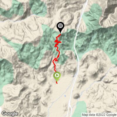
ROUTE MAP
MEMBER RATING
CURRENT WEATHER
PJAMM TRIPS ADVENTURE STARTER BUNDLES
Check out PJAMM Adventure's prepackaged (self-guided) cycling trips. They will help you plan, document and conquer your next adventure.
NEARBY CLIMBS (0) RADIAL PROXIMITY
FROM No Climbs Found
MEMBER REVIEWS & COMMENTS
Let us know what you thought of this climb. Signup for our FREE membership to write a review or post a comment.
Already have an account?
LOG IN HERE
