
11.1
PDI
5 mi
DISTANCE
1,814 ft
GAINED
6.9 %
AVG. GRADE
FULL CLIMB STATS
Page Contributor(s): Leo Lagos, Chile
INTRO
PLAN YOUR ROUTE
 We've partnered with Sherpa-Map.com to bring you the best route planning tool. With a PRO Membership you can use this climb as a reference when creating your route.
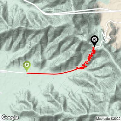
 The climb runs at a fairly steady 6-7% for most of its 8.1 km - our data shows the grade holding firm rather than easing, with a short, sharper pitch near 12% in the closing switchbacks just below the summit ridge.
It's a workmanlike grade throughout - no long flat respites, but nothing in the double digits until that last punch near the top.
Roadway: The pavement is in excellent condition and well maintained, helped by a ban on truck traffic that keeps heavy vehicles off the old road. The final approach through the zigzag switchbacks below the summit is where the surface and sightlines matter most - take the blind corners wide.
Traffic: Traffic is light to very light. With Ruta 68's Lo Prado tunnel carrying the modern through-traffic below, riders here mostly share the road with other cyclists, motorcyclists, and the occasional local car.
Parking: Riders typically stage near Curacaví at the base of the climb, with additional pull-off parking available partway up as the road nears the switchback section.
There are no services directly on the climb, so fuel up in Curacaví before you start. Standard road gearing covers most of the ascent, though a slightly easier gear is worth having in reserve for the steeper switchbacks just below the summit.
Descending is fast and clean, with no hazardous blind corners reported - check your brakes before heading back down.
Before heading out on any cycling adventure check out our Things to Bring on a Cycling Trip and use our interactive check list to ensure you don't forget anything.
Curacaví is about 45 minutes west of Santiago, making Cuesta Lo Prado an easy half-day out of the capital. Morning starts are best, before the valley heats up.
Cuesta Barriga, the historic 1937 pass a short drive south near María Pinto, makes a natural pairing for a longer day in the same hills - our Routes in the Area tool can help plan a route linking the two.
ROUTE MAP
MEMBER RATING
CURRENT WEATHER
PJAMM TRIPS ADVENTURE STARTER BUNDLES
Check out PJAMM Adventure's prepackaged (self-guided) cycling trips. They will help you plan, document and conquer your next adventure.
NEARBY CLIMBS (0) RADIAL PROXIMITY
FROM No Climbs Found
MEMBER REVIEWS & COMMENTS
Let us know what you thought of this climb. Signup for our FREE membership to write a review or post a comment.
Already have an account?
LOG IN HERE
