
27.2
PDI
15.8 mi
DISTANCE
4,925 ft
GAINED
5.7 %
AVG. GRADE
FULL CLIMB STATS
INTRO
Roque de Agando climbs 25.4 km (15.8 mi) from the ferry port of San Sebastián de La Gomera up into the volcanic interior of La Gomera, in Spain's Canary Islands, gaining 1,501 m (4,925 ft) at a 5.7% average grade to a high point of roughly 1,465 m (4,806 ft) near Garajonay National Park.
The climb takes its name from the rock it passes directly beneath: Roque de Agando, a 1,251 m volcanic plug - the eroded throat of an ancient volcano - and one of La Gomera's most photographed landmarks. It's the tallest of the three towers making up the Los Roques natural monument.
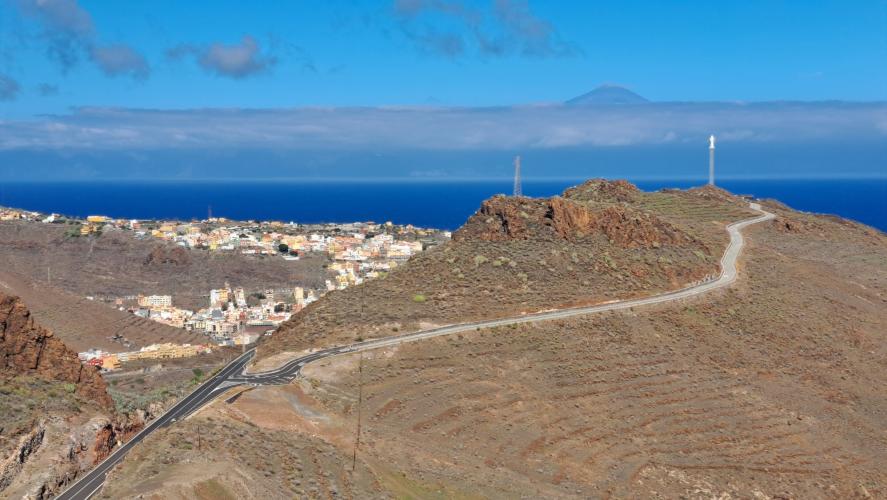
The GM-2 winds through pine forest and then laurisilva as it gains the island's central ridge, entering Garajonay National Park, a UNESCO World Heritage cloud forest, for its final kilometers.
Grades are uneven rather than a steady grind - a long, moderate middle section gives way to a steepest kilometer averaging 12.8% as the road switchbacks toward the ridge. Traffic is light once you're past San Sebastián's outskirts, though the GM-2 remains the main road linking the capital to the island's southern towns and airport.
The Cabildo de La Gomera began repaving sections of this road in early 2026 as part of a wider improvement project. Riders extending the day can see other nearby climbs, including two routes up to Garajonay from the island's north side, with our Routes in the Area tool.
PLAN YOUR ROUTE
 We've partnered with Sherpa-Map.com to bring you the best route planning tool. With a PRO Membership you can use this climb as a reference when creating your route.
 Roque de Agando climbs 25.4 km (15.8 mi) and gains 1,501 m (4,925 ft), averaging 5.7% from the port at 17 m (57 ft) up to about 1,465 m (4,806 ft) near Garajonay National Park.
The grade is uneven rather than a steady grind. After a rolling start out of San Sebastián, the road settles into a long, moderate mid-section before steepening noticeably in its closing kilometers as it switchbacks up toward the island's central ridge. The steepest kilometer averages 12.8%, and the steepest mile averages 11.2% - both well above the overall average, so save something for the final third of the climb.
Roadway: The GM-2 (Carretera del Centro) is paved the entire way from San Sebastián de La Gomera to Garajonay National Park. The Cabildo de La Gomera began an asphalt-resurfacing project on more than 7 km of this road between San Sebastián and the Degollada de Peraza in February 2026, part of a larger improvement plan for the route - check the Cabildo's road-status announcements before you go in case of short, localized closures while that work continues.
Traffic: Moderate near San Sebastián, where the GM-2 is the main link between the capital, the airport, and the island's southern towns. Traffic thins out considerably once the road climbs into the forest and gains real elevation, and the final kilometers through Garajonay National Park are quiet outside of peak midday tourist traffic.
Parking: San Sebastián de La Gomera is the island's ferry port and capital, with ample on-street parking near the harbor and town center where the GM-2 begins its climb south. Gomera Cycling, a local bike shop and rental outfit based in town, is a useful landmark for finding the start.
San Sebastián de La Gomera has full services - grocery stores, bakeries, and cafes - for a final food and water stop before heading out. Options thin out quickly after that: there's little along the GM-2 itself until the Venta de la Degollada de Peraza, a small bar/restaurant near the top of the climb that serves basic food and drink to hikers and drivers passing through Garajonay National Park. Carry enough water for the full climb rather than counting on that stop being open.
Before heading out on any cycling adventure check out our Things to Bring on a Cycling Trip and use our interactive check list to ensure you don't forget anything.
San Sebastián de La Gomera is most visitors' first stop on the island - the Fred. Olsen fast ferry from Los Cristianos on Tenerife takes about 50 minutes and lands right in town, making this climb an easy start- or end-of-trip ride without arranging a car shuttle. The old quarter near the harbor, with its 15th-century Iglesia de la Asunción - where, according to local tradition, Columbus prayed before his 1492 voyage - is worth a walk before or after riding.
The climb's namesake, Roque de Agando, is best appreciated from the Mirador de los Roques pullout on the GM-2, where all three volcanic towers of the Los Roques natural monument - Agando, Ojila, and Zarcita - come into view together; it's a natural photo stop partway up. Garajonay National Park's laurisilva cloud forest at the top of this climb is the same UNESCO World Heritage forest reached from the island's north side via Hermigua, so if you're based in San Sebastián for a few days, this is the more direct way into it.
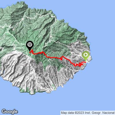
ROUTE MAP
MEMBER RATING
CURRENT WEATHER
PJAMM TRIPS ADVENTURE STARTER BUNDLES
Check out PJAMM Adventure's prepackaged (self-guided) cycling trips. They will help you plan, document and conquer your next adventure.
NEARBY CLIMBS (0) RADIAL PROXIMITY
FROM No Climbs Found
MEMBER REVIEWS & COMMENTS
Let us know what you thought of this climb. Signup for our FREE membership to write a review or post a comment.
Already have an account?
LOG IN HERE
