
16.9
PDI
6.6 mi
DISTANCE
2,588 ft
GAINED
7.5 %
AVG. GRADE
FULL CLIMB STATS
INTRO
PLAN YOUR ROUTE
 We've partnered with Sherpa-Map.com to bring you the best route planning tool. With a PRO Membership you can use this climb as a reference when creating your route.
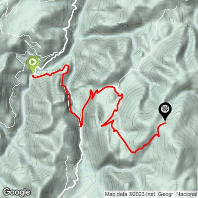
Collau Fancuaya gains 789 m (2588 ft) in 10.5 km (6.5 mi), a 7.5% average, from 278 m (914 ft) to 1064 m (3490 ft).
The first 3.5 km (2.2 mi) to Villabre hold a steady 6%. Things change after that: 1.5 km (0.9 mi) at about 10% into Yernes, including the steepest 0.5 km (0.3 mi) of the climb at 14.6%. Above Yernes the grade comes in waves - a short easing near km 5.5, a sharp 11% stretch around km 6, then 8-10% for most of the way from km 7.5 to km 9.5 before the last kilometer relaxes to about 6%.
The steepest kilometer averages 12.4%, the steepest 2 km (1.2 mi) 9.8%, the steepest 5 km (3.1 mi) 8.5% and the steepest 10 km (6.2 mi) 7.6%. The Vuelta's 2022 road book listed ramps up to 19%, so expect short pitches on the upper road well above these averages.
Roadway: Asphalt all the way to the col. The lower road from La Veiga to Villabre is an ordinary two-way local road; above Yernes it becomes a single-lane farm road, only paved in 2019, with guardrails on the steep side. Expect grit washed into the corners and the odd cowpat where herds cross between pastures. Beyond the col the pavement ends and a rough track continues - not one for road tires.
Traffic: Light. The valley road carries local cars to and from Tameza, and above Yernes you'll mostly meet farm vehicles. On the single-lane section a 4x4 coming down means one of you pulls over.
Parking: There's no car park at the start, which is just a bend in the Grado-Tameza road at La Veiga (start on Google Maps). Most riders either ride out from Grado or park considerately in Villabre, 3 km up the climb, and roll back down to begin. Keep farm gates and passing places clear.
Gear: Gear for the half kilometer into Yernes and the 10% steps higher up rather than for the average: a 34-tooth chainring with a 30- to 32-tooth cog is about right. The upper road is narrow and steep on the way down, so good brakes matter more than anything aero.
Provisions: Fill your bottles before you leave Grado. Yernes y Tameza has almost no services - the town hall and a small medical clinic in Villabre are about it - and there's nothing at the col. Pack a rain shell: the upper slopes catch Atlantic cloud even in summer.
Before heading out on any cycling adventure check out our Things to Bring on a Cycling Trip and use our interactive check list to ensure you don't forget anything.
Grado is the practical base. It sits on the A-63 west of Oviedo, so it's easy to reach, and it has the shops, cafes and beds that Yernes y Tameza doesn't.
If you're on a gravel bike, the col doesn't have to be a turnaround. The regional tourism board's Cuevallagar y Banduxu loop from Trubia goes over Fancuaya, follows about 2 km of rough track to Cuevallagar at 1087 m, then drops to Banduxu, a tiny hamlet of well-kept medieval houses in Proaza, before heading home on the Senda del Oso greenway. After rain the track turns to mud and you may end up carrying the bike.
On a rest day, the Puertos de Marabio natural monument and Pico Caldoveiro (1357 m) are limestone karst country, full of sinkholes and caves, and good walking. For more Vuelta roads, Puerto San Lorenzo and the Teverga valley are just to the south, and our Puerto de la Cruz de Linares page covers the race's 2023 summit finish on the Trubia side, one valley east.
ROUTE MAP
MEMBER RATING
CURRENT WEATHER
PJAMM TRIPS ADVENTURE STARTER BUNDLES
Check out PJAMM Adventure's prepackaged (self-guided) cycling trips. They will help you plan, document and conquer your next adventure.
NEARBY CLIMBS (0) RADIAL PROXIMITY
FROM No Climbs Found
MEMBER REVIEWS & COMMENTS
Let us know what you thought of this climb. Signup for our FREE membership to write a review or post a comment.
Already have an account?
LOG IN HERE
