
16.7
PDI
8.7 mi
DISTANCE
2,863 ft
GAINED
6.2 %
AVG. GRADE
FULL CLIMB STATS
INTRO
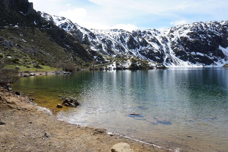
Most Somiedo climbs end at a pass. This one ends at the water's edge of Lago del Valle, the largest glacial lake in Asturias, sitting under a cirque of peaks at the head of the valley above Valle de Lago.
From Pola de Somiedo it's 14.0 km (8.7 mi) with 873 m (2863 ft) of climbing at 6.2%, from 699 m (2292 ft) to 1557 m (5109 ft). The hard part comes first: six kilometers of hairpins out of Pola, mostly 7.5 to 11%, with the steepest kilometer at 14.1% just past the halfway mark. Then the valley opens out and the road rolls easily for three kilometers into Valle de Lago, a village of stone houses where the asphalt ends.
The last 4.5 km are a different ride. Past the gate at the top of the village, the farm track to the lake is closed to cars, and much of the upper part is concrete. It runs gently up the valley for 1.5 km, past teitos - the thatched stone huts Somiedo's herders used in the summer pastures - and then climbs at 6 to 11% for the final 3 km to the lake's retaining wall. Bring wide tires, ride it slowly, and expect to share it with walkers and grazing cattle all summer.
PLAN YOUR ROUTE
 We've partnered with Sherpa-Map.com to bring you the best route planning tool. With a PRO Membership you can use this climb as a reference when creating your route.
14.0 km (8.7 mi) at 6.2%, gaining 873 m (2863 ft) from 699 m (2292 ft) in Pola de Somiedo to 1557 m (5109 ft) at the lake.
Kilometers 1 to 6 out of Pola run 6.4%, 8.4%, 10.3%, 8.1%, 11.0% and 7.5%. The steepest kilometer, at 14.1%, straddles kilometers 5 and 6 and includes a half kilometer at 16.1%; the steepest 5 km average 9.3%.
From km 6 to the top of Valle de Lago village, at about km 9.5, the road barely climbs: a short dip, then 1.5 to 3.5%. The track to the lake keeps that easy rhythm for another 1.5 km, then finishes with kilometers of 6.2%, 8.0% and 10.8% up to the lake.
Roadway: Asphalt for the first 9.5 km, from Pola de Somiedo up the hairpins to the top of Valle de Lago village. From the gate at the end of the village the final 4.5 km follow the farm track to the lake, closed to motor traffic apart from farm vehicles. Long stretches of the upper track are concrete, steep near the top and liable to be slippery when wet. It's a track rather than a road, so a gravel bike or wide tires (32 mm or more) make it far more comfortable; on narrow road tires, consider locking up in the village and walking the last part.
Traffic: Light. The road serves Valle de Lago and walkers heading for the lake, so summer weekends bring cars up to the village car park. On the track you'll meet hikers, cattle and the odd farm vehicle. Herds here are guarded by mastiffs - give them space and don't stop to make friends.
Parking: There's parking in Pola de Somiedo near where the climb starts. At the top of Valle de Lago village a car park by the fountain marks the end of the road for cars and the start of the walk to the lake.
Gear: Gear for the hairpins rather than the average: kilometers 2 to 6 average over 9%, and the track's last kilometer is near 11% on concrete. Something like 34x34 is sensible, and a gravel bike is the right tool for the whole climb.
Provisions: Stock up in Pola de Somiedo. Valle de Lago has a restaurant, and the fountain by the car park at the top of the village is the last water - there's nothing at the lake. At 1557 m (5109 ft) the lakeshore can be cold and windy even in summer, and the slopes around it can hold snow into spring.
Before heading out on any cycling adventure check out our Things to Bring on a Cycling Trip and use our interactive check list to ensure you don't forget anything.
Pola de Somiedo is the base for the whole natural park - our Puerto San Lorenzo and Alto La Farrapona pages cover the bear interpretation center, the ethnology museum and the Saliencia lakes walk. This climb adds Valle de Lago and the lake above it.
Leave time to walk at the top. The PR-AS 15.1 trail follows the lake's retaining wall to the far shore, with a short detour to the Cobrana teito, and comes back down the valley past the Gabitón braña, a group of thatched huts in good condition, and the church of Santa María Magdalena. The full circuit is 14.6 km from the village, so most riders will just walk the lakeside part in cleats or bring light shoes.
Pola is the start of several Somiedo climbs, and if you want to link two in a day, Routes in the Area maps them side by side.
ROUTE MAP

MEMBER RATING
CURRENT WEATHER
PJAMM TRIPS ADVENTURE STARTER BUNDLES
Check out PJAMM Adventure's prepackaged (self-guided) cycling trips. They will help you plan, document and conquer your next adventure.
NEARBY CLIMBS (0) RADIAL PROXIMITY
FROM No Climbs Found
MEMBER REVIEWS & COMMENTS
Let us know what you thought of this climb. Signup for our FREE membership to write a review or post a comment.
Already have an account?
LOG IN HERE
