
19.5
PDI
11.5 mi
DISTANCE
3,520 ft
GAINED
5.6 %
AVG. GRADE
FULL CLIMB STATS
INTRO
PLAN YOUR ROUTE
 We've partnered with Sherpa-Map.com to bring you the best route planning tool. With a PRO Membership you can use this climb as a reference when creating your route.
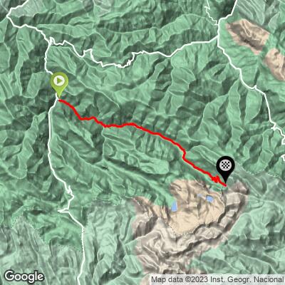
Over 18.5 km (11.5 mi) the road gains 1,073 m (3,520 ft) at 5.6% on average. The steepest 100 yards reach 11.3%, the steepest half kilometer (0.3 mi) averages 10.4%, the steepest kilometer (0.6 mi) 9.9%, the steepest 2 km (1.2 mi) 9.6% and the steepest 5 km (3.1 mi) 9.3%.
The steepest 10 km (6.2 mi) average 6.8%, so the remaining 8.5 km (5.3 mi) are far gentler. That is the valley approach, which flatters the average; the real work is concentrated in the upper half of the climb, where the steepest 5 km (3.1 mi) hold 9.3%.
Roadway: Paved from Pola de Somiedo up the Valle de Saliencia to the car park at the Alto de la Farrapona, where the asphalt ends. The León side of the pass is an unmaintained track that guides do not recommend for road bikes or ordinary cars, and navigation apps can route you onto it, so turn around at the pass.
Traffic: The road serves the valley villages and the hikers' car park at the top, which fills quickly on busy days, so expect more cars on summer weekends and holidays and on days when the lakes walk is popular.
Parking: Castro and Pola de Somiedo are small, so park considerately at the village edge rather than in the narrow streets. The car park at the top of the climb is for visitors to the lakes and fills early in peak season, which is one more reason to arrive by bike.
Provisions: Stock up in Pola de Somiedo before you ride and carry what you need to the top. The top is above 1,600 m (5,249 ft) and weather there can change quickly even in summer, so pack a warm layer and a windproof for the descent.
Gear: A compact crankset and a wide cassette handle the 5.6% average, but the steepest 5 km (3.1 mi) hold 9.3%. If you plan the lakes walk at the top, bring walking shoes or lightweight trail shoes you can carry or leave with the bike.
Before heading out on any cycling adventure check out our Things to Bring on a Cycling Trip and use our interactive check list to ensure you don't forget anything.
Everything here sits inside the Somiedo Natural Park, a Biosphere Reserve and Natura 2000 site. The car park at the top is the start of a circular 7.6 km (4.7 mi) walk of about 318 m (1,043 ft) of cumulative ascent past four lakes in the Lagos de Saliencia group: Lago de la Cueva (about 15 minutes from the car park), Lago Almagrera, Lago Cerveriz and Lago Calabazosa, also called Lago Negro, which is the largest and deepest at about 60 m (197 ft). Allow three to five hours, keep dogs on a leash, give livestock plenty of room, and do not approach or feed the guard mastiffs.
Spring, summer and autumn are the usual seasons for the top of the pass. Pola de Somiedo is the main base for the park and has a tourist office. At this elevation conditions can change quickly, so check conditions at the finish before you set off with our Weather tool.
ROUTE MAP
MEMBER RATING
CURRENT WEATHER
PJAMM TRIPS ADVENTURE STARTER BUNDLES
Check out PJAMM Adventure's prepackaged (self-guided) cycling trips. They will help you plan, document and conquer your next adventure.
NEARBY CLIMBS (0) RADIAL PROXIMITY
FROM No Climbs Found
MEMBER REVIEWS & COMMENTS
Let us know what you thought of this climb. Signup for our FREE membership to write a review or post a comment.
Already have an account?
LOG IN HERE
