
18.7
PDI
5.9 mi
DISTANCE
2,592 ft
GAINED
8.4 %
AVG. GRADE
FULL CLIMB STATS
INTRO
PLAN YOUR ROUTE
 We've partnered with Sherpa-Map.com to bring you the best route planning tool. With a PRO Membership you can use this climb as a reference when creating your route.
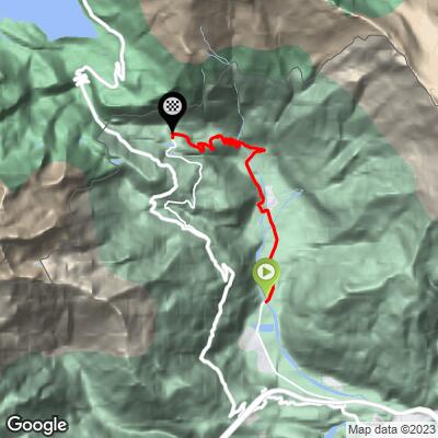
Moncenisio climbs 9.4 km (5.8 mi) and gains 790 m (2,592 ft) at an average of 8.4%.
The climb has two distinct parts. From Venaus to Novalesa, the first 4 km (2.5 mi) climb at a steady 6-7%. Above Novalesa, the hairpin section to Moncenisio covers about 5.4 km (3.4 mi) at close to 10%, with several kilometers between 10% and 11%.
The steepest kilometer averages 11.8%, the steepest 2 km (1.2 mi) 10.9% and the steepest 5 km (3.1 mi) 10.1%. The steepest 500 m (0.3 mi) averages 12.6%, and the steepest 100 m pitch reaches 17.4%.
Roadway: Paved the entire way. The SP210 from Venaus to Novalesa is a normal two-lane valley road; above Novalesa, the SP212 to Moncenisio is a narrow single-lane road of about 3 m with tight hairpins and a 3.5-tonne weight limit. Riders describe the surface as very good. The old road between Novalesa and Moncenisio is closed to cars in winter, so plan this climb for late spring to autumn.
Traffic: Light. Through Venaus and Novalesa you'll meet local traffic, but the upper hairpins see very few cars - riders report long stretches with almost no vehicles - and the weight limit keeps trucks and coaches off entirely. Take care on blind hairpins on the descent, since the road is too narrow for two cars to pass easily.
Parking: Park in Venaus at the bottom, or in Novalesa if you want to ride only the steep hairpin section - the lot by the Rio Bard bridge, on the road to Novalesa Abbey, is used by hikers heading for the abbey waterfalls. At the top, there's parking in Moncenisio village, the usual starting point for walks on the old Mont Cenis road.
Provisions: Fill up in Venaus or Novalesa. Moncenisio is a tiny village of a few dozen residents, so don't count on finding food or drink at the top.
Gear: More than 5 km at close to 10% calls for a compact crank and a 32- or 34-tooth low cog. Carry a layer for the descent - Moncenisio sits at over 1400 m (4,593 ft) and the narrow hairpins keep descending speeds low, so it can be a chilly ride down.
Before heading out on any cycling adventure check out our Things to Bring on a Cycling Trip and use our interactive check list to ensure you don't forget anything.
Novalesa, at the foot of the hairpins, is the cultural heart of the Val Cenischia. Novalesa Abbey was founded in 726 on the historic route over the Mont Cenis and has been run by Benedictine monks since 1973; four medieval chapels from the 8th to 11th centuries stand in its grounds. In the village, the church of Santo Stefano holds a polyptych from the workshop of Antoine de Lonhy, and the Ethnographic Museum of Mountain Life recreates a traditional Val Cenischia house.
From Moncenisio, the old mule road continues west toward the French border and the Lac du Mont Cenis. For the lake, the pass and its forts, see our Col du Mont Cenis (Susa) page; for lodging and food in Susa, see Colle delle Finestre. To link Moncenisio with the SS25 and the Col du Mont Cenis in one ride, use our Routes in the Area tool.
ROUTE MAP
MEMBER RATING
CURRENT WEATHER
PJAMM TRIPS ADVENTURE STARTER BUNDLES
Check out PJAMM Adventure's prepackaged (self-guided) cycling trips. They will help you plan, document and conquer your next adventure.
NEARBY CLIMBS (0) RADIAL PROXIMITY
FROM No Climbs Found
MEMBER REVIEWS & COMMENTS
Let us know what you thought of this climb. Signup for our FREE membership to write a review or post a comment.
Already have an account?
LOG IN HERE
