
22.8
PDI
8.7 mi
DISTANCE
3,498 ft
GAINED
7.3 %
AVG. GRADE
FULL CLIMB STATS
INTRO
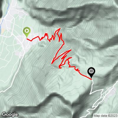
Passo di Santa Barbara climbs 14.0 km (8.7 mi) from Bolognano, on the edge of Arco at the northern end of Lake Garda, gaining 1066 m (3,498 ft) at a 7.3% average to the pass at 1170 m (3,839 ft). The road, the SP 48 del Monte Velo, works its way up the steep western face of Monte Velo in an almost endless series of hairpins before topping out at the little settlement of Santa Barbara, above the Val di Gresta.
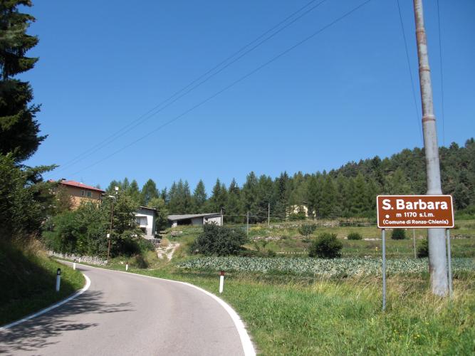
The first 9 km (5.6 mi) are the story here - they average about 9% with barely a let-up, starting with a signed 15% ramp just above Bolognano. The road climbs mostly through broadleaf woods, with openings over La Busa, the basin around Arco and Riva del Garda, and the lake beyond; some of the hairpins even carry names on their retaining walls, given to them by the people of Bolognano below. After a short downhill, the final kilometers ease off past the houses of Monte Velo and out into open fields of vegetables near the top.
This was the first of five categorized climbs on Stage 16 of the 2023 Giro d'Italia, rated category 1 on the day with the most climbing of that year's race, which finished on Monte Bondone with a win for João Almeida.
PLAN YOUR ROUTE
 We've partnered with Sherpa-Map.com to bring you the best route planning tool. With a PRO Membership you can use this climb as a reference when creating your route.
 From Bolognano at 134 m (440 ft), the climb covers 14.0 km (8.7 mi) and gains 1066 m (3,498 ft) at an average of 7.3%, with only about 40 m (132 ft) of descending along the way.
The first 9 km (5.6 mi) average about 9%, and none of them is easier than 7.5%. Kilometers 4 and 5 are the toughest at 10.3% and 10.1%, and short ramps go steeper still.
Just past km 9 the road dips briefly downhill, then the final 4 km (2.5 mi) are noticeably easier, averaging between 5% and 8% per kilometer to the pass.
The steepest kilometer averages 10.6%, the steepest 0.5 km 11.5%, the steepest 2 km 10.2%, the steepest 5 km 9.5%, and the steepest 10 km 7.8%.
Roadway: The SP 48 del Monte Velo is paved all the way, well surfaced and roughly a lane and a half wide, with many tight hairpins. In July 2024 the section between km 3.25 and 5.5 above Bolognano was closed for about two weeks for urgent landslide repairs and repaving. Check the Provincia autonoma di Trento's road bulletins before you go.
Traffic: Light on the climb itself - it's a quiet mountain road serving the Monte Velo houses, a few mountain huts, and the Val di Gresta beyond. Expect more traffic on the valley roads around Arco on the way to the start.
Parking: Arco has a free car park on its ring road at the roundabout at the end of Bolognano, right by the start of the climb. Paid car parks, run by AMSA, are closer to Arco's center.
Provisions: Fill your bottles in Bolognano - there's a fountain on the right side of the road at the start of the climb. The only other water on the way up is a fountain beside the small church at Salve Regina, at about 560 m. There's also a viewpoint over Lake Garda across the road from it. Beyond that, plan to be self-sufficient until the top.
Gear: The first 9 km at around 9% call for low gearing - bring your easiest gears. The woods give some shade, but on a hot Garda summer day carry two full bottles, and pack a light layer for the long, twisting descent.
Before heading out on any cycling adventure check out our Things to Bring on a Cycling Trip and use our interactive check list to ensure you don't forget anything.
Arco is the base for this climb - a relaxed town in the Sarca valley just north of the lake, known for the castle ruins on the rock above the old town and as one of Europe's great sport-climbing destinations. It's less busy than Riva del Garda or Torbole on the lakeshore, a few kilometers south.
Over the top, Santa Barbara has a small church dedicated to the saint, and it's the start of a hiking trail up Monte Stivo. Beyond it lie Ronzo-Chienis and the Val di Gresta, known for its vegetable gardens. The 2023 Giro route continued from here over Passo Bordala toward Monte Bondone - a big day if you want to follow it.
Garda Trentino is packed with serious climbs within a short ride. See what else is nearby, or build a custom route from here, with our Routes in the Area tool.
ROUTE MAP
MEMBER RATING
CURRENT WEATHER
PJAMM TRIPS ADVENTURE STARTER BUNDLES
Check out PJAMM Adventure's prepackaged (self-guided) cycling trips. They will help you plan, document and conquer your next adventure.
NEARBY CLIMBS (0) RADIAL PROXIMITY
FROM No Climbs Found
MEMBER REVIEWS & COMMENTS
Let us know what you thought of this climb. Signup for our FREE membership to write a review or post a comment.
Already have an account?
LOG IN HERE
