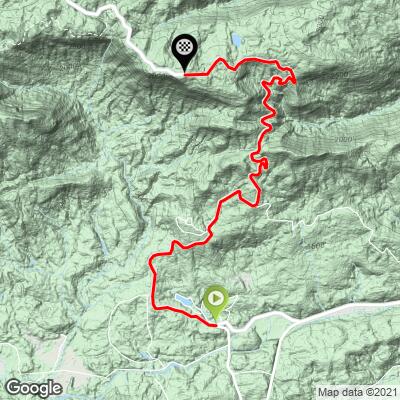
Caesars Head  Bike Climb - PJAMM Cycling

3.7
FIETS
6.5 mi
DISTANCE
2,067 ft
GAINED
5.9 %
AVG. GRADE

FULL CLIMB STATS

Page Contributor(s): John Summerson, The Complete Guide to Climbing (By Bike), 2nd Edition

INTRO

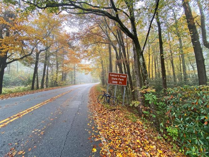
"Caesars Head (Route 276) is a surprisingly tough ascent in western South Carolina to a scenic state park.  On weekends you will see a good number of area riders on this hill.  Fairly shallow to start, the grade soon gets steeper and stays that way for the majority of the hill.  The route is mostly through thick woods and over a narrow road as well.  The maximum grade is contained within a tight turn to the right.  From there to the top the grade is variable but mostly solid and you may encounter a bit of traffic on good weather weekends as well..." (This quote is presented with the approval of John Summerson, from his book, The Complete Guide to Climbing (by Bike) in the Southeast, pg. 103.)
The average grade is 5.9% but increases to 6.5% when we eliminate descent.  70% of the climb is in the 5-10% range.  Steepest quarter-mile is 9.2% and steepest mile 8.1%. 
Roadway: Two lane highway in good condition with no shoulder. 

Traffic:  Mild to moderate depending on the time of day. 

Parking:  At the start of the climb - MapStreet View.
Provisions:  Vending machines with snacks and beverages at the visitor center at the finish of the climb. 
Before heading out on any cycling adventure check out our Things to Bring on a Cycling Trip and use our interactive check list to ensure you don't forget anything.
Be sure to walk out to the viewing platform at the Visitor Center as we are told it has wonderful views of the Blue Ridge Mountains (it was overcast during our ride). 

ROUTE MAP

MEMBER RATING

Difficulty: Moderate
4
Road
3
Traffic
3
Scenery

CURRENT WEATHER

PJAMM TRIPS ADVENTURE STARTER BUNDLES

Check out PJAMM Adventure's prepackaged (self-guided) cycling trips. They will help you plan, document and conquer your next adventure.
ALL TRIPS
Browse all of our prepackaged trips and find your next adventure!

NEARBY CLIMBS (0) RADIAL PROXIMITY

FROM
No Climbs Found

MEMBER REVIEWS & COMMENTS

Let us know what you thought of this climb. Signup for our FREE membership to write a review or post a comment.
Already have an account?

May 18, 2021
difficulty: Moderate
scenery: 3
traffic: 3
road: 4
May 18, 2021
scenery: 3
traffic: 3
road: 4
This long not-so-steep climb is part of the AOTC annual event route.
ROUTE MAP
PROFILE TOOL
Route Data
S.G. (%)
hide
Segment Data
hide

Climb Profile Not Found
CLIMB SUMMARY

Cycling Caesars Head, South Carolina - densely tree-lined two-lane road, yellow fall foliage, sign for Caesars Head State Park

Cycling Caesars Head, South Carolina.

Ride 6.5 miles gaining 2,059’ at 5.9% average grade.

This climb is into Caesars Head State Park to its visitor center.  We are surrounded by trees the entire climb, so we have no distant views.  However, particularly during the fall, the scenery on the climb can be exceptional.  

Cycling Caesars Head, South Carolina - road signs coming into the park

“Caesars Head (Route 276) is a surprisingly tough ascent in western South Carolina up to a scenic state park.  On weekends you will see a good number of area riders on this hill.  Fairly shallow to start, the grade soon gets steeper and stays that way for the majority of the hill.  The route is mostly through thick woods and over a narrow road as well.  The maximum grade is contained within a tight turn to the right.  From there to the top the grade is variable but mostly solid and you may encounter a bit of traffic on good weather weekends as well.  The last 2 miles are over very steady grade and within a tunnel of trees and the State Park parking lot on the left just before climb top may be a welcome site.  The listed climb ends at the upper end of the State Park Visitors Center parking lot.  At the top take the short walk to perhaps the most scenic overlook in the Southeast.” (This quote is provided with the approval of John Summerson from his book, The Complete Guide to Climbing (by Bike) in the Southeast, pg. 103.)

Cycling Caesars Head, South Carolina - climb grade and profile from PJAMM Adventure app

The steepest half mile on this climb is 9%.

The climb begins at the junction of Routes 8 and 276.  We ride on Geer Highway (State Route 276) the entire climb.  The roadway surface throughout the climb is excellent.  There is no shoulder to ride in, but on the day we cycled this route, the moderate traffic we encountered drove at a cautious rate and gave us reasonable space.

Cycling Caesars Head, South Carolina - photo collage,  densely tree-lined two-lane roadway, fall foliage and greenery, signs for Caesars Head Park, PJAMM Cycling logo in corner

Cycling Caesars Head, South Carolina - photo collage, inside and outside of Caesars Head State Park Visitor's Center, PJAMM Cycling logo in corner

Caesar Head Visitor Center is at the end of this climb.

Access to full Climb Summary requires a PJAMM Cycling PRO Membership!

It takes less than a minute to sign up & with your PRO membership you can:
  • Rate climbs, post comments and share your experiences on any of our climb pages
  • Create bucket lists of climbs & mark the dates you complete them
  • Weather data for all climbs - Start & Finish
  • Upload photos to your member page to customize your PJAMM Cycling experience
  • Utilize all of our interactive tools - Profile & Routes in Area
  • Download climb route .gpx files
LEARN MORE
SIGN UP

Already have an account? LOG IN HERE