
20.8
PDI
9.2 mi
DISTANCE
3,354 ft
GAINED
6.9 %
AVG. GRADE
FULL CLIMB STATS
INTRO
PLAN YOUR ROUTE
 We've partnered with Sherpa-Map.com to bring you the best route planning tool. With a PRO Membership you can use this climb as a reference when creating your route.
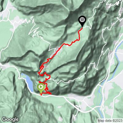
Passo Bordala is 14.9 km (9.2 mi) long and gains 1,022 m (3,354 ft) at a 6.9% average, rising from 233 m (765 ft) at Loppio to 1,254 m (4,114 ft) at the pass.
Km 0-9: the Val di Gresta approach to Ronzo-Chienis. Whole kilometers alternate between 4.7% and 8.3%, with the toughest at 1-2 km (8.3%) and 6-7 km (8.1%); the 7-8 km stretch (4.7%) is a welcome breather.
Km 9-14.9: beyond Ronzo-Chienis, the final 4.6 km (2.9 mi) to the pass runs between 5.4% and 8.7%, with the 11-12 km stretch the steepest whole kilometer at 8.7%, easing to 5.4% near the pass.
Steepest sections: 100 yd (91 m) at 12.5%; 0.5 km (0.3 mi) at 10.9%; 1 km (0.6 mi) at 10.1%; 1 mi (1.6 km) at 8.6%; 2 km (1.2 mi) at 8.3%; 5 km (3.1 mi) at 7.6%.
Roadway: The SP88 della Val di Gresta is paved the whole way and is wide for a mountain road, with plenty of curves. Between April and late October 2026, the Provincia autonoma di Trento is widening a stretch of the SP88 on the Isera side of the pass from 4 m to 6 m (13 ft to 20 ft), with new retaining walls, drainage and resurfacing. During the works the road there is closed to vehicles on weekdays from 7:00 to 12:00 and 13:00 to 18:00 and open without limits on weekends and holidays; the pass remains reachable from the Ronzo-Chienis side. The road between the pass and the SP20 toward Lago di Cei is closed to articulated lorries and coaches because it is narrow. If you plan to ride down the east side, check the Provincia's road notices first.
Traffic: The first kilometers share the Loppio junction area with SS240 traffic toward Riva del Garda and the Val di Ledro. Once you turn onto the SP88, the road carries mostly local traffic, farm vehicles and visitors heading for the Monte Stivo and Bordala trails.
Parking: Loppio is a road junction rather than a trailhead with its own car park; Mori, the municipality it belongs to, is the larger place for services. At the top, an albergo stands in the open forest at the pass.
Gear: A compact crank and a 30- or 32-tooth cog are comfortable here, with steady 7% to 8% sections and a few ramps just above 10%. Bring a layer for the descent - the pass is shaded and cooler than the lake.
Provisions: Ronzo-Chienis is the last village before the pass, and an albergo stands at the top. Carry enough water and food from the valley.
Before heading out on any cycling adventure check out our Things to Bring on a Cycling Trip and use our interactive check list to ensure you don't forget anything.
The Val di Gresta is known for its organic vegetables, with an autumn market-fair selling natural produce, so it rewards a slow ride through its villages. The pass is also the trailhead for the walk up Monte Stivo (2,059 m / 6,755 ft), and Monte Biaena (1,700 m / 5,577 ft) is another hike from here.
The pass also opens the east side: the descent toward Castellano and Rovereto is narrower than the Ronzo side, with tight turns under a limestone crest and a bike path along the Adige at the bottom. Passo di Santa Barbara and Monte Varagna are the other big climbs of the Garda Trentino, and combining Bordala with Santa Barbara follows the line of the 2023 Giro stage.
See what else is nearby, or build a custom route from here, with our Routes in the Area tool.
ROUTE MAP
MEMBER RATING
CURRENT WEATHER
PJAMM TRIPS ADVENTURE STARTER BUNDLES
Check out PJAMM Adventure's prepackaged (self-guided) cycling trips. They will help you plan, document and conquer your next adventure.
NEARBY CLIMBS (0) RADIAL PROXIMITY
FROM No Climbs Found
MEMBER REVIEWS & COMMENTS
Let us know what you thought of this climb. Signup for our FREE membership to write a review or post a comment.
Already have an account?
LOG IN HERE
