
20.8
PDI
7.9 mi
DISTANCE
3,139 ft
GAINED
7.6 %
AVG. GRADE
FULL CLIMB STATS
INTRO
PLAN YOUR ROUTE
 We've partnered with Sherpa-Map.com to bring you the best route planning tool. With a PRO Membership you can use this climb as a reference when creating your route.
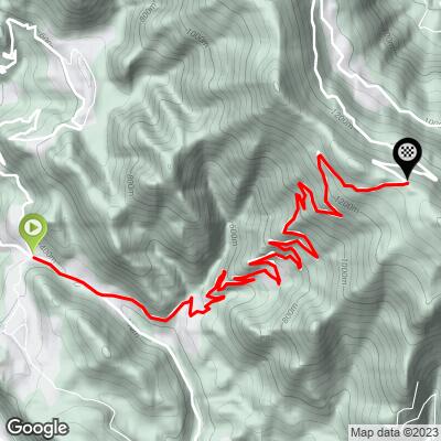
Valico di Valcava climbs 12.7 km (7.9 mi) from 361 m (1,184 ft) to 1317 m (4,320 ft), a gain of 957 m (3,139 ft) at an average grade of 7.6%.
The opening is gentle: 4.2% in the first kilometer, 2.5% in the second and 5.9% in the third. From km 3 to km 8 the road holds a steady 7.0% to 8.2%. Then the climb changes character, with the kilometers between km 8 and km 11 running 10.9%, 10.5% and 11.0% in succession. The grade eases to 8.7% in the twelfth kilometer, and the final 0.7 km (0.4 mi) runs about 7.2%.
The steepest 100 yd (91 m) reaches 17.2%, the steepest 0.25 mi (0.4 km) averages 14.2%, the steepest 0.5 km (0.3 mi) 13.5%, and the steepest kilometer (0.6 mi) 12.5%. The steepest mile (1.6 km) averages 11.7%, the steepest 2 km (1.2 mi) 11.7%, the steepest 5 km (3.1 mi) 9.8%, and the steepest 10 km (6.2 mi) 8.7%.
Roadway: The climb is paved all the way to the pass on a narrow road with tight corners through the steep upper section. The descent into either valley needs real care, especially on the 17% wall, so keep your speed down and your hands ready on the brakes.
Traffic: Valcava is a well-known training climb for riders from Lecco and Bergamo, so on dry weekends you will share the road with other cyclists as well as local cars and motorbikes. It is generally calmer on weekdays.
Parking: Torre de' Busi's village center is a well-known meeting point for area cyclists and the easiest place to leave a car, with Favirano a short roll down the valley from it. If you travel by train, Vercurago station is the start of a popular loop that includes the climb.
Gear: Bring your easiest gears. A compact crankset with a 30- to 32-tooth cassette makes the 10.5% to 11.0% kilometers and the wall near 17% manageable.
Provisions: Fill your bottles in Torre de' Busi before you start. A kiosk near the top serves coffee, but carry what you need for the climb and keep a windproof layer for the exposed descent.
Before heading out on any cycling adventure check out our Things to Bring on a Cycling Trip and use our interactive check list to ensure you don't forget anything.
Valcava is the sort of ride a Lombard weekend is built around. The classic loop from Vercurago station runs about 46 km (28.7 mi) with roughly 1370 m (4,495 ft) of climbing, crossing the Adda river at Ponte di Brivio.
The Giro d'Italia stage that crossed Valcava in 2012 finished at Pian dei Resinelli above Lecco, and the same ridge system is full of climbs for a longer trip. On the Bergamo side, the Roncola Alta climb reaches the same Valle Imagna approach as the easier way over the pass, so the two make a natural pairing across a weekend.
Our Routes in the Area tool shows the other climbs around Lecco and Bergamo that fit into a day on either side of Valcava.
ROUTE MAP
MEMBER RATING
CURRENT WEATHER
PJAMM TRIPS ADVENTURE STARTER BUNDLES
Check out PJAMM Adventure's prepackaged (self-guided) cycling trips. They will help you plan, document and conquer your next adventure.
NEARBY CLIMBS (0) RADIAL PROXIMITY
FROM No Climbs Found
MEMBER REVIEWS & COMMENTS
Let us know what you thought of this climb. Signup for our FREE membership to write a review or post a comment.
Already have an account?
LOG IN HERE
