
18.1
PDI
28.5 mi
DISTANCE
4,963 ft
GAINED
2.4 %
AVG. GRADE
FULL CLIMB STATS
INTRO
PLAN YOUR ROUTE
 We've partnered with Sherpa-Map.com to bring you the best route planning tool. With a PRO Membership you can use this climb as a reference when creating your route.
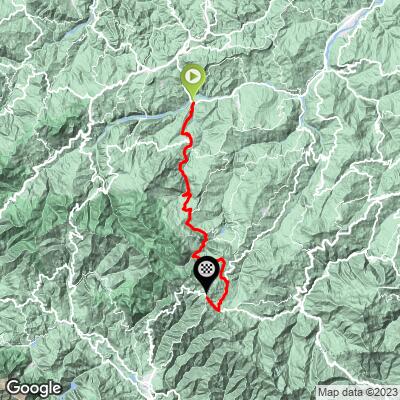
Passo delle Radici averages just 2.4% over 45.8 km (28.5 mi), but with 1513 m (4,963 ft) of climbing and 397 m (1,304 ft) of descending, it rides like several climbs strung together.
The first 14 km (8.7 mi) roll gently upward through Villa Minozzo at about 2.3%, with a few short descents.
The first real climb starts around km 14: the road up the Val d'Asta gains about 347 m (1,138 ft) in 6 km (3.7 mi) at 5.8%, and contains the steepest 5 km (3.1 mi) of the route, at 6.1%.
From km 20 to Civago, around km 28 (17.4 mi), the road loses height overall on a series of descents and short rises. From Civago the SP38 climbs 9 km (5.6 mi) at about 3.2%, including one steeper kilometer at 7.1%, before a 2.3 km (1.4 mi) descent into Piandelagotti.
The final 6.5 km (4.0 mi) from Piandelagotti climb at 4.5% and save the hardest for last: the final 3 km (1.9 mi) average 6.9%, with the steepest kilometer of the whole route at 8.5% and a 0.5 km (0.3 mi) stretch at 8.9%.
Roadway: Paved throughout, on a patchwork of roads: local roads and the SP9 around Villa Minozzo, the narrow, winding Val d'Asta and Sommaterra roads to Civago, the SP38 to Piandelagotti, and the wider SP486R for the final kilometers to the pass. Landslide-related closures do happen in these Apennine valleys, so check the provinces of Reggio Emilia and Modena for road notices before committing to a long day out.
Traffic: Light for nearly the whole route. Riders describe the pass as almost traffic-free, and the minor roads between Asta and Civago carry mostly local cars. Expect a little more traffic on the SP486R between Piandelagotti and the pass, the main road over the Radici.
Parking: The start is a rural spot below Villa Minozzo, so the practical choice is to park in Villa Minozzo itself, the municipal town about 6 km (3.7 mi) up the route, and ride back down to the start. This is a long point-to-point route, so plan your return or arrange a support car - Civago and Piandelagotti both make natural meeting points along the way.
Provisions: Villa Minozzo has full services early on. Civago, about 28 km (17.4 mi) in, has the Albergo Val Dolo hotel-restaurant on its main square, and Piandelagotti, around km 39 (24.2 mi), is the last village before the pass. Carry two bottles - there are long stretches between villages with no reliable water.
Gear: A compact is plenty for grades that rarely pass 8%, but the real challenge is length, so bring enough food for a 45.8 km (28.5 mi) climb. The pass is more than 1,100 m (3,609 ft) higher than the start and often much cooler, so pack a jacket for the descent or the ride home.
Before heading out on any cycling adventure check out our Things to Bring on a Cycling Trip and use our interactive check list to ensure you don't forget anything.
Civago is the place to stretch your legs off the bike. A steep but well-marked path climbs about an hour and a half from the village to the Rifugio Segheria dell'Abetina Reale (1410 m / 4,626 ft), named for an old sawmill in the heart of the Abetina Reale fir forest inside the national park; it's open year-round and serves good mountain food. Above the whole area rises Monte Cusna (2,121 m / 6,959 ft), the highest peak in the province of Reggio Emilia.
Piandelagotti is best known for its Boscoreale cross-country ski center, with about 40 km (24.9 mi) of trails, and for its high-altitude potatoes, grown here since 1925 and celebrated with their own festival. Over the pass, San Pellegrino in Alpe is worth the short detour: its Museum of Rural Life fills 14 rooms of a 14th-century pilgrims' hospice with more than 4,000 objects from Apennine mountain life, and the sanctuary next door holds the remains of Saints Pellegrino and Bianco. The pass is more than 1,100 m (3,609 ft) above the start and can be much colder and windier than the valley - check current conditions before you go with our Weather tool.
ROUTE MAP
MEMBER RATING
CURRENT WEATHER
PJAMM TRIPS ADVENTURE STARTER BUNDLES
Check out PJAMM Adventure's prepackaged (self-guided) cycling trips. They will help you plan, document and conquer your next adventure.
NEARBY CLIMBS (0) RADIAL PROXIMITY
FROM No Climbs Found
MEMBER REVIEWS & COMMENTS
Let us know what you thought of this climb. Signup for our FREE membership to write a review or post a comment.
Already have an account?
LOG IN HERE
