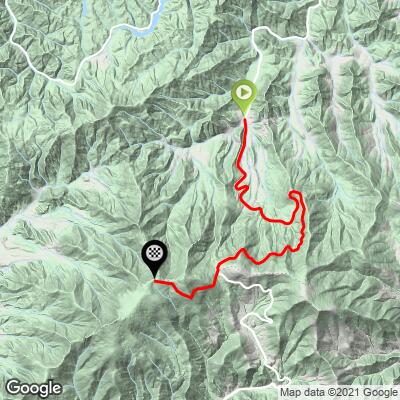
Roan Mountain North Bike Climb - PJAMM Cycling

7.3
FIETS
9 mi
DISTANCE
3,180 ft
GAINED
6.7 %
AVG. GRADE

FULL CLIMB STATS

Page Contributor(s): Dan Razum, Campbell, CA, USA.
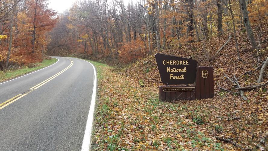
INTRO

This is a challenging climb ending at popular Roan High Knob Trail.  We finish the climb in North Carolina at the Appalachian Trail. 

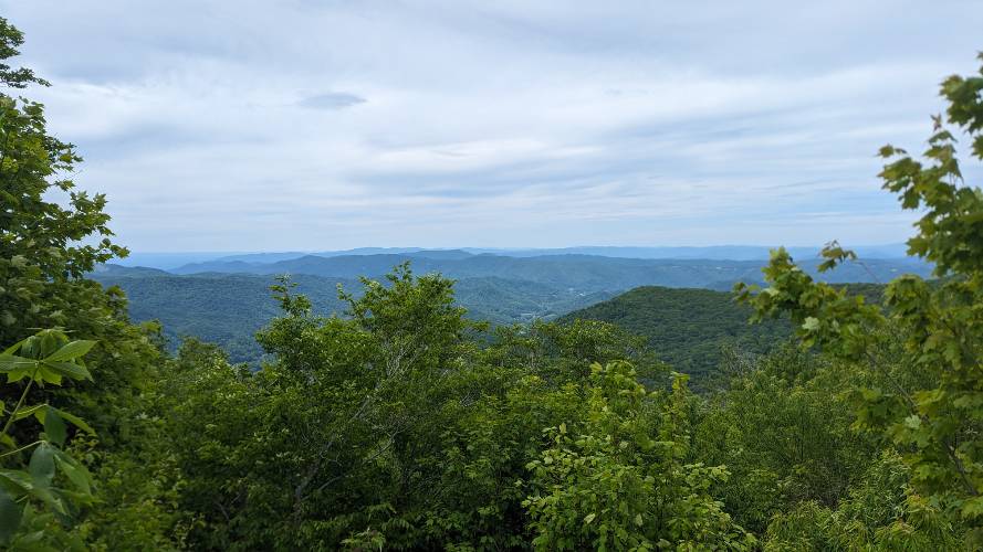
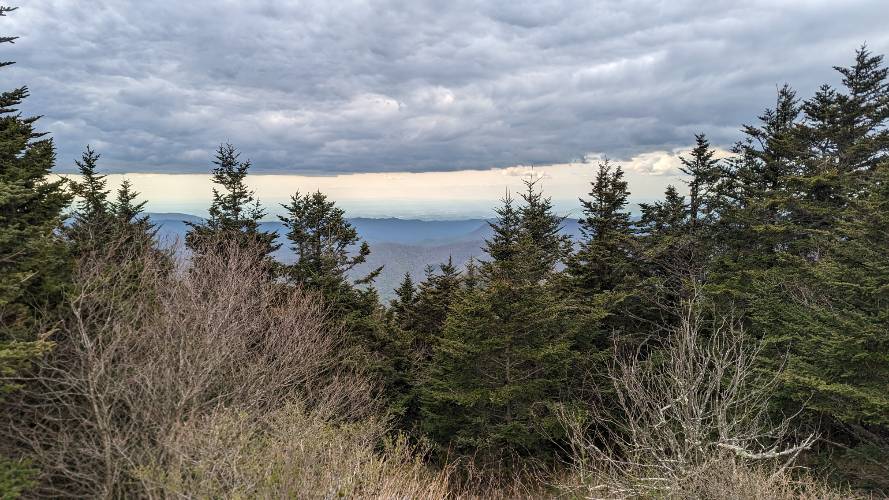
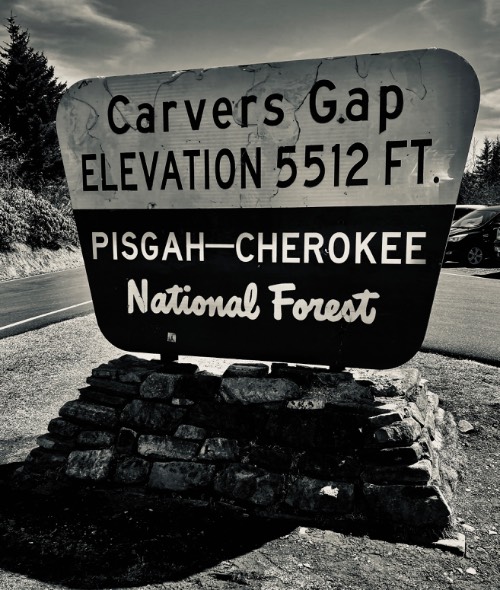
"The north side of Roan Mountain is one of the most difficult in the Southeast.  Steeper over its bottom half, the road switchbacks up the hill under a tunnel of trees with some good views near the top.  At mile 7.5 (Carvers Gap) enter North Carolina and turn right on Roan Mountain Road for the final 1.5 miles before ending at a tollbooth.  This side of Roan Mountain is a quick in places descent as well." (This quote is presented with the approval of John Summerson, from his book, The Complete Guide to Climbing (by Bike), 2nd Edition, pg. 116.)
6.6% average grade.  63% of the climb is at 5-10% grade and 10% is at 10-15%.  The steepest quarter-mile is 10.6%.

See more details and tools regarding this climb's grade via the “Profile Tool” button.
Roadway:  Two lane highway with minimal to no shoulder.  The roadway surface is in good conditoin. 

Traffic:  Mild.

Parking:  There is plenty of parking at the start of the climb - MapStreet View.  
Provisions:  There is a gas station at the start of the climb that has snacks and beverages.  Ha, ha - it's even called Jack's Petrol & Provisions - Map.
Before heading out on any cycling adventure check out our Things to Bring on a Cycling Trip and use our interactive check list to ensure you don't forget anything.
Bring a cable and bike lock and do a short hike that is highly regarded at the finish: Roan High Knob - Google Reviews.

ROUTE MAP

MEMBER RATING

Difficulty: Challenging
3
Road
4
Traffic
3.5
Scenery

CURRENT WEATHER

PJAMM TRIPS ADVENTURE STARTER BUNDLES

Check out PJAMM Adventure's prepackaged (self-guided) cycling trips. They will help you plan, document and conquer your next adventure.
ALL TRIPS
Browse all of our prepackaged trips and find your next adventure!
Smoky Mountain National Park
United States (NC,TN)
17 ROUTES
31 POIs
ROUTE STATS (TOTAL)
181.8
mi
DISTANCE
34,253
ft
ELEV. GAIN
The Blue Ridge Parkway (North)
United States (NC,TN,VA)
38 ROUTES
70 POIs
ROUTE STATS (TOTAL)
716.5
mi
DISTANCE
75,697
ft
ELEV. GAIN
The Blue Ridge Parkway (South)
United States (NC,TN,VA)
30 ROUTES
63 POIs
ROUTE STATS (TOTAL)
690.7
mi
DISTANCE
74,180
ft
ELEV. GAIN

NEARBY CLIMBS (0) RADIAL PROXIMITY

FROM
No Climbs Found

MEMBER REVIEWS & COMMENTS

Let us know what you thought of this climb. Signup for our FREE membership to write a review or post a comment.
Already have an account?

Mar 6, 2022
difficulty: Challenging
scenery: 3
traffic: 4
road: 3
Mar 6, 2022
scenery: 3
traffic: 4
road: 3
First 3 miles of the climb doesn’t budge. Through the rock gap, the downslope winds revealed themselves. Carvers Gap was max capacity with vehicles and AT hikers. No one beyond the gate for a quiet jaunt up to the top. The rain jacket came out for a chilly descent. The downward side of the North route’s road is pot holed and chatty. Coupled with the stiff winds, it was a conservative ride down.
Mar 22, 2021
difficulty: Challenging
scenery: 4
traffic: 4
road: 3
Mar 22, 2021
scenery: 4
traffic: 4
road: 3
One of the top climbs in the Southeast and a true category 1 ascent. Solid almost all the way up, you ride through thick woods before breaking out closer to the junction (Carvers Gap). A bit hard to get to but well worth the effort.
ROUTE MAP
PROFILE TOOL
Route Data
S.G. (%)
hide
Segment Data
hide

Climb Profile Not Found
CLIMB SUMMARY

Roan Mountain North Climb Summary

Thanks much to Dan Razum, Campbell, CA for his excellent photo and written summary of this climb.

You can start riding at the town of Roan Mountain, where route 143 begins . . .

Longer route start - town of Roan

. . . .or you can also start at Roan Mountain State Park, a couple of miles south of the town along route 143. There are several parking lots in the State Park. 


Roan State Park 2 miles south of the town of Roan Mountain

Note:  PJAMM’s “climb” begins further south of Roan Mountain where the road pitches up for the duration (~ 5 miles south of the town of Roan Mountain).

Route 143 is a 2 lane road that starts off with a wide shoulder but that only lasts about a half a mile.

After that, there is no shoulder.


No shoulder after ½ mile.

The first 5 miles are rollers before starting the climb proper at the intersection with Burbank and Cove Creek roads.  


PJAMM’s Climb Start (intersection of Burbank and Cove Creek Roads).

This roller section passes through Roan Mountain State Park and has some sharp bends with limited visibility. You need to be careful because there can be moderate traffic in this area and the lack of shoulder makes it dangerous if a car comes up quickly around a bend. Route 143 is a typical narrow, twisty country road that is common throughout the Appalachian area. Bright clothing and a rear tail light is highly  recommended when riding any country road and mirrors are also very helpful.  In the roller section, I encountered a car every 2 or 3 minutes, so the traffic isn't heavy but you still need to be careful.  During the climb (last 9 miles of my climb)  there was less traffic, maybe one vehicle every 15 minutes and I did not encounter any vehicles at all during the descent. That was a weekday in November; there is probably significantly more traffic during a summer weekend. The road surface throughout is smooth and in good condition.

The climb is enjoyable, not too steep and no sharp turns.  You start out going through a thick canopy of hardwood

trees, arching across the road.  


Tree canopy in beginning of climb (November colors).

About halfway up, the road gets closer to the side of the mountain and you start getting glimpses of the valley and surrounding moutains.


Views of the valley below higher up the climb.

The last mile before Carver's Gap has nice wide open  views.  Upon reaching Carver's Gap you turn right onto route 1348, a small two lane road going to Roan Mountain Gardens.


Carver’s Gap (mile 7.4 of PJAMM route / 12.5 miles from town of Roan Mountain)

This road is more narrow than 143, but the traffic would only be tourists, so I feel it would be safe during the tourist season.  The road closes for the winter, so there was no traffic at all in November.  However, you should still be careful, I encountered a pedestrian walking a dog on the descent.  And it's possible that deer or other wildlife could run across the road. The trees change to coniferous around Carver's Gap; riding up 143 is hardwood forest and riding up 1348 is pine forest.


Alpine setting last few miles.

At the end of 1348 there is a toll booth to collect parking fees, but no mention of bicycles, so I don't know if

there is a fee for bikes or not. However, the toll booth is essentially the end of the road, there isn't any paved climbing

or views afterwards.

Toll booth at 14.7 miles from Roan Mountain - Finish of PJAMM’s route.

Beyond the toll booth you can turn right into the parking lot or turn left towards Roan Gardens and bus parking.  To the left it is a gravel road, but fairly smooth, passable with a road bike. 


Easily navigated on a road bike.

The gravel road goes about a mile before ending at the trail head to Roan High Bluff. Since there are no great views after the toll booth due to the high vegetation, there probably isn't much point to ride the gravel portion, unless, perhaps, it is summer and the rhododendrons are in bloom.


End of the gravel road.

The best views are on 143, in the mile before reaching Carver's Gap. There are also some views of the North Carolina side from 1348, about 1/2 mile before the toll booth.