

16.4
PDI
6.7 mi
DISTANCE
2,531 ft
GAINED
7.1 %
AVG. GRADE
FULL CLIMB STATS
INTRO
Zoppè di Cadore is a comune of fewer than 300 people, a cluster of hamlets at about 1460 m on the southern slopes of Monte Pelmo, and this road up from Forno di Zoldo is the way in. It goes nowhere else, so there's almost no traffic, and it's about as regular as a mountain road gets: after an easy second kilometer through Bragarezza and Villanova, almost every kilometer to the top sits between 7% and 8%.
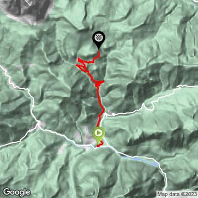
Our route runs 10.8 km (6.7 mi) from 828 m to 1593 m (2718 to 5226 ft), gaining 771 m (2531 ft) at a 7.1% average. Most of it is forest and hairpins - riders count about a dozen - with the occasional gap in the trees looking back across the Val di Zoldo. The village comes after about 9 km. The road keeps going above it as a narrow lane with a wooden fence on the drop side and a wayside shrine on the last bend, and from the finish you look straight down on Zoppè's church spire with the Dolomites stacked up behind it.
It's not a pass, so you'll ride back the way you came. It's short enough to pair with Passo Cibiana, which starts from the same corner of Forno di Zoldo, or with Passo Staulanza and Passo Duran up the valley.
PLAN YOUR ROUTE
 We've partnered with Sherpa-Map.com to bring you the best route planning tool. With a PRO Membership you can use this climb as a reference when creating your route.
Zoppè di Cadore climbs 771 m (2531 ft) in 10.8 km (6.7 mi), from 828 m to 1593 m (2718 to 5226 ft), at a 7.1% average.
The first kilometer out of Forno di Zoldo averages 6.4% and the second eases to 4.2%. After that the climb barely changes: kilometers 3 to 10 all average between 7.2% and 8.1%, and the last 800 m above the village average 6.7%.
The steepest kilometer averages 9.6%, and a few hairpins have short ramps - the steepest 100 m reach 18% - but they're over in a few pedal strokes.
Roadway: Paved throughout: the SP7 from Campo up through Bragarezza and Villanova to Zoppè, then narrow village lanes through Villa and Bortolot and a single-lane paved road above the village to the finish. The SP7 is narrow with tight hairpins in the forest, and the top section is barely a car wide. At this altitude, snow and ice are likely once autumn turns cold, and well into spring.
Traffic: Very light. Zoppè is a dead end, so you'll mostly meet residents, delivery vans and hikers heading for the Pelmo trails. Watch for cars on the blind hairpins on the way down.
Parking: Forno di Zoldo is the base - park in town and roll the short distance to Campo, where the SP7 starts. Space in Zoppè itself is tight, so don't plan on driving up to start from the top. If you're coming in by car from Longarone, note that the SP251 through the Soffranco gorge has been closed by rockfall before; Passo Cibiana and Passo Duran are the other ways into the valley.
Gear: Eight kilometers at 7-8% call for a gear you can sit and spin all the way up - a compact with a 32 at the back is about right. The finish is close to 1600 m and the descent is mostly in the forest shade, so carry a layer.
Provisions: Forno di Zoldo has bars and shops; fill up there. Zoppè is tiny, so don't count on finding anything open in the village.
Before heading out on any cycling adventure check out our Things to Bring on a Cycling Trip and use our interactive check list to ensure you don't forget anything.
Zoppè punches above its size. It's said to be where the Zoldo valley's ice-cream trade began - villagers learned the craft from their Cadore neighbors and the skill spread down the valley, which went on to fill gelaterie all over Europe (our Passo Staulanza (Dont) page tells the valley's story). The parish church of Sant'Anna, begun in 1530, holds a painting attributed to Titian or his pupils, and the 20th-century painters Masi Simonetti and Fiorenzo Tomea are both closely tied to the village.
The village is also a trailhead for Monte Pelmo: a path leads up to Rifugio Venezia on the mountain's south side, a few hours' walk from the village.
Back in Forno di Zoldo, Passo Cibiana starts almost from the same spot, and from the top of Cibiana the old military road climbs on to Monte Rite. Dont, a few kilometers up the valley, is where the Passo Duran and Passo Staulanza climbs begin.
ROUTE MAP
MEMBER RATING
CURRENT WEATHER
PJAMM TRIPS ADVENTURE STARTER BUNDLES
Check out PJAMM Adventure's prepackaged (self-guided) cycling trips. They will help you plan, document and conquer your next adventure.
NEARBY CLIMBS (0) RADIAL PROXIMITY
FROM No Climbs Found
MEMBER REVIEWS & COMMENTS
Let us know what you thought of this climb. Signup for our FREE membership to write a review or post a comment.
Already have an account?
LOG IN HERE
