

25.6
PDI
12.3 mi
DISTANCE
4,182 ft
GAINED
6.4 %
AVG. GRADE
FULL CLIMB STATS
INTRO
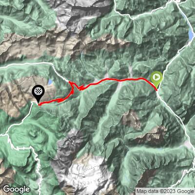
Passo Valles climbs 19.8 km (12.3 mi) from Cencenighe Agordino through the Biois valley and the town of Falcade to the pass at 2,037 m (6,683 ft), gaining 1,275 m (4,182 ft) at a 6.4% average grade. The road runs through the Listolade gorge before opening into the valley, then climbs through forest that thins into open alpine terrain in the final kilometers.
The payoff is the scenery: from the upper switchbacks and the pass itself, riders get sweeping views of some of the Dolomites' most recognizable peaks, including Marmolada, Civetta, and the Pale di San Martino group. Past the pass, the road continues about 6.4 km (4.0 mi) down to Passo Rolle, another well-known Dolomites climb, making this a natural link in a bigger day rather than an out-and-back.
Passo Valles first appeared in the Giro d'Italia in 1963 and was the race's Cima Coppi - its highest point that year - in 1978. It's a quieter alternative to some of its more famous Dolomite neighbors, with a similar scale of climbing and views but noticeably less traffic.
PLAN YOUR ROUTE
 We've partnered with Sherpa-Map.com to bring you the best route planning tool. With a PRO Membership you can use this climb as a reference when creating your route.
 Passo Valles gains 1,275 m (4,182 ft) over 19.8 km (12.3 mi) at a 6.4% average grade, finishing at 2,037 m (6,683 ft). The steepest kilometer averages 10.5% and the steepest mile 10.2%, with the hardest ramps concentrated in the final push above Falcade as the road switchbacks into open alpine terrain. The lower miles through the Biois valley and the Listolade gorge are comparatively gentle, so the climb builds steadily rather than front-loading its hardest grades.
Roadway: The SP346/SP641 is paved the entire way from Cencenighe Agordino to the pass and is generally in good condition. The one spot worth knowing about in advance is the Listolade tunnel near the start, just outside Cencenighe - it's legal and normal for cyclists to ride through, but it's poorly lit and has a real history of serious accidents, so use a bright front and rear light and reflective gear even in daytime. The old road alongside it is closed to motor traffic and not a sanctioned cycling alternative.
Traffic: Light to moderate through the Biois valley and Falcade, where the road carries local and tourist traffic in summer. Above Falcade, traffic drops off noticeably - this is a quieter pass than several of its Dolomite neighbors, even in peak season.
Parking: Free parking is available in Cencenighe Agordino near the start, and again in Falcade partway up if you'd rather begin the climb higher. There's a small parking area at the pass itself for anyone driving up to meet a rider.
The road is paved the entire way, so a standard road bike is fine; a compact crank helps on the steeper ramps above Falcade. Temperatures drop with the 1,275 m (4,182 ft) of elevation gain and wind picks up on the open alpine section near the pass, so pack an extra layer even in summer. Cencenighe Agordino and Falcade both have shops, cafes, and restaurants for stocking up along the way, so you don't need to carry everything from the start.
Before heading out on any cycling adventure check out our Things to Bring on a Cycling Trip and use our interactive check list to ensure you don't forget anything.
Falcade, about two-thirds of the way up, is a good spot to break up the ride - a small Dolomite town with cafes and shops that makes a natural stopping point before the steeper final kilometers to the pass. From the top, the road continues down to Passo Rolle, so riders looking for a bigger day can treat Passo Valles as a link rather than a turnaround point.
Passo Valles carries real Giro d'Italia pedigree - it debuted in 1963 and served as the race's Cima Coppi, its highest point that year, in 1978 - but sees noticeably less traffic than some of its better-known Dolomite neighbors. Check our Weather tool for current conditions at both the base and the pass before you go, since alpine weather here can turn quickly.
ROUTE MAP
MEMBER RATING
CURRENT WEATHER
PJAMM TRIPS ADVENTURE STARTER BUNDLES
Check out PJAMM Adventure's prepackaged (self-guided) cycling trips. They will help you plan, document and conquer your next adventure.
NEARBY CLIMBS (0) RADIAL PROXIMITY
FROM No Climbs Found
MEMBER REVIEWS & COMMENTS
Let us know what you thought of this climb. Signup for our FREE membership to write a review or post a comment.
Already have an account?
LOG IN HERE
