
21.1
PDI
9.3 mi
DISTANCE
3,414 ft
GAINED
6 %
AVG. GRADE
FULL CLIMB STATS
INTRO
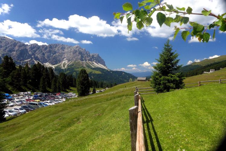
Passo delle Erbe (Würzjoch in German, Ju de Börz in Ladin) links Val Badia with the Eisack valley near Brixen, and this approach from San Martino in Badia is the Ladin-valley way up. The climb covers 14.9 km (9.3 mi) and gains 1,041 m (3,414 ft) at a 6.0% average, finishing just under 2,000 m (about 6,530 ft) at the foot of the Peitlerkofel (Sass de Putia, 2,875 m / 9,432 ft).
That average hides an uneven climb. The road climbs steeply out of the valley, running 9-12% from about the first kilometer to km 2.5, then eases as it crests near 1,550 m (5,085 ft) around the 6 km mark. A descent of roughly 115 m (380 ft) toward Antermoia follows, and then the climb restarts in earnest: the final 6.5 km hold 7-11% through spruce forest and hairpins before opening onto alpine pasture at the pass, with the Odle/Geisler peaks on the skyline. The steepest 100 yards touch 16.2%.
San Martino in Badia is regarded as the cradle of Ladin culture, and the municipality includes the villages of Piccolino, Longiarù and Antermoia. The pass can also be climbed from the Brixen side - see our Passo delle Erbe from Santa Maddalena page for the Val di Funes approach.
PLAN YOUR ROUTE
 We've partnered with Sherpa-Map.com to bring you the best route planning tool. With a PRO Membership you can use this climb as a reference when creating your route.
 The climb covers 14.9 km (9.3 mi) and gains 1,041 m (3,414 ft) at an average of 6.0%, but the road is anything but even. It climbs steeply out of the valley (9-12% from about the first kilometer to km 2.5), eases to a crest near 1,550 m (5,085 ft) at about km 6, then drops roughly 115 m (380 ft) between km 6 and km 8.5 before climbing about 550 m (1,800 ft) over the final 7 km to the pass.
That second climb is where the grade bites: the steepest 0.5 km averages 12.7%, the steepest 1 km 11.6%, the steepest 2 km 10.6% and the steepest 5 km 9.8%, with the sharpest 100 yards reaching 16.2%. Because the descent is counted, the steepest 10 km averages just 4.9% - don't let that number lull you.
Roadway: Paved the whole way, on a narrow mountain road with plenty of hairpins in the upper half. The pass is fully open from May through November; in winter the summit is reached only from the Val Badia side, so check conditions before riding in the shoulder seasons.
Traffic: Moderate to light. The Val Badia side is quieter than the big Dolomites passes nearby, but expect more cars and motorcycles on summer weekends, especially near the summit.
Parking: Start from the valley and leave the car in San Martino in Badia or neighboring Piccolino, where the climb begins at about 1,095 m. Roadside parking is prohibited along the pass road, and the paid car park shortly before the summit on the Val Badia side fills up quickly in high season, so it's best not to count on it.
Provisions: Fill bottles in the valley before you start, as services thin out once you leave the villages. The Ütia de Börz and other huts near the summit serve food and drinks in season.
Gear: Compact or wide-range gearing is well worth having for the 9-12% pitches. Bring a wind layer for the descent, since the summit sits close to 2,000 m (6,500 ft) and Dolomites weather can change quickly.
Before heading out on any cycling adventure check out our Things to Bring on a Cycling Trip and use our interactive check list to ensure you don't forget anything.
San Martino in Badia is worth a stop before you roll out. The Museum Ladin Ciastel de Tor explores the history and language of the Ladin valleys, and the Viles in the Val di Morins (valle dei Mulini) are among the oldest Ladin settlements in Val Badia. The peak that fills the view above the pass, the Peitlerkofel, has its own hiking circuits from the summit area, including the Roda de Pütia (4-5 hours) and the Maurerberg hut walk (3-4 hours).
The pass is part of the Puez-Odle (Puez-Geisler) Nature Park boundary, and the Brixen side has its own character - for that approach, see Passo delle Erbe from Santa Maddalena. Val Badia is packed with climbs, so you can see other climbs nearby with our Routes in the Area tool.
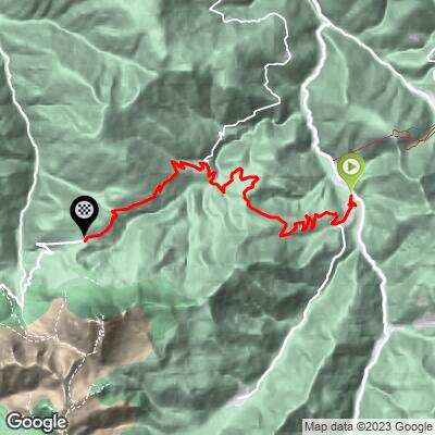
ROUTE MAP
MEMBER RATING
CURRENT WEATHER
PJAMM TRIPS ADVENTURE STARTER BUNDLES
Check out PJAMM Adventure's prepackaged (self-guided) cycling trips. They will help you plan, document and conquer your next adventure.
NEARBY CLIMBS (0) RADIAL PROXIMITY
FROM No Climbs Found
MEMBER REVIEWS & COMMENTS
Let us know what you thought of this climb. Signup for our FREE membership to write a review or post a comment.
Already have an account?
LOG IN HERE
Cyclopaat
One of three alternatives from the Val Badia end, the others starting north of this one, in Longega and Mantana. All have a serious drop, and all are hard, most climbing done at >9%.
