
28.9
PDI
18.7 mi
DISTANCE
5,511 ft
GAINED
4.8 %
AVG. GRADE
FULL CLIMB STATS
INTRO
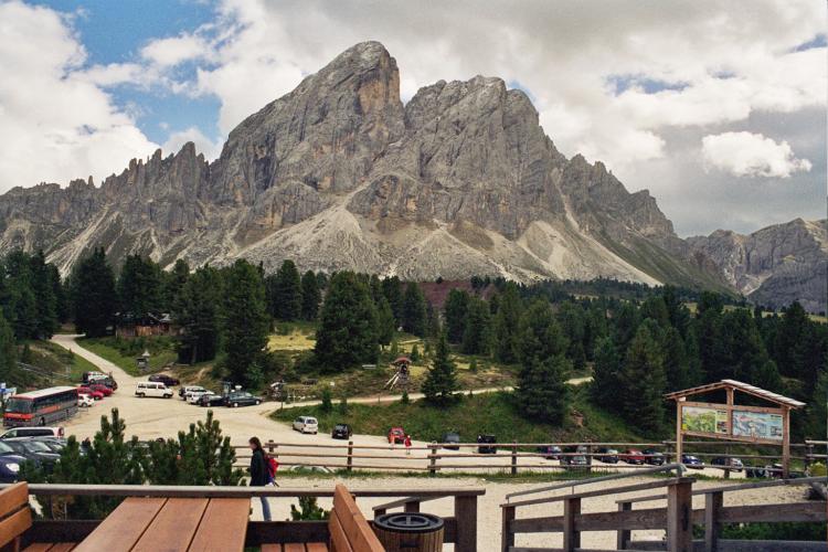
Passo delle Erbe (known in German as the Würzjoch) climbs out of the historic town of Bressanone (Brixen) in South Tyrol to a pass just under 2,000 m, at the foot of the striking Sass de Putia peak. From Bressanone it's 30.0 km (18.7 mi) at an average grade of 5.6%, gaining 1,680 m (5,511 ft) - one of the longer ascents in this part of the Dolomites.
The route climbs out of the wide Val Isarco/Eisacktal on a series of hairpins with sweeping views back over Bressanone, then settles into a quieter rhythm, winding village to village through pine forest past the turnoff to the Plose cable car station. The second half isn't a straight grind either - two short descents interrupt the climb before the final push back up to the pass, with the limestone spires of Sass de Putia (2,875 m) dominating the skyline the closer you get. The pass sits at the edge of the Puez-Odle Nature Park, part of the Dolomites UNESCO World Heritage Site, and connects the Val Isarco/Eisacktal to Val Badia on the other side.
We currently rank this climb #376 in the world. Bressanone itself, the start and a worthwhile base, is one of South Tyrol's oldest towns - its 10th-century cathedral and the adjoining Hofburg, now home to the Diocesan Museum, are both worth a visit before or after the ride.
The road is narrow throughout, with variable-quality asphalt on the upper, one-lane sections, and closes for winter - this is a warm-season climb only.
PLAN YOUR ROUTE
 We've partnered with Sherpa-Map.com to bring you the best route planning tool. With a PRO Membership you can use this climb as a reference when creating your route.
 Passo delle Erbe gains 1,680 m (5,511 ft) over 30.0 km (18.7 mi) at an average grade of 5.6% - but that average hides a genuinely uneven profile. The opening stretch out of Bressanone climbs in hairpins before easing into a long, rolling forest section, with gentle grades broken up by flatter and even briefly descending stretches. The second half is the harder half: two short descents force you to re-climb the lost elevation before the final ramp to the pass, and several route trackers report brief pitches into the 14-15% range on this closing section. Pace for a long day rather than a short, sharp effort.
Roadway: The lower section, out of Bressanone past the village of Sant'Andrea, is a well-paved two-lane road. Beyond the Plose cable-car turnoff the road narrows to one lane, with asphalt of variable quality the rest of the way to the pass. The road is closed in winter and is typically only rideable from late spring through early autumn.
Traffic: Light. What traffic there is thins out past the Plose turnoff just outside Sant'Andrea; above that point you'll mostly share the road with other cyclists and the occasional local car.
Parking: Bressanone's town center has public parking available near the old town and train station, a reasonable base for the ride out to Sant'Andrea and the start of the climb proper.
Provisions: Bressanone has full services - shops, cafes, restaurants - before you start. There's nothing else until the pass itself, which has a hotel/restaurant and a couple of rifugios where you can refuel before the descent.
Gear: At 30.0 km (18.7 mi) with 1,680 m (5,511 ft) of gain, plan for a long day in the saddle. The average grade is moderate, but the two descending sections mid-climb mean you'll re-climb ground more than once, and reported pitches into the 14-15% range near the top reward having a compact chainring and wide-range cassette in reserve.
Before heading out on any cycling adventure check out our Things to Bring on a Cycling Trip and use our interactive check list to ensure you don't forget anything.
Bressanone (Brixen) is one of South Tyrol's oldest towns and a worthwhile base for more than just this climb. The 10th-century Cathedral of Santa Maria Assunta and the adjoining Hofburg - the former bishop's palace, now the Diocesan Museum - sit in the compact old town, an easy walk from the train station. Just outside town, the Abbey of Novacella (Neustift) is a working Augustinian monastery with its own library and winery, open for tours and tastings.
At the summit, Passo delle Erbe/Würzjoch has a hotel, a restaurant, and a couple of rifugios, all looking out over Sass de Putia and the Puez-Odle Nature Park - a good excuse to linger before heading back down. See our Routes in the Area tool for other ways up to this same pass, including from San Martin de Tor and Val di Funes.
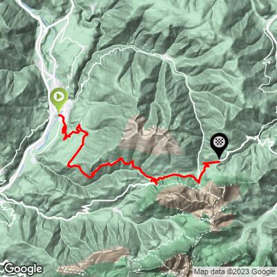
ROUTE MAP
MEMBER RATING
CURRENT WEATHER
PJAMM TRIPS ADVENTURE STARTER BUNDLES
Check out PJAMM Adventure's prepackaged (self-guided) cycling trips. They will help you plan, document and conquer your next adventure.
NEARBY CLIMBS (0) RADIAL PROXIMITY
FROM No Climbs Found
MEMBER REVIEWS & COMMENTS
Let us know what you thought of this climb. Signup for our FREE membership to write a review or post a comment.
Already have an account?
LOG IN HERE
Cyclopaat
One of three alternatives from the Valle Isarco end, this is probably the easiest. That doesn't make it easy, though, as this one is also irregular and has descents in it.
