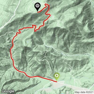
19.3
PDI
7.2 mi
DISTANCE
2,896 ft
GAINED
7.7 %
AVG. GRADE
FULL CLIMB STATS
Page Contributor(s): John Summerson, The Complete Guide to Climbing (By Bike), 2nd Edition; Dan Razum, Campbel, CA, USA.
INTRO
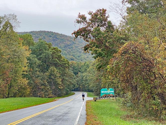
“The climb to Wintergreen is likely the most difficult in the state of Virginia and it is one of the most difficult in the Southeast United States. Located in the central part of the state it is somewhat isolated but well worth the effort to get there. Shallow to begin, the grade gradually increases as you ride along Route 664. Through thick woods in places the grade gets steeper as you head west. Scenery and little traffic most days creates a pleasant start to the ascent…” (This quote provided with the approval of John Summerson from his book The Complete Guide to Climbing (by Bike) in the Southeast, pg. 120.)
PLAN YOUR ROUTE
All climb here - 7.2 miles at 7.7% average grade and 0 descent. 32% (2.3 miles) of the climb is at 0-5% grade, 33% (2.4 miles) is at 5-10%, and 35% (2.5 miles) is at 10-15% - the grade never exceeds 15%. The steepest quarter-mile is 12.8% and there is on continuous mile at 12% grade.
See more details and tools regarding this climb's grade via the “Profile Tool” button.
Roadway: Excellent condition.
Traffic: Moderate the first three miles on Highway 664, moderate the next 2.8 miles to Wintergreen Resort, and mild for the last mile on Devils Knob Loop.
Parking: We asked to park at the gas station just before the start of the climb. Map; Street View.
Provisions: At the gas station at the start and In Wintergreen at mile six.
Before heading out on any cycling adventure check out our Things to Bring on a Cycling Trip and use our interactive check list to ensure you don't forget anything.
This climb is near a couple of climbs on the great Blue Ridge Parkway - Use the “Routes in Area” button in the menu to see what other climbs are in the area on the BRP.
You can stay in Wintergreen near the resort, and there are house rental options available in the area as well.
ROUTE MAP
MEMBER RATING
CURRENT WEATHER
PJAMM TRIPS ADVENTURE STARTER BUNDLES
Check out PJAMM Adventure's prepackaged (self-guided) cycling trips. They will help you plan, document and conquer your next adventure.
NEARBY CLIMBS (0) RADIAL PROXIMITY
FROM No Climbs Found
MEMBER REVIEWS & COMMENTS
Let us know what you thought of this climb. Signup for our FREE membership to write a review or post a comment.
Already have an account?
LOG IN HERE
dyben


What an awesome climb. I did this climb in the fall with max colors all around. The road condition is amazing and although traffic is moderate they were very respectful. There are definitely a few challenging stretches on this route. One of the better descents you can do to let it rip, especially towards the bottom. Totally worth your time!
BirdLaw900
There used to be a hill climb race up this back in the 00's, I've ridden it maybe 5 times. First 3 miles from the Brewery are slowly rising, then you make a harsh right turn into the ski resort access and it's pain for 5 miles to the top. Pavement is great. No real expansive views, you're in the woods most of the time. It can be a lot colder at the top, especially in spring & fall. I last road it August 2019 as the start of a 90 mile ride that ended at Peaks of Otter to the south. I started very early, and while it was about 65 and humid at the base at 8AM, it was 40 at the top, which made the descent brutal in my summer gear. The descent is really, really fast, especially at the bottom, so will challenge your rim brakes. I've heard there is a path at the top to hike over to the BRP, otherwise it's back down the hill to the gate, then a right turn up a brutal 1.5 mile stretch to the BRP.
Mmatt


Tough climb in through beautiful scenery. The halfway mark just prior to entering wintergreen is the hardest part to mentally overcome. Then wintergreen drive doesn't really ease up until closer to the top before devils knob gives you a last good kick! Traffic is very accommodating as they are used to bikers and the road was just repaved and painted in 2021. Great climb! Not a great downhill due to the curves so I recommend the short walk to continue your ride on the blue ridge parkway.