
18.5
PDI
9.8 mi
DISTANCE
3,124 ft
GAINED
6 %
AVG. GRADE
FULL CLIMB STATS
INTRO
PLAN YOUR ROUTE
 We've partnered with Sherpa-Map.com to bring you the best route planning tool. With a PRO Membership you can use this climb as a reference when creating your route.
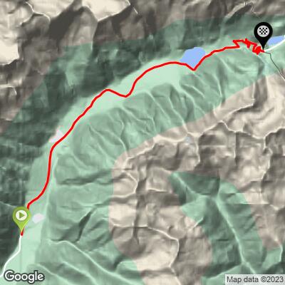
Passo Stalle climbs 15.8 km (9.8 mi) at a 6.0% average, gaining 952 m (3124 ft) from 1103 m (3620 ft) to 2049 m (6721 ft).
The average hides a very uneven profile. The first 5 km (3.1 mi) through Niedertal and Mittertal average only about 3.5%, including a nearly flat fourth kilometer. From 5 km (3.1 mi) to 9 km (5.6 mi) the road climbs hard through Obertal at 7.3-9.7%, then eases again for the 2 km (1.2 mi) along the Antholzer See.
The last 4.8 km (3.0 mi), from the end of the lake to the pass, average 8.3%, with three of those kilometers between 8.4% and 9.6%. The hardest part of the climb comes at the very end.
Steepest 0.5 km (0.3 mi): 11.7%. Steepest 1 km (0.6 mi): 10.3%. Steepest 2 km (1.2 mi): 9.3%. Steepest 5 km (3.1 mi): 7.9%.
Roadway: Paved throughout. The valley road to the Antholzer See is a normal two-lane road, but from the eastern end of the lake to the pass it narrows to a single lane full of hairpins, controlled by traffic lights. Uphill traffic from the Italian side is released at minutes 30-45 of each hour and downhill traffic from Austria in the first 15 minutes of each hour. Riders recommend setting off toward the end of the uphill window, so the cars are already ahead of you, and expecting to meet descending traffic on the way up. The pass is closed in winter - in 2026 it reopened on 22 May - so check its status before an early- or late-season ride.
Traffic: Light overall. Buses and camper vans need a special permit for the pass road, so the upper section carries mostly cars and motorbikes, released in bunches by the traffic lights. Expect more of both on summer weekends.
Parking: Antholz Niedertal has parking at the church, at the fire station and event hall, and opposite the bus stop by Gasthof Messnerwirt in the village center. To ride only the steep upper section, park at the Antholzer See - there's parking at the Tiroler Hütte by the lake and at the biathlon center a few minutes' walk away.
Provisions: The huts by the Antholzer See, including the Tiroler Hütte and the Enzianhütte at about 1650 m (5413 ft), are the last places for food and drink before the steep final 4.8 km (3.0 mi). Just over the pass on the Austrian side, the Alpengasthaus Obersee (2020 m / 6627 ft) is a popular stop.
Gear: A compact crankset and a 32-tooth cog help on the 9-10% ramps above the lake. At over 2000 m (6562 ft) the pass can be cold and windy even in summer, so carry a windproof layer for the descent, and bring front and rear lights if you plan to continue down the Austrian side, which has tunnels and avalanche galleries.
Before heading out on any cycling adventure check out our Things to Bring on a Cycling Trip and use our interactive check list to ensure you don't forget anything.
The Antholz valley is biathlon country. The Südtirol Arena opened in 1971, has hosted six World Championships (1975, 1976, 1983, 1995, 2007 and 2020) and, at about 1600 m (5249 ft), is the highest venue on the World Cup circuit. In February 2026 it hosted the Olympic biathlon events of the Milano Cortina Winter Games.
The Antholzer See covers 44 hectares and reaches 38 m (125 ft) deep. A 2.7 km (1.7 mi) nature trail circles it in about an hour and a half, with information boards on the local flora, fauna and geology - a good leg-stretcher after the ride. The valley is almost entirely German-speaking, and places carry both German and Italian names: Antholz/Anterselva, Rasen/Rasun, Staller Sattel/Passo Stalle.
Over the pass, the Obersee and the Defereggen valley lie in East Tyrol, at the southwestern edge of Austria's Hohe Tauern National Park, with alpine roses around the lake and views into the national park.
ROUTE MAP
MEMBER RATING
CURRENT WEATHER
PJAMM TRIPS ADVENTURE STARTER BUNDLES
Check out PJAMM Adventure's prepackaged (self-guided) cycling trips. They will help you plan, document and conquer your next adventure.
NEARBY CLIMBS (0) RADIAL PROXIMITY
FROM No Climbs Found
MEMBER REVIEWS & COMMENTS
Let us know what you thought of this climb. Signup for our FREE membership to write a review or post a comment.
Already have an account?
LOG IN HERE
