
20.5
PDI
9.1 mi
DISTANCE
3,304 ft
GAINED
6.6 %
AVG. GRADE
FULL CLIMB STATS
INTRO
PLAN YOUR ROUTE
 We've partnered with Sherpa-Map.com to bring you the best route planning tool. With a PRO Membership you can use this climb as a reference when creating your route.
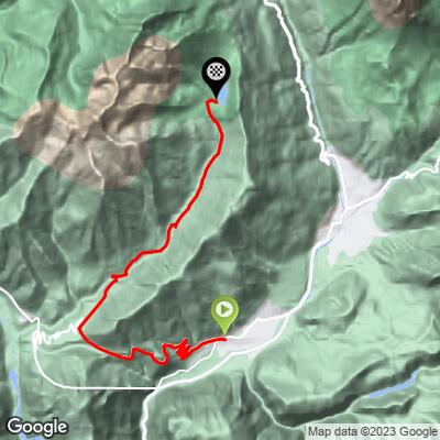
The full route is 14.6 km (9.1 mi) at a 6.6% average, with 1,007 m (3,304 ft) of gain. The first 6 km, up to Passo Gobbera, are steady: 7.2% in the first kilometer, then 6.4%, 6.0%, 5.9%, 4.5% and 4.1% as you approach the pass. Just past the pass the road dips slightly (about -1.9%), then climbs again at 3.3% and 5.2%.
From about 9 km the grade steps up to 8.6%, 7.7%, 10.0%, 12.6%, 11.2% and 9.8% to the finish. The steepest 1 km averages 12.7%, the steepest 5 km averages 10.3%, and the steepest 100 m reaches 17.5%. If you want to ride only the pass, the climb is about 6 km at roughly 5.7%; the Calaita extension is where the effort lives.
Roadway: The road from Imer to Passo Gobbera is asphalt and has been reported in excellent condition, with about eight hairpins in its first half. The turnoff for Lago di Calaita leaves the pass road a short distance beyond the Gobbera, and the road to the lake is steeper and narrower; one rider report describes the road to the lakeside inn as in poor shape, so take the descent carefully.
Traffic: Light on the pass road, other than on peak summer days. Lago di Calaita draws many visitors in summer and can get crowded, so expect more cars on the upper road on fine weekends.
Parking: Imer is a small village at the foot of the climb; start from there and leave the car near your lodging. At Passo Gobbera there is a small group of buildings with a restaurant and a hotel, and a fountain in the square by the church for refilling bottles. At the lake there is ample parking, but it can fill up in summer.
Provisions: There is a fountain by the church at Passo Gobbera for refilling bottles on the way up. At the top, the Albergo-Ristorante-Bar Miralago beside Lago di Calaita serves local dishes - canederli and spätzle are worth ordering after the last steep ramps - and there is an e-bike charging point at the lake.
Gear: Gearing matters on the final four kilometers: a compact crankset with a 30-34 rear sprocket is what you want for 10-12% pitches. The lake sits above 1,600 m, so pack a light jacket for the descent.
Before heading out on any cycling adventure check out our Things to Bring on a Cycling Trip and use our interactive check list to ensure you don't forget anything.
Primiero is a quiet corner of the Dolomites, and this ride is a good way to sample it. Above Passo Gobbera, the small chapel of San Silvestro stands on a rock spur at about 970 m below Monte Totoga, documented since the 13th century and once the home of a hermit; it is usually closed, but opens on Mondays from June to September, on May 1 for the Gobbera festival and on a few other dates. Monte Totoga itself holds tunnels and gun positions from the First World War.
At the lake, the larches turn in late autumn and the area is far quieter then than in summer. From the Primiero valley floor a cycle path follows the Cismon stream toward Siror and San Martino di Castrozza, a good recovery ride for the day after. The nearby climbs of Passo Brocon, Passo Cereda and Croce d'Aune have their own pages. See other climbs nearby, or build a custom route from here, with our Routes in the Area tool.
ROUTE MAP
MEMBER RATING
CURRENT WEATHER
PJAMM TRIPS ADVENTURE STARTER BUNDLES
Check out PJAMM Adventure's prepackaged (self-guided) cycling trips. They will help you plan, document and conquer your next adventure.
NEARBY CLIMBS (0) RADIAL PROXIMITY
FROM No Climbs Found
MEMBER REVIEWS & COMMENTS
Let us know what you thought of this climb. Signup for our FREE membership to write a review or post a comment.
Already have an account?
LOG IN HERE
