
22.8
PDI
7.3 mi
DISTANCE
3,176 ft
GAINED
8.1 %
AVG. GRADE
FULL CLIMB STATS
INTRO
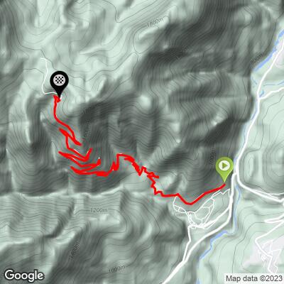
Via Da Rin is the classic road climb out of Lozzo di Cadore: 11.7 km (7.3 mi) and 968 m (3,176 ft) of gain at an 8.1% average, rising from 808 m (2,650 ft) in the village to 1750 m (5,741 ft) on the edge of the Pian dei Buoi plateau. Locals know the road as the Strada del Genio - a narrow military road built by army engineers - and it climbs through more than two dozen hairpins with almost no flat ground along the way.
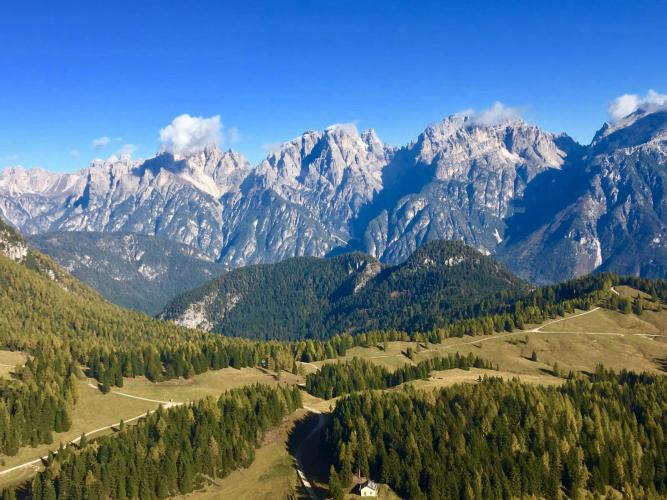
Most of the climb is sheltered by forest, and the grade is steady rather than savage - the kilometers mostly run between 7% and 10%, with a short 14% pitch early on. The payoff comes at the top, where the trees open onto the high summer pastures of Pian dei Buoi, with the walls of the Marmarole right above you and views that reach the Antelao and the Tre Cime di Lavaredo.
The plateau carries real history: the First World War fortifications of Forte Col Vidal sit a short ride beyond the finish, and two mountain huts - Rifugio Ciareido and Rifugio Baion - serve food in season. One thing makes this climb unusual: in summer the road runs on a timed one-way schedule for traffic (see Roadway & Parking), so plan the timing of your ride before you go.
PLAN YOUR ROUTE
 We've partnered with Sherpa-Map.com to bring you the best route planning tool. With a PRO Membership you can use this climb as a reference when creating your route.
 The climb averages 8.1% over 11.7 km (7.3 mi) and is remarkably consistent - almost every kilometer falls between 7% and 10%, with only the third kilometer easing to around 5%.
The steepest half-kilometer comes early, at 14.1%, in the first two kilometers above the village. The steepest full kilometer averages 11.4%, and the hardest 5 km average 9.0%, so settle into a sustainable rhythm from the start - there's no real recovery section until the plateau.
The final kilometer still averages close to 9.5% before the road flattens out onto Pian dei Buoi at 1750 m (5,741 ft).
Roadway: The road is paved the whole way to the plateau - mostly asphalt, with concrete on parts of the upper section - and riders regularly climb it on road bikes. It is very narrow, often only one car wide, with few places to pass, and rider reports describe the asphalt as not always perfect on the technical descent, plus a short rougher, partly gravel stretch near the top. The road crosses the Rio Boa gully, which is prone to debris flows after heavy storms; the Province carried out emergency clearance there in July 2023, and the municipality can close the road during regional weather alerts. Check with the Comune di Lozzo di Cadore before riding if storms are forecast.
Traffic: From 1 July to 15 September a municipal ordinance puts the road on a timed one-way schedule: uphill only from 9:00 to 13:00, downhill only from 14:00 to 18:00, and two-way outside those hours. The easiest plan on a bike is to ride with the flow - climb during the morning uphill window and descend after 14:00 - so you never meet a car head-on on this narrow road. Mid-August (the Ferragosto holiday week) can bring a lot of cars; outside peak summer, traffic is light.
Parking: Lozzo di Cadore is a small village on the SS51 Alemagna; park in the village near the start of Via Da Rin where permitted. If someone is driving up to meet you, the main car park on the plateau is at the Bivio dei Pellegrini (1812 m / 5,945 ft), a short way beyond the finish, where the paved road ends and the dirt tracks toward the huts begin.
There are no services on the climb itself, so fill bottles in Lozzo di Cadore before you start. At the Bivio dei Pellegrini, just past the finish, there's a fountain next to the old barracks, and in season Rifugio Ciareido (1969 m / 6,460 ft) and Rifugio Baion (1828 m / 5,997 ft) serve food and drink - Ciareido is about a 20-minute walk from the car park, so bring shoes you can walk in if you plan to stop.
A compact crankset with a 30- or 32-tooth cog is a good match for the steady 8-10% grades. Summer thunderstorms can build quickly over the Marmarole in the afternoon, so pack a jacket for the descent, and brake early - the descent is narrow and technical, with blind hairpins.
Before heading out on any cycling adventure check out our Things to Bring on a Cycling Trip and use our interactive check list to ensure you don't forget anything.
Lozzo di Cadore sits in the Centro Cadore on the SS51 Alemagna, a few kilometers from Calalzo di Cadore, the end of the rail line from Belluno and Padua - handy if you're coming without a car.
Pian dei Buoi is worth time off the bike. The First World War fortifications of Forte Col Vidal and the Great War trails of the Park of Memories are a short walk or ride from the finish, and the mountain-bike route that continues past the forts and down the Val da Rin to Auronzo di Cadore is a local favorite if you're riding a gravel or mountain bike.
The Cadore is dense with climbs - Passo Mauria, Passo Sant'Antonio, and Sella Ciampignotto all start within a few kilometers of Lozzo - and our Routes in the Area tool is the easiest way to see what else is nearby and link climbs into one ride.
ROUTE MAP
MEMBER RATING
CURRENT WEATHER
PJAMM TRIPS ADVENTURE STARTER BUNDLES
Check out PJAMM Adventure's prepackaged (self-guided) cycling trips. They will help you plan, document and conquer your next adventure.
NEARBY CLIMBS (0) RADIAL PROXIMITY
FROM No Climbs Found
MEMBER REVIEWS & COMMENTS
Let us know what you thought of this climb. Signup for our FREE membership to write a review or post a comment.
Already have an account?
LOG IN HERE
