
27.2
PDI
16.6 mi
DISTANCE
5,029 ft
GAINED
5.3 %
AVG. GRADE
FULL CLIMB STATS
INTRO
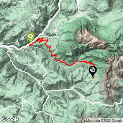
San Cipriano/Passo Nigra climbs 26.7 km (16.6 mi) from the valley village of Prato all'Isarco up into South Tyrol's Val di Tires, gaining 1533 m (5,029 ft) at a 5.3% average grade to finish near Passo Nigra (Nigerpass) at roughly 1739 m (5,704 ft) - just above the pass's real high point of 1690 m.
The route runs the full length of Val di Tires, a quieter, less-discovered valley tucked beneath the Catinaccio (Rosengarten) massif inside the Sciliar-Catinaccio Natural Park. It passes through Tires village and then San Cipriano, a hamlet at 1,071 m that serves as one of the main trailheads into the Catinaccio group, before the final 10 km of switchbacks up to the pass, where grades push into the low teens.
Traffic is busiest in the first few kilometers out of Prato all'Isarco, which sits on a more heavily-traveled stretch of the Val d'Ega road; it thins out noticeably past Tires, and the upper switchbacks through forest and alpine pasture are quiet.
The steepest kilometer averages 11.6%, and the steepest mile 11.4% - both concentrated in that closing stretch above San Cipriano.
Passo Nigra also connects through to Val d'Ega and Passo Costalunga (Karerpass) on the far side, so a rider based in the area has several ways to link this climb into a longer loop - see other climbs nearby with our Routes in the Area tool.
PLAN YOUR ROUTE
 We've partnered with Sherpa-Map.com to bring you the best route planning tool. With a PRO Membership you can use this climb as a reference when creating your route.
 San Cipriano/Passo Nigra climbs 26.7 km (16.6 mi) and gains 1,533 m (5,029 ft), averaging 5.3% from Prato all'Isarco at about 326 m (1,071 ft) up to roughly 1,739 m (5,704 ft) near the pass.
The grade builds gradually rather than starting hard. The lower valley section out of Prato all'Isarco and through Tires is gentle, and the real climbing is concentrated in the final third, above San Cipriano, where the road switchbacks steeply through forest toward the pass. The steepest kilometer averages 11.6%, and the steepest mile 11.4% - both well above the overall average, so expect the difficulty to be back-loaded.
Roadway: The road up Val di Tires is paved the entire way from Prato all'Isarco through Tires and San Cipriano to Passo Nigra, and is generally well-maintained. It's a genuine mountain road with tight hairpins in its upper third, so check current conditions before an early- or late-season attempt, since the pass sits near 1,700 m and can hold snow into spring.
Traffic: Busiest in the first couple of kilometers out of Prato all'Isarco, where the road shares space with Val d'Ega traffic; it thins out noticeably once you're past Tires. The upper valley and the switchbacks above San Cipriano are quiet, shared mostly with hikers headed for the Catinaccio trailheads.
Parking: Prato all'Isarco is a small village with limited but workable on-street parking near the village center and the MPREIS supermarket on Blumauer Strasse - a sensible last stop for supplies before heading up the valley.
Top up in Prato all'Isarco - there's an MPREIS supermarket in the village, the last reliable grocery stop before the climb. Tires and San Cipriano both have small shops, bars, and hotels catering to hikers headed into the Catinaccio group, so a mid-climb coffee or water refill is realistic even outside of the valley's two towns. At the top, Rifugio Passo Nigra sits right at the pass and serves food and drink in season, making it a good spot to refuel before the descent.
Before heading out on any cycling adventure check out our Things to Bring on a Cycling Trip and use our interactive check list to ensure you don't forget anything.
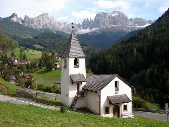
San Cipriano (St. Zyprian), the hamlet about two-thirds of the way up, is one of the main gateways into the Catinaccio/Rosengarten group - its 13th-century Zypriankirche, dedicated to Saints Cyprian and Justina, is worth a quick stop, and the hamlet is a popular base for hikers headed up toward the Vajolet Towers. Val di Tires itself is one of the Dolomites' quieter valleys, without the crowds of Val Gardena or Alta Badia just over the ridge, despite sitting inside the same Sciliar-Catinaccio Natural Park.
Passo Nigra connects through to Val d'Ega and the Costalunga/Karerpass area on the far side, both used by other PJAMM climbs - worth combining into a longer loop if you're based in the region for more than a day. Prato all'Isarco, at the base, sits right on the Isarco Valley cycle path linking Bolzano to Bressanone, so it's an easy add-on to a longer tour through South Tyrol rather than a standalone destination climb.
ROUTE MAP
MEMBER RATING
CURRENT WEATHER
PJAMM TRIPS ADVENTURE STARTER BUNDLES
Check out PJAMM Adventure's prepackaged (self-guided) cycling trips. They will help you plan, document and conquer your next adventure.
NEARBY CLIMBS (0) RADIAL PROXIMITY
FROM No Climbs Found
MEMBER REVIEWS & COMMENTS
Let us know what you thought of this climb. Signup for our FREE membership to write a review or post a comment.
Already have an account?
LOG IN HERE
