
25.4
PDI
8.7 mi
DISTANCE
3,506 ft
GAINED
7.6 %
AVG. GRADE
FULL CLIMB STATS
Page Contributor(s): Lisa Irizarry and Matthew Jiang, NY, NY
INTRO
Col de la Moutière climbs 14.0 km (8.7 mi) from Saint-Dalmas-le-Selvage - at 1,500 m, the highest village in the Alpes-Maritimes - gaining 1,069 m (3,506 ft) at a 7.6% average grade to reach 2,446 m (8,024 ft). It's rated Hors Catégorie, and though it lives permanently in the shadow of its famous neighbor, the Cime de la Bonette, it's a serious climb in its own right.
The climb is paved the entire way to the col - the gravel most descriptions of this area mention only begins on the far side, on the connector track toward the main Bonette road or the descent to Bayasse, well past where this climb ends. From the village the road climbs in switchbacks through larch forest before the trees thin out into open, rock-strewn alpine pasture, with long views back down the Vallon de Sestrière and across to the Cime de la Bonette itself. Traffic is close to nonexistent - this is one of the quietest paved climbs in the Mercantour, visited mostly by the odd motorcyclist and hikers headed into the Parc National du Mercantour that borders the upper road.
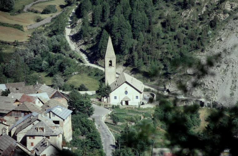
Saint-Dalmas-le-Selvage itself is worth lingering in before or after the ride: a tiny, historic hamlet of fewer than 100 residents with a parish church known for its facade fresco of the Roman soldier Saint Dalmas and a set of 18th-century sundials.
PLAN YOUR ROUTE
 We've partnered with Sherpa-Map.com to bring you the best route planning tool. With a PRO Membership you can use this climb as a reference when creating your route.
 Col de la Moutière averages 7.6% over 14.0 km (8.7 mi), with the steepest sustained riding concentrated in the upper two-thirds of the climb. The steepest 100 yards reaches 13.8%, and the steepest full mile still averages 10.7%.
The lower kilometers out of Saint-Dalmas-le-Selvage climb through forest in a series of switchbacks at a moderate, fairly even grade. The pitch increases noticeably as the road breaks above the tree line into open alpine terrain, with the final kilometers to the col holding the climb's most sustained double-digit gradients before easing again right at the summit.
Roadway: The road is paved the entire way from Saint-Dalmas-le-Selvage to Col de la Moutière. Surface quality declines noticeably once you're above the village - still ridable on a road bike, but with patched sections and rougher pavement than the smooth road through town. The gravel this area is known for (the connector track toward the main Cime de la Bonette road, and the separate descent to Bayasse) begins only past the col, beyond where this climb ends. Snow can linger into early summer at this altitude, so check conditions before an early-season attempt.
Traffic: About as light as it gets - this is a dead-end mountain road with no through-traffic beyond the occasional motorcyclist or hiker headed into the Parc National du Mercantour, whose boundary runs along the upper part of the climb.
Parking: Free parking is available on the street in Saint-Dalmas-le-Selvage, right in the small village center where the climb begins.
Hors Catégorie for good reason - 1,069 m (3,506 ft) of gain finishing above 2,400 m means both a real physical effort and genuinely thin air near the top. A compact crank with a wide-range cassette (30-32 teeth or more) is the standard recommendation for the steeper pitches in the upper third.
There's nothing open along the route itself - no cafe, no shop - so fill up in Saint-Dalmas-le-Selvage before you start. Dress for a big temperature swing: it can be warm and sheltered in the village and near-freezing and windy at the summit, especially outside midsummer.
Check your tires and brakes before you go given the patchier pavement above the village, and know that there are no bike shops anywhere near this climb - the nearest real services are back down in Saint-Étienne-de-Tinée.
Before heading out on any cycling adventure check out our Things to Bring on a Cycling Trip and use our interactive check list to ensure you don't forget anything.
Saint-Dalmas-le-Selvage is worth an hour of your time beyond just the start of a ride. At 1,500 m it's the highest village in the Alpes-Maritimes, home to fewer than 100 year-round residents, and its historic parish church carries a facade fresco of the Roman soldier Saint Dalmas along with a set of 18th-century sundials on the surrounding houses - easy to see on foot in the time it takes to refill water bottles.
Saint-Étienne-de-Tinée, about 10 km back down the valley, is the practical base for this area with more lodging, restaurants, and services, and it's also the starting town for the Cime de la Bonette climb - see our Cime de la Bonette page for more on staying in that area.
What sets this side apart is the quiet: where the Bonette's main road draws a steady stream of cars and motorcycles all summer, this road to Col de la Moutière sees almost none.
Ride between mid-June and September; snow lingers into early summer this high, and shoulder-season mornings can be cold even when the forecast down in the valley looks mild. Check conditions at altitude before you go with our Weather tool.
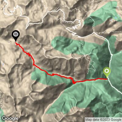
ROUTE MAP
MEMBER RATING
CURRENT WEATHER
PJAMM TRIPS ADVENTURE STARTER BUNDLES
Check out PJAMM Adventure's prepackaged (self-guided) cycling trips. They will help you plan, document and conquer your next adventure.
NEARBY CLIMBS (0) RADIAL PROXIMITY
FROM No Climbs Found
MEMBER REVIEWS & COMMENTS
Let us know what you thought of this climb. Signup for our FREE membership to write a review or post a comment.
Already have an account?
LOG IN HERE
