15
PDI
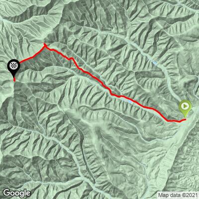
8.9 mi
DISTANCE
2,725 ft
GAINED
5.7 %
AVG. GRADE
FULL CLIMB STATS
Page Contributor(s): John Summerson, The Complete Guide to Climbing (By Bike), 2nd Edition.
INTRO
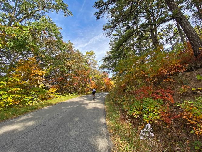
"Reddish Knob is a challenging and scenic ascent up to the very top of Reddish Knob Mountain in western Virginia. The road is narrow over part of the route and the grade is shallow to start but gradually steepens as you ride west. Eventually you pass a dam on your left. Beyond the dam the climb averages 7% grade and at a big switchback at mile 6.8 the road gets very narrow (only one vehicle can pass at a time in places) as it enters thick trees." (This quote provided with the approval of John Summerson, from his book, The Complete Guide to Climbing (By Bike) in the Southeast, pg. 118.). This is Virginia's #5 Top Bike Climb.
PLAN YOUR ROUTE
Average grade for the climb is 5.7% (6.3% climb only). 60% of the climb is at 5-10% grade and 6% is at 10-15%. The steepest quarter-mile is 10.6% and steepest mile is 9.3%.
See more details and tools regarding this climb's grade via the “Profile Tool” button.
Roadway: Narrow two lane rural road with no shoulder in good to fair condition.
Traffic: Minimal - you won't see more than a handful of cars on this fun climb.
Parking: We had a hard time finding what we considered a good/safe place to park, and finally shoehorned into a spot on the side of the road just past the bridge over the North River on Tilgham Road - Map (note that there is no Street View on this route - that tells you something!).
Provisions: None on the route but there is a gas station that has snacks and beverages three miles east of the start of our climb - Map.
Before heading out on any cycling adventure check out our Things to Bring on a Cycling Trip and use our interactive check list to ensure you don't forget anything.
You would enjoy adding the back side of this climb to your day with an out-and-back which includes Reddish Knob (West Virginia) - 27 miles gaining 4,410' (Map).
ROUTE MAP
MEMBER RATING
CURRENT WEATHER
PJAMM TRIPS ADVENTURE STARTER BUNDLES
Check out PJAMM Adventure's prepackaged (self-guided) cycling trips. They will help you plan, document and conquer your next adventure.
NEARBY CLIMBS (0) RADIAL PROXIMITY
FROM No Climbs Found
MEMBER REVIEWS & COMMENTS
Let us know what you thought of this climb. Signup for our FREE membership to write a review or post a comment.
Already have an account?
LOG IN HERE
DrBullet
Early October was a great time to ride this climb. Cooler temps and trees turning for bursts of colour in a sea of green. The climb is mostly a steady gradient. The asphalt gets worse the higher you climb so definitely advise caution on the descent. The 360 degree view from the top is a rare treat in this area where glimpses through trees are often the only tantalizing hint of what might be spectacular views!
rcfry1


Best part of the climb and a true story...while dragging myself up the climb at probably only 6-7 mph a pickup truck meets me coming down the mountain. He passes and then turns around and comes back to me. Keep in mind I was in rural VA, his truck had a confederate flag embossed on his back window and a gun rack over the seat. He stops, spits out tobacco juice and I'm thinking this is not going to be good! He says, "Hey boy, watch out for the stream overflowing and running across the road about a 1/2 mile up the road." I thanked him and he said, "have a good day", and drove off. I can tell you that the shift in my paradigm was the best part of my day and the climb.