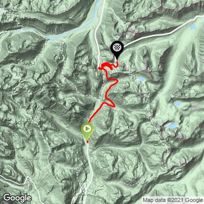
16.3
PDI
11.2 mi
DISTANCE
3,101 ft
GAINED
5.2 %
AVG. GRADE
FULL CLIMB STATS
Page Contributor(s): Bruce Hamilton/Stacy Topping, USA; Kyle Stanton-Wyman, North Bend, WA
INTRO
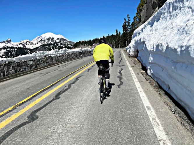
Ranked #5 in Washington, this is a wonderfully scenic bike climb in northern Washington, 90 miles southeast of Tacoma and within ten miles of Mt. Rainier at locations along the climb.
PLAN YOUR ROUTE
This 12.5 miles climb averages 4.8%. 30% (3.7 miles) is at grade 0-5%, and 67% (8.4 miles) is 5-10%. The steepest quarter-mile is 6.3% and steepest continuous mile is 6.1%.
Roadway: Two lane highway in excellent condition with a narrow shoulder most of the climb.
Traffic Mile to moderate
Parking: Park on the side of Hwy 123 at the entrance to Grove of the Patriarchs Trail 2 miles from the start of the climb - Map; Street View.
Provisions: None on the route.
Before heading out on any cycling adventure check out our Things to Bring on a Cycling Trip and use our interactive check list to ensure you don't forget anything.
This climb is in Mt. Rainier National Park.
This is a remote climb but there are a few options for motel rentals in the area. There are also houses and cabins for rent in and north of Packwood, WA.
Use the “Routes in Area” button on the menu bar above to see other bike climbs in this area.
ROUTE MAP
MEMBER RATING
CURRENT WEATHER
PJAMM TRIPS ADVENTURE STARTER BUNDLES
Check out PJAMM Adventure's prepackaged (self-guided) cycling trips. They will help you plan, document and conquer your next adventure.
NEARBY CLIMBS (0) RADIAL PROXIMITY
FROM No Climbs Found
MEMBER REVIEWS & COMMENTS
Let us know what you thought of this climb. Signup for our FREE membership to write a review or post a comment.
Already have an account?
LOG IN HERE